The New Google Earth Imagery – February

Google has just pushed out a fresh batch of new imagery to a variety of places around the world.

dubai.jpg

Due to the new “Pretty Earth” imagery, it’s more difficult to spot fresh imagery. Also, the imagery this month arrived in Google Maps before Google Earth, which threw us off a bit. In any case, here are some of the locations that GEB readers have identified as having fresh imagery. Many of them were made aware of the new imagery via the Follow Your World notifications, which we certainly encourage you to sign up for.

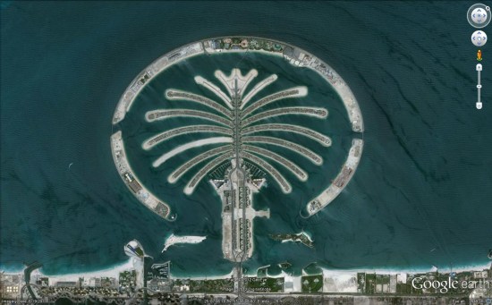
Here is the list of updated areas we know about so far:

  • Canada: Villeneuve
  • Italy: Vernazza
  • Romania: Deva
  • Spain: Villacariedo
  • United Arab Emirates: Dubai
  • United States: California (Chino, Eureka), Illinois (Decatur), Louisiana (Alexandria), North Dakota (Minot), Tennessee (Johnson City, Kingsport)

The Google Earth Community


The Google Earth Community, formed in 2002 when Google Earth was still an independent product called “Keyhole”, has been an excellent resource for Google Earth users. Not only was the community a great place to post new files that you create/discover, but you could get answers to almost any Google Earth-related question in there.


bbs.jpg 

They even added a Google Earth Community layer to Google Earth back in 2005 to show off the great files that users have added, which you can still find under the [Gallery] section of your Layers.


layer.jpg 

Recently, the GEC had had some stability issues. Because it was based off of an older BBS technology, it was having increasing amounts of trouble under an ever-growing load. To fix that, Google is now moving it over to a Google Groups-based system which should help with those issues tremendously.

Right now Google is in the process of moving all of the posts and attachments to the new system. With more than 1.2 million posts on there, it’ll take some time. They’re hoping to have the data ported over by next week, and we’ll certainly let you know when it goes live.

If you have any questions or problems in the meantime, you can use the Google Earth forums already in place in Google Groups

via: GoogleEarthBlog

Highlighting terrain by only showing the roads on the map


What if someone were to create a map that showed every street in the country and nothing else? Fathom Information Design did just that, and the results are amazing!


streets.jpg 

It feels kind of like the city lights of Earth that we recently wrote about, as you can clearly see cities form without any kind of borders or other overlays in there.

What’s even more remarkable about the “All Streets” map is how clearly the mountain ranges are defined. Simply by drawing in the roads, you can see them without any difficulty. A great example is the Appalachian Mountains, seen here:


appalachian.jpg 

You can view and/or purchase the map over on the Fathom website.

(via +Adrienne St. Aubin)