The Google Earth Community


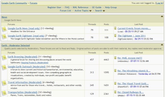
The Google Earth Community, formed in 2002 when Google Earth was still an independent product called “Keyhole”, has been an excellent resource for Google Earth users. Not only was the community a great place to post new files that you create/discover, but you could get answers to almost any Google Earth-related question in there.


bbs.jpg 

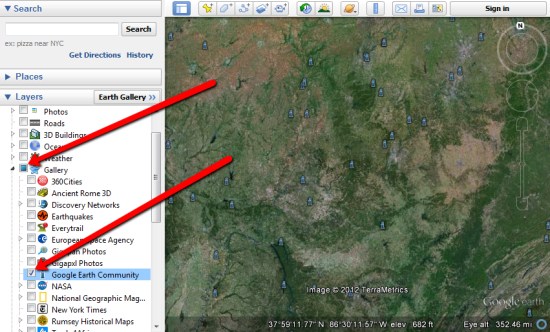
They even added a Google Earth Community layer to Google Earth back in 2005 to show off the great files that users have added, which you can still find under the [Gallery] section of your Layers.


layer.jpg 

Recently, the GEC had had some stability issues. Because it was based off of an older BBS technology, it was having increasing amounts of trouble under an ever-growing load. To fix that, Google is now moving it over to a Google Groups-based system which should help with those issues tremendously.

Right now Google is in the process of moving all of the posts and attachments to the new system. With more than 1.2 million posts on there, it’ll take some time. They’re hoping to have the data ported over by next week, and we’ll certainly let you know when it goes live.

If you have any questions or problems in the meantime, you can use the Google Earth forums already in place in Google Groups

via: GoogleEarthBlog

OpenSocial Container and Application Developers

Do you work on the implementation of a container or develop applications within existing OpenSocial containers? If so, we’d love to interview you in a new blog post series that will allow developers to showcase the new and innovative things that they are doing with OpenSocial.

We’re especially interested in hearing from the community about:

  • The challenges you’ve experienced while working with the specification and how you overcame them.
  • Are there any technologies or specifications that you’ve integrated with an OpenSocial container or application that you believe married well with the OpenSocial specification?
  • How is OpenSocial being used within enterprise solutions?
  • How is OpenSocial being used on mobile devices?
  • Are there any technical implementations that you thought worked especially well? Code implementations to showcase these integrations are always welcome.
  • Do you have any helpful tips, techniques or snippets that have been useful to you in the past?

Using these “OpenSocial in the wild” posts, we’re hoping to hear more voices from the community and give creators the spotlight. These are the people that are on the front lines, implementing, and hearing from them what works, what failed, and what customers took to as far as features will allow us all to better understand how this technology is being used.

If you would like to be heard, please e-mail me at nakedtechnologist at gmail dot com and tell me, in brief, what you’re doing with OpenSocial. I’ll ask you a series of questions from that initial overview and then feature you in our new “OpenSocial in the wild” blog posts.

Perth bushfires

From one extreme to another… today top news is bushfires in WA and on the outskirts of Perth. Tens of houses have already been lost. Alerts are published by Fire and Emergency Services WA and the Department of Environment and Conservation. I was looking for online maps but could not locate anything with exception of the good old FireWatch. So, here is a couple of screen captures from aus-emaps.com Bushfire Incidents map:

Interestingly, DEC publishes number of hits on its online reports and numbers are quite surprising… high tens but no more than 200. There is lots of text, occasional situation map in pdf but overall not an easy read… It appears that despite all the initiatives, by the community, the governments of all levels, academics, media and private companies there is still no single “geographic information system” available for the public to see first hand what is happening in near real time. There is still a big void in information. Why? Is lack of funding the main issue or lack of coordinated approach by various authorities? Or lack of enthusiasm to carry on development and support for something that may only be used a few days a year (…every few years!)? It would be interesting to hear from others what do you think …

End Note:
The latest community initiative called Bushfire Connect will be officially launched on Monday 7th February, initially focusing only on Victoria.