Google Maps: See the world through a lens with the Panoramio Layer

When looking at a Google Map it’s not always easy to get a sense for what the area looks like on the ground. Satellite imagery can indicate the terrain, whether it is urban or rural, desert or mountainous, and Street View can help in built up areas. But to convey the beauty of more scenic locations you really need a photograph.

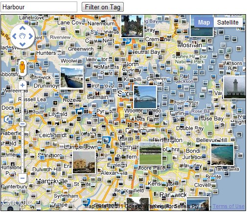
For this reason we’re happy to make available the Photos layer from Google Maps to Maps API developers. The Photos layer adds thumbnails of geotagged photos to the map, which are sourced from Panoramio. They are a great way to add additional context to a map, and an on the ground perspective. Photos can be added to an API map using the PanoramioLayer class of the new Panoramio library. We have also added some additional flexibility to enable you to customize both the behaviour of the layer and the thumbnails shown by your application.

Firstly, applications can listen for clicks on the photo thumbnails and obtain information about the thumbnail concerned, which can then be used to load the photo using the Panoramio Widget API. Secondly, applications can also restrict the thumbnails shown to those of a particular user, or those with a particular tag. This allows you to only show thumbnails for photos that you have uploaded to Panoramio, or only show photos relating to a specific subject, such as beaches. You can try experimenting with different tags in the example below:

For more information on using the PanoramioLayer, please take a look at the Maps API documentation. As always, if you have any questions about using this or any other Maps API feature, we recommend the Maps API forum. We hope this new layer will help to brighten up your maps, and help your users get a better sense of the landscape you are mapping.
GetListed Portland

Today, I am presenting at the sixth GetListed.org Local University in Portland, Or. If you are coming PLEASE take a moment to introduce yourself as I would love to meet you.

For those of you that attended the presentation these links will provide background information and details for a pathway to dig deeper into the world of managing your listing on Google Maps. For those of you that are not in attendance, the links provide a good overview of critical base line ideas and tactics that every local campaign should embrace.
Google Maps – Its not your mother’s yellow pages.

Slide 2 – January 2011 Search Engine Market Share
Slide 12/13 – The Importance of Page One Visibility
Slides 16/17 – How the Google Cluster Works
Slide 21- Choosing the Right Category – A Tool
Slide 21 – Writing a Great Business Description
Slide 21 – Google Places Policies: Quality guidelines
Slide 22 – Creating a GeoSitemap – A tool
Slide 28/29 Local Search Ranking Factors – the many variables
Slide 28/29 A brief list of 10 Ranking Factors – somewhat old but still valid and a quick read
Slide 28/29 Thinking about your Business Name in the Internet Era
Slide 30 – Custom Maps – A Goldmine
Slide 30 – User Generated Content – Geo Tagged Photos
Slide 30 – How To Gather Reviews
Slide 30- Where to Gather Reviews
Slide 31- The Importance of Citations
Slide 31 – 20 Citation Sources in the US
Slide 36- A Listing management tool

Related posts:

  1. GetListed Local U, Cleveland
  2. GetListed Local University – Twin Cities
  3. GetListed Birmingham

Geotagging photos with Panoramio and Google Latitude

It is 9 a.m. and the thermometer shows -15°C. I have a Nexus S with Google Latitude in my left pocket and my new Lumix LX-5 in the right one. I am in Davos and I am ready for a fantastic day of skiing when I decide to use the new feature of Panoramio: geotagging photos with Google Latitude.

Panoramio is a community photos website that enables digital photographers to geo-locate, store and organize their photographs — and to view those photographs in Google Earth.

Google Latitude allows you to share your location with friends and view their location on a map. When enabled, Google Latitude History allows you to store your previous locations and this allows you to match your photos with the locations stored in Google Latitude History.

By combining Panoramio and Google Latitude your photos get geotagged automatically as the time stamp of the photos is matched with your location record in Google Latitude History. To use this feature you need to explicitly enable it in your Settings page in Panoramio. With your permission, Panoramio will access your Google Latitude History to find out your location at the time when your photos are taken, so make sure the time in your camera is correct and it matches the value you entered in the Panoramio Settings page.

Using Google Latitude while skiing allows you to find your friends when you get lost on the slopes, and at the same time it allows you to focus on taking nice photos not worrying about the location where you are taking them.

Mapping photos within the city is normally not a problem as you can easily remember street names, points of interest, etc. It is much more difficult to do it in the countryside and that is why I decided to give the feature a whirl while skiing in Davos:

Thanks to Google Latitude, my photos were geotagged just after uploading them in Panoramio. The day was great, snow was perfect, weather was amazing and when I arrived home my photos were already geo-positioned.

For more information about this feature please check our help content and as always we will be happy to hear your feedback in the Panoramio forum.