U.S. Migration Flows

U.S. Migration Flows (screenshot)

Interactive maps of domestic migration in the United States from the Pew Research Center. “They show gains and losses only from people who move from one state to another, and not from births, deaths or movement to and from other countries, which are the other sources of population change.” Flash required.

New Google Earth Imagery – February 24

Google has just pushed out some fresh imagery to various parts of the world, with thanks going to sharp-eyed GEB reader ‘Andreas’ for being the first to point it out to us!

hohenfels.jpg

The full extent of the update is still unknown, but as is usually the case, you can use Google Maps to determine for sure whether or not a specific area is fresh. This new imagery isn’t in Google Maps yet, so you can compare Earth vs. Maps to see what’s new; the fresh imagery is already in Google Earth, but the old imagery is still in Google Maps. If you compare the two side-by-side and they’re not identical, that means that you’ve found a freshly updated area in Google Earth!

[UPDATED — 24-February, 11:00am EST]

  • Australia: Melbourne — thanks ‘David’
  • Bosnia Herzegovina: Various areas — thanks ‘Andreas’
  • Croatia: Various Areas — thanks ‘Andreas’
  • Germany: Hohenfels, Marl — thanks ‘Andreas’
  • Norway: Various areas — thanks ‘Andreas’
  • Romania:Various areas — thanks ‘Andreas’
  • Sweden: Areas along the western part of the country — thanks ‘John’
  • UK: London — thanks ‘Carl’
  • United States: Illinois (west central) — thanks ‘KennyB’

If you find any other updated areas, please leave a comment and let us know!

Learn more about the US Presidents by using Google Earth

Today is “President’s Day” in the United States, and Google has built a pretty neat site using the Google Earth Plug-in to show off information about all 44 presidents that we’ve had in the US.

jfk.png

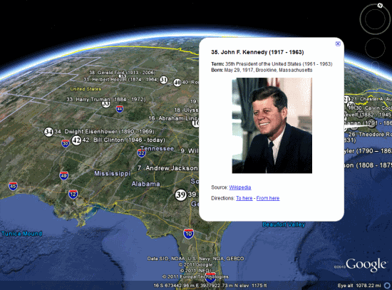
You can view it for yourself in the U.S. Presidents Showcase page, which uses the Google Earth Plug-in and various tours to show you around. If you’d rather just explore the information on your own, as seen above, you can use this KMZ file to see them in Google Earth.

In their President’s Day blog entry, Google also points out a few other presidential items to explore in Google Earth, such as:

• A quick tour of the White House in 3D (KML)

• Valley Forge National Park (3D Warehouse)

Beyond those, here are a few other Presidential Google Earth Resources:

• The tour of all 50 State Capitol buildings, as many of the U.S. Presidents were state Governors at one time.

• Grave site locations for many of the Presidents (KMZ, via Google Earth Hacks)

If you know of other great resources to help educate on President’s Day, please leave a comment below and let us know about them!