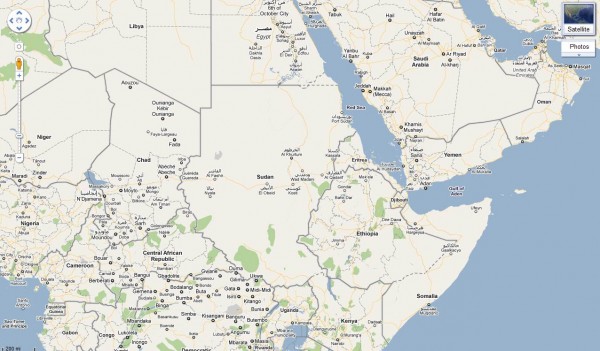
Better map of Southern Sudan

Sudan is preparing to vote on January 9 to decide if the South will become independent from the North. The referendum is part of the Comprehensive Peace Agreement signed in 2005 ending the Civil War, which lasted 22 years and led to the deaths of an estimated 2 million people. Analysts fear the possibility of renewed violence.

Sudan is a huge country (2.5 million km2), with an estimated population of 44 million people, but it’s poorly mapped. Without basic geospatial information, it’s difficult for humanitarian agencies and first responders to monitor and evaluate the risks and current needs, target their efforts, and mobilize proper resources. At times like these, it is critical to have good maps on roads, settlements, voting stations, hospitals, buildings and other services – with both local and official names – to generate better, faster responses.

This is one of the goals of the Satellite Sentinel project, which is using imagery, field reports and Google Map Maker to conduct human rights monitoring along the border between North and South Sudan. This effort is the result of an unprecedented collaboration between Not On Our Watch, Google, the Enough Project, the United Nations UNITAR Operational Satellite Applications Programme (UNOSAT), the Harvard Humanitarian Initiative, and Trellon, LLC.

If you have knowledge of Southern Sudan, an interest in mapping, and some free time, we encourage you to join the effort. With tools such as Google Map Maker and Sudan Vote Monitor, you have the opportunity to take concrete action by improving the map, helping to monitor and report human rights violations in near-real time and providing insight into the socio-political climate prevalent in the country and region.

Global Call for Action:
Together let’s build a better map of Southern Sudan. Your local knowledge and mapping contributions of schools, hospitals, and landmarks will be extremely useful to the humanitarian community to quickly build a picture of the situation, especially in these areas of interest.

Items that you can map:

  • Towns and town names (Arabic and local names especially)
  • Roads (in-town roads as well) and trails
  • Displaced persons camps
  • Cultural landmarks
  • Geographic landmarks
  • Schools
  • Orphanages, shelters etc.
  • Hospitals
  • Community centers
  • Border crossing points
  • Nomadic camps
  • Markets and large cattle gathering points

This is an opportunity to utilize the power of community engagement through mapping. We welcome you to get acclimated to Map Maker through our Getting Started page, and then invite you to join our Sudan-specific discussions.
Converting shapefile into KML

In the inaugural post in the Free GIS Tools series I presented Google Map API as a very powerful online GIS alternative. Google Map has the capacity to display spatial data in various formats but probably the most attractive option is its native support for KML/KMZ. It takes only one line of code to display complex spatial information on a Google Map – as long as it is in that format. True, not all KLM features are supported in Google Map but you can still create great maps using a single KML file. Try aus-emaps.com free map service to test how well Google Map handles KMZ files: Victorian bushfires aftermath, current earthquakes.

KML/KMZ is the only spatial data format directly supported by free Google Map and Google Earth desktop application. However, a lot of free spatial data is distributed in another very popular GIS format: shapefile (shp). In order to display that data in Google Map or Google Earth, it has to be converted to KML/KMZ format.

There are many tools available for download, or that are bundled with commercial software to do that conversion, but I found only one that really work for me. And the best thing is that it is totally free! It took quite an effort to find so, by sharing this information I hope to save you many hours of fruitless trawling through the Internet. Here are the details.

ESRI Shapefile to KML Converter by reimers.dk

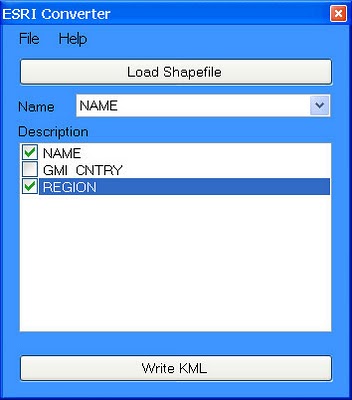
Simple but effective desktop tool (it works!) available for free download. Just point to the shp file you want to convert, select attributes to include in description field and press a button to run conversion. The only limitation is that you don’t have a choice in selecting colours.

Here is an example of generated output: World Borders in KMZ (1.14MB kmz file draped on Google Map).

To reduce the size of KML file for distribution or deployment just gzip it. It is easy done using Google Earth “save as” function. That is, open your KML file in Google Earth and when you save it, it will be automatically converted to a compressed gzipped format with kmz extension.

For custom conversions from shp polygons to KMZ format, such as splitting a large file with many polygons into smaller files with individual polygons only (eg. to convert a single 60MB shp file with postcodes into 2,500 individual KMZ files), or grouping of polygons into custom areas (eg. to create sales or franchise territories by amalgamation of postcodes), or converting shp polygons into a thematic map layer (eg. by assigning colours to polygons based on specific attributes, like for example electorates by political party holding the seat), you will need more advanced tools. I can help you with those conversions for a small fee. Here is a sample of a thematic KMZ file using a selection of Sydney suburbs. I also have various polygon based data in KMZ format for immediate delivery (eg. postcode boundaries, as used in aus-emaps.com postcode finder service). Don’t hesitate to ask!

Use case example: Create outlines of polygons and show in an embedded map on a website (using collection of free tools and services available from aus-emaps.com)
Steps:

1. Define vertex coordinates of custom polygon area using simple geocoder tool from aus-emaps.com (select “Point” option and click on the map, reposition markers as required, copy to Notepad).

2. Convert a list of points in csv format to shp file format using instructions provided in a recent post titled “Converting csv files into shapefile”.

3. Convert shp file into KML using tools introduced in this post.

4. Convert KML file into KMZ format using Google Earth (open KML file and “Save As”…) [optional step]

5. Upload KML/KMZ file to your server and reference its URL address in an aus-emaps.com free map service.

6. Embed the map in you web page using HTML’s iframe element.

The process is a bit convoluted, I admit. You could take a shortcut by pasting latitude and longitude coordinates directly into KML “shell” but you will need the right template for this in the first place. Using Google Map’s MyMap drawing and embedding functionality is a simpler option but you will not be able to create complex polygons (eg multi-part and/or doughnut type).

I am currently working on a public tool to generate custom polygons from administrative boundaries in a few simple steps. Coming up in 2011! But I will also have to put some though into creating a dedicated KMZ generation tool so you can do it all from a single web page… added to the list of “Things to do!”.

Mellor on Crossing The Line

“Whatever it takes,
that’s what I do.

–David Mellor (1963 – )

American groundskeeper

Director of Grounds, Fenway Park

Sales inspiration…

What if…

John and Abigail Adams had been more concerned with themselves and work/life balance than creating a democracy (if you’ve not seen the HBO miniseries – great stuff)?

What if… Abraham Lincoln (born on 2/12) had quit trying after having a business go under and losing his first local legislative race (and then 3 congressional races and 2 senatorial races)?

What if… Martin Luther King didn’t have a dream and played it safe (and didn’t travel over 6 million miles giving more than 2500 speeches). What if he thought he was too young to have an impact (he did everything he did in a life of only 39 years)?

What if… Gandhi, Teresa, Roosevelt, Ford, Disney, Walton, Gates, Winfrey, Jobs, Stewart, and Ash hadn’t stepped up and worked hard. (What if the thousands of people who supported them hadn’t?) What if your police, military, firefighters didn’t?

What if… No one pushed it, risked it, and pushed it again (and again)?

Be obligated to your world (your customers, your people). Be SalesTough.

(57 salesdays remain in the quarter. Get your 2011 printable salesdays.)

_____