Use Google Earth to estimate point-to-point links

AlphiMAX has recently updated their Point-To-Point Estimator to support a handful of new Google Earth features, and the result is pretty slick.

The tool already had a lot of great features in it, such as the ability to factor in temperature, terrain data and a variety of other factors.They added Google Earth support to it a while ago, via the Google Earth Plug-in, and it worked very well.

Then they recently added support for Google Earth 6, including the new 3D trees that were part of that release. For a P2P estimator, being able to see trees in the system is certainly an important part of it. The coverage of trees in Google Earth is still relatively small, making this feature somewhat less useful, but it’s certain to grow quickly in the future.

ptp.jpg

If you’d like to try it out for yourself, simply visit their site and dive in. It’s required that you have an account on their site for it to work, but otherwise you can get up and running fairly quickly. If you’d just like to see a resulting file, here’s a KMZ file of a test set of data.

Not many of us will need a Point-To-Point Estimator in our work, but for those that do the new enhancements to this program should be very useful!

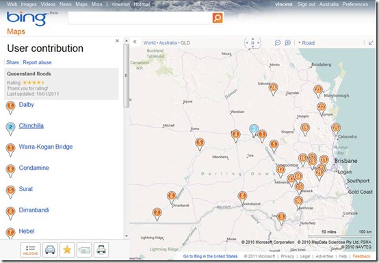
NineMSN & Bing Maps User Collections: Tracking the Floods

As many Australians and others around the world have their eye on the catastrophic floods in Queensland, Australia’s ninemsn used Bing Maps’ user collections to map out where the floods have occurred.

The collection is a great example of how online maps can be dynamic sources of visual information and context. Simply a list of cities affected by the floods cannot show just how dense of an area or how wide these floods affected.

ninemsn_homepage

ninemsn_collection

Our thoughts are with those in the Queenland’s area.

High school mashup: Digital History Class

We’ve long been admirers of the creative things educators and students do with SketchUp. Michael Hathorn is a high school teacher in Hartford, Vermont who teaches an innovative class that he describes as a “digital history” of their small town. They document White River Junction’s history by constructing 3D models of the town’s buildings and geo-locating them in Google Earth.

We’ve blogged about Hartford High before – and even found his work as an educator deserving of an official case-study video. Mike and five of his students presented at our Google Geo Teacher Institute last summer; since then, all of those students have gone off to college with a serious tool set of skills learned in Mike’s class.

This year, high school senior Michael Bateman created a video about his teacher’s class (above). In it, he and others explain why their project is so valuable in relation to typical high school classroom coursework.

There’s no doubt that engaging students can be difficult; it’s fun to see why Michael and his peers are so jazzed about this class. I’m also envious of his mad videography skills. Nice work, Mike and Michael.