Google Places is Adding Upcoming Events via Rich Snippets

Reader Matt Feldman of Yelo.us has pointed out a new feature in Places where Google is now integrating venue events into their Places Pages. It allows an individual to add the event data to their personal Google calendar and to “invite friends using the ‘Add to calendar’ link that appears alongside the event”.

Google has confirmed that they are adding these events to venues “in a few major cities across the globe, including New York, San Francisco, London, Paris (and others)” and this “information is based on data from rich snippets markup“.

Wcities and Zevents events use the RDFa based Open Graph data structure. Other events appearing on the National Museum of the American Indian Places page from NYC.com are sructured with the event microformat (vcard) formatting. Although it does not seem to matter which format you are using, if you are operating a local site that includes events and you want your event information included in Places, you should be formatting the data with rich snippets.

Overlays of Japan from the New York Times

We mentioned a great map from Hidenori Watanave that showed various information from Japan including flooding regions, power plant locations and other items.

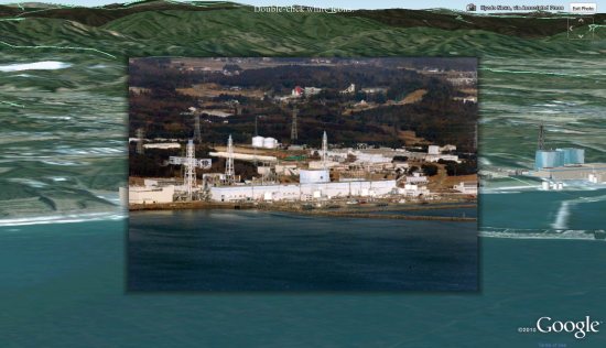
They’ve just released a new map, and I think it’s even more impressive! They’re calling it the Photo-Overlays of “The Aftermath in Japan” from New York Times, which places 30 different images from the New York Times as photo overlays in Google Earth. The photos were selected from this feature on the NYT, “The Big Picture” at Boston.com, Oregon Live, and more are being added all the time. However, as you can see in the image below, they’ve taken their time to line up the photos very carefully and the result is quite immersive:

aftermath.jpg

It also has a series of tools at the top of the screen to allow you to view some of the GeoEye imagery, turn on/off 3D buildings, view imagery from different dates, and to simply fly back out to the overview (quite useful while viewing an image).

While this is a fairly simple map to use, it’s been well-polished and is a great way to view the photos from this disaster.

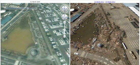
Also of note is a new map from SigActs that shows before and after imagery in Sendai. The interface is quite similar to the one from AnotherEarth that we showed you a few weeks ago, but this has been updated to show some great before/after shots.

sendai.jpg

Browsing around in there really shows the devastation and how much has changed in the area since the disaster struck.

New Maps domains in 11 countries in Middle East & North Africa

With the growing numbers of Internet users in the region, we noticed that a huge number of search queries have a geographic component. So, we’ve been working on providing rich, local geographic data to offer you the best local experience possible and today we are announcing the launch of local Google Maps domains for 11 countries across the region.

Now, Google Maps will be easily accessible from your local search domain in Algeria, Libya, Egypt, Lebanon, Jordan, Kuwait, Bahrain, Qatar, UAE, Oman, and Saudi Arabia. You’ll also be able to use it in Arabic as well as English and French for some countries. You can use Google Maps to search for a city, navigate your way around towns, or find a local business. This could be a Falafel place in Amman, a hotel in Cairo, or a restaurant in Jeddah.

Having access to maps on your local domain is more than just finding your way from A to B. There are many ways that businesses and individuals can contribute to making Google Maps in your country more useful and more accurate. Check out some of the following features:

Use My Maps to create your own personalized maps, for example a customized map of your favourite places in your neighborhood to share your experiences with others.

Maps in Algeria, Libya, Kuwait, Bahrain and Qatar have been made possible in large part by passionate users mapping their countries via Google Map Maker, which is available across the world in more than 180 countries and regions. Map Maker allows you to use your local knowledge to practically edit the entire map – from roads, businesses, parks, schools and more. Users have mapped out entire countries or just made their neighborhoods look stunning. Starting today Google Map Maker is now launched in Saudi Arabia and the United Arab Emirates.

It is also possible to include a Google map on your own website. You can display information – like a restaurant location or directions – on a Google map and embed it in your website using our Google Maps API. There are many great sites already using the API to share customized information on Google maps. For the developers and webmasters amongst you, the possibilities are endless.