Stories from Garmin customers


Every day, we hear from customers around the world who are using Garmin products to explore more or just add a little fun to their everyday pursuits. We also receive stories about how our products have helped save or change lives. Recently, our in-house video team captured a few of these stories, straight from the customers. Hear howForerunner helped Jason discovered a life-threatening heart condition.  How Garmin marine electronics helped Capt. Frank and his crew navigate stormy seas at night. How nüvi got Jeff to the hospital as he was having a heart attack. How Garmin avionics with Synthetic Vision technology guide organ procurement missions at all times of day and night, in all kinds of weather. And how our Rino two-way radio/GPS units help Heart to Heart International provide medical relief and humanitarian aid in response to disasters like the Haiti earthquake. Thank you to these individuals and our customers around the world for your faith in our products and for sharing your stories.


Google Earth: Cover the world in 3D buildings

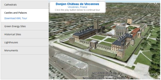
Google’s goal has long been to “add a 3D model of every building on the planet to Google Earth“, and with the help of you and I they continue to make strides toward that goal. In the five years since Google purchased SketchUp, users have contributed tens of thousands of buildings generated from SketchUp and by using tools such as Building Maker.

To help further expand the 3D coverage, Google has just unveiled the Your World in 3D site to give people a great place to access tools and information to help model their own buildings in 3D. They’ve compiled a ton of great resources including an events calendar, message forum, tips based on your level of use and a gallery of great 3D buildings around the world.

castles.jpg


If you’re not convinced that it’s worthwhile to spend time modeling buildings in 3D, Google has a video titled “Why create 3D models for Google Earth?” that tries to answer that question for you. They give some great examples of why 3D models can be useful for a city or organization:


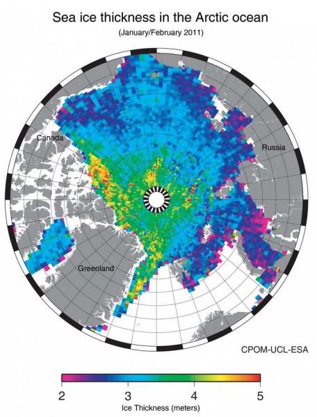
Map of Arctic Sea Ice


The European Space Agency has released a map of sea ice thickness in the Arctic based on observations by the CryoSat-2 satellite. “CryoSat measures the height of the sea ice above the water line, known as the freeboard, to calculate the thickness. The measurements used to generate this first map of the Arctic were from January and February 2011, as the ice approaches its annual maximum. The data are exceptionally detailed and considerably better than the mission’s specification. They even show lineations in the central Arctic that reflect the ice’s response to wind stress.” There’s also a map of Antarctic ice, but it’s preliminary.