Android: Video Chat on Your Phone

Sometimes, the expressions on a person’s face can mean much more than what they say. To help you stay in touch with your friends and family, we’re launching Google Talk with video and voice chat for Android phones.


You can now video or voice chat with your friends, family and colleagues right from your Android phone, whether they’re on their compatible Android tablet or phone, or using Gmail with Google Talk on their computer. You can make calls over a 3G or 4G data network (if your carrier supports it) or over Wi-Fi.

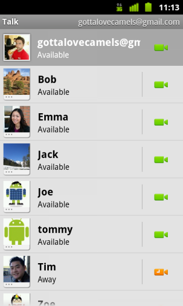
In your Google Talk friends list, a video or voice chat button will appear next to your contacts and you can simply touch the button to connect with them. Any text chats from the person you’re talking with will be overlaid on your phone’s screen so you can read them without having to leave the video. And, if you need to check something else, the video pauses automatically so you can go back to your phone’s home screen or another app. The audio will keep going even though the video has paused. Check out how this works:


Google Talk with video and voice chat will gradually roll out to Nexus S devices in the next few weeks as part of the Android 2.3.4 over-the-air update and will launch on other Android 2.3+ devices in the future. To learn more about using video and voice chat, check out our Help Center.

Maps Usability in Google IO

I was interested to watch the Google IO video above of Designing Maps Applications for Usability on Mobile and Desktop by Luke Mahé, Jez Fletcher, Justin O’Beirne as a while back I had a go at presenting my own map design ideas to developers. The other week I said I’ve stopped critically reviewing other people’s projects but when Googlers stand up and present about map usability I think some critical discussion is deserved. Here’s some thoughts in note form:


Stuff I liked:

  • Mobile vs Desktop: I don’t do much with mobile maps so it was interesting to have the differences between mobile and desktop discussed, I liked the idea that users on the desktop are ‘planning’
  • Rendering Speed: Fast response is an integral part of the UX (user experience), I haven’t really thought about this before except for very slow rendering maps so the discussion at 21 mins in was useful.
  • Emphasising: Justin’s points about how to use the GMaps API to demphasise uneeded map elements (30mins onwards) were smart and well made. I liked his examples of both good and bad maps.
  • White roads for routes I especially liked Justin’s point about making roads white for route focussed maps (36 mins), he’s right that it emphasises the route well.

Stuff I didn’t:

  • Placemark Clustering: At 14.29 Jez and Luke promote the idea that a placemark clustering visualisation is better than not clustering points. Strictly they’re correct as it is a way of tackling the ‘too many points’ problem but I think placemark clustering is flawed and not as good as other techniques. It should be said that this is my opinion – it may be that the clustering they show is actually a very effective technique, the proof would be a user test (which I will have a student looking at later this summer). My point is you shouldn’t promote an unproven technique.
  • Walk the Walk: It would have been good if the heat map Jez and Luke presented at at 14.58 had heeded Justin’s smart advice and faded the background so the mix of colors stood out. To be fair, I guess it wouldn’t have been straight forward to do this as it was a fusion tables map visualisation rather than a straight instance of the maps API but it can’t be that difficult.
  • Missing Topics: So they covered a lot of topics but there’s a of UX things that IMHO are relevant to developers that I discussed but which failed to get a mention: Layer control, Icon design (although they did point out that you should choose useful icons rather than just use the default markers), use of color, balloon design, map copy/micro-copy and introductions.

iFit Live Powered By Google Maps

Most people use Google Maps for reasons of pure function: Where is that new restaurant? How do I get there? How long will it take? We thought Google Maps could be used for an entirely different purpose – as entertainment while working out on the NordicTrack home fitness equipment.

People buy fitness equipment for a range of reasons – train for a race, lose weight or simply stay in shape – but a universal challenge for most is staying motivated and finding the time to exercise. In order to reach their goals, more people are turning to technology for time-saving, motivating exercise. We thought the visuals provided by Google Maps, combined with our fitness products and iFit website might be so compelling, consumers would have more fun and stay on track. Even if the only time you can squeeze in exercise is in the evenings when kids are asleep in or in the early, snowy mornings of winter before a long day at work, the iFit exercise equipment can bring the experience of exercising on varied terrain into your home.


For example, if you wanted to experience a run through San Francisco’s hilly terrain, you can go to the iFit website and draw a running route on Google Maps. When you get on one of our treadmills, such as the NordicTrack Elite 9500 Pro, the treadmill pulls up Google Maps on the screen with the newly drawn running route. The treadmill mimics the incline of the real world route you are running, thanks to the elevation service of the Google Maps API. The runner experiences a real life running route by seeing the runner’s location move about Google Maps with Street View images flying by a she reaches new personal records.