Memorial Day with Google Earth


On this Memorial Day, we offer you a few tools to help honor those who gave it all.

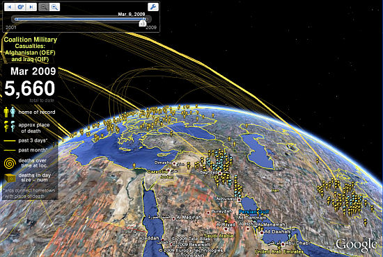
As we’ve done the last few years, we encourage you to check out Sean Askay’s Map the Fallen project. Using his KML file, you can learn about many of the people that have lost their lives in recent US military duty.


Map of the Fallen in Google Earth 

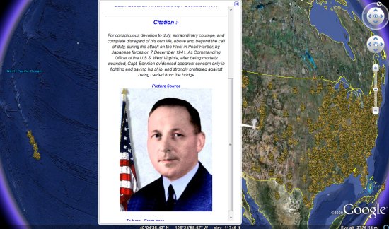
Another neat item to check out today is the US Medal of Honor collection that we first showed you in 2008. It was created by user ‘Up_The_Spurs’ from the Google Earth Community. You can download the KMZ and view the birthplaces, rank, organization, location of deed and citation for each winner.


medal-of-honor.jpg 

If you know of any other great Memorial Day resources for Google Earth, please leave a comment and let us know.

Garmin Super Bowl Commercial 2007

Garmin Super Bowl Commercial. Aired Sunday February 4th, 2007 during Super Bowl XLI


http://www.youtube.com/v/KL3ccJDplzs?f=videos&app=youtube_gdata

Space Archeologists discovering ancient tombs in Egypt


While we’ve often referred to them as “Armchair Archeologists“, Dr. Sarah Parcak is doing similar work by finding thousands of important ancient settlements through the use of infrared satellite imagery.


parcak.jpg 

According to Gizmodo, the satellite that captures the infrared imagery is accurate to one meter, and makes pyramids, tombs and settlements easier to spot even if they are completely buried. Because ancient Egyptians used mud brick, it is much denser than the soil around it and can be picked up with infrared satellite imagery.

She recently traveled to Egypt to during which they excavated a 3,000-year-old house, and the outline of the structure matched her imagery almost exactly! This was great validation of the work she’s been doing.

You can read more about what she has done and her future plans on the BBC website.

Stefan at Ogle Earth has dug into this story as well, and has created a nice file to use for comparison purposes. Grab his KMZ file to see a comparison between some of Dr. Parcek’s imagery and the base Google Earth imagery for the same area.