This was a question that came up at the cloudhack event last weekend – when you create a new instance of the Bing Maps AJAX control, you specify the centrepoint of the map in latitude and longitude coordinates, using the center property in the viewOptions passed to the constructor. For example:
[php]
var map = new Microsoft.Maps.Map( document.getElementById("mapDiv"),
{ credentials: ENTERYOURBINGMAPSKEY,
center: new Microsoft.Maps.Location(54, -4),
mapTypeId: Microsoft.Maps.MapTypeId.aerial,
zoom: 12
});
[/php]
(You can view more information on the viewOptions parameters here: http://msdn.microsoft.com/en-us/library/gg427628.aspx )
However, what if you want to create a map centred on an address instead of a latitude/longitude coordinate? This seems like a fairly simple, common request, so I was a bit surprised to find that none of the Microsoft method reference guides nor any of the “interactive SDK” sites provide an example showing how to do this.
Fortunately, it’s not too tricky to do so, for the benefit of everyone other than those teams at the cloudhack event who asked me, I thought I’d write it up here 
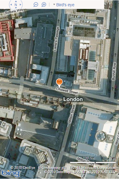
First, you need to geocode the address into latitude and longitude coordinates (using theREST Locations API is the easiest way to do so direct from javascript). Then, in the jsonp callback function that is executed after the geocode service returns its results, create and centre the map on the returned coordinates. Here’s an example (note that you will need to replace ENTERYOURBINGMAPSKEY here with some valid credentials, or else the call to the REST service will fail and the map will not be created):
[php]
<!DOCTYPE HTML PUBLIC "-//W3C//DTD XHTML 1.0 Transitional//EN" "http://www.w3.org/TR/xhtml1/DTD/xhtml1-transitional.dtd">
<html xmlns="http://www.w3.org/1999/xhtml">
<head>
<title></title>
<meta http-equiv="Content-Type" content="text/html; charset=utf-8" />
<script type="text/javascript" src="http://ecn.dev.virtualearth.net/mapcontrol/mapcontrol.ashx?v=7.0"></script>
<script type="text/javascript">
var map = null;
var credentials = "ENTERYOURBINGMAPSKEY";
function GetMap() {
// Define the address on which to centre the map
var addressLine = "54 Chiswell Street"; // Street Address
var locality = "London"; // City or town name
var adminDistrict = ""; // County
var country = "UK"; // Country, obviously
var postalCode = "" //Postcode
// Construct a request to the REST geocode service
var geocodeRequest = "http://dev.virtualearth.net/REST/v1/Locations"
+ "?countryRegion=" + country
+ "&addressLine=" + addressLine
+ "&locality=" + locality
+ "&adminDistrict=" + adminDistrict
+ "&postalCode=" + postalCode
+ "&key=" + credentials
+ "&jsonp=GeocodeCallback"; // This function will be called after the geocode service returns its results
// Call the service
CallRestService(geocodeRequest);
}
function GeocodeCallback(result) {
// Check that we have a valid response
if (result && result.resourceSets && result.resourceSets.length > 0 && result.resourceSets[0].resources && result.resourceSets[0].resources.length > 0) {
// Create a Location based on the geocoded coordinates
var coords = result.resourceSets[0].resources[0].point.coordinates;
centerPoint = new Microsoft.Maps.Location(coords[0], coords[1]);
// Create a map centred on the location
map = new Microsoft.Maps.Map(document.getElementById("mapDiv"),
{ credentials: credentials,
center: centerPoint,
mapTypeId: Microsoft.Maps.MapTypeId.aerial,
zoom: 18
});
// Add a pushpin as well
var pushpin = new Microsoft.Maps.Pushpin(map.getCenter());
map.entities.push(pushpin);
}
}
// This is a generic function to call a REST service and insert the JSON
// results into the head of the document
function CallRestService(request) {
var script = document.createElement("script");
script.setAttribute("type", "text/javascript");
script.setAttribute("src", request);
var dochead = document.getElementsByTagName("head").item(0);
dochead.appendChild(script);
}
</script>
</head>
<body onload="GetMap();">
<div id=’mapDiv’ style="position: relative; width: 400px; height: 600px;">
</div>
</body>
</html>
[/php]
Here’s the resulting map:

