Deep diving with Richard Branson

We’ve mentioned Richard Branson on GEB a few times in the past, such as his “Project Virgle” a few years ago, but I believe this is the first time he’s put together an official venture with Google Earth.

Yesterday he announced the launch of Virgin Oceanic, to explore “the last frontiers of our own Blue Planet: the very bottom of our seas”. Over the next few years they’ll be traveling to the very deepest points of the ocean, including a planned venture to the bottom of the Mariana Trench — 36,201 feet below sea level!

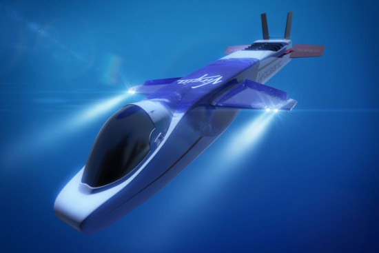
They’ll be traveling in an 18ft long, $17 million sub that resembles an aircraft:

virgin-sub.jpg

Even better, data from the dives will be captured and added to Google Earth. Details haven’t been released, but I would certainly expect new imagery and videos, and perhaps more additional detailed terrain relief for those deep areas. (Frank Taylor adds: 3D tracks of their dives could be shown in GE too!)

Follow the Mission Blue expedition to Salas y Gomez

While many of us would like to embark on a voyage across the ocean, we can’t all be Frank Taylor. Fortunately, Google Earth provides a great way to explore places virtually, such as with the latest installment in the “Mission Blue” series.

Last month, we showed you Mission Blue’s tracking of the gulf oil spill recovery effort. This month, they’re heading east from Easter Island to the tiny island of Salas y Gomez in an effort to do some research in the largely unexplored waters around the island.

salas.jpg

As with the gulf spill mission, they’re providing updates in a variety of ways. You can track it by finding the blue ship icon near Easter Island (be sure the “Places” layer is turned on), by downloading this KML file, or you can track them in the Google Earth Gallery using the Google Earth Plug-in.

Salas y Gomez was updated in the most recent imagery update, featuring imagery that is just a few weeks old. It’s a bit fuzzy, but it’s much better than what they used to have there. To check out the island for yourself, you can fly there using
this KML file.

For more, check out the full entry on the LatLong Blog or read stories from the crew on the Mission Blue News Watch blog.

360 Panoramas Now Part of Google Earth Photos Layer

Google has upgraded the Photos layer in Google Earth to not only include the millions of geo-tagged photos from Panoramio, but also to include 360 degree panoramas from 360cities.net. The 360 photos were previously viewable in Google Earth if you opened the Gallery layer folder and turned on the 360Cities layer. But, now everyone can find the panoramas with the default Photos layer. The regular 2D photos still appear as little blue icons as you zoom into a place. Now, if 360 panorama photos are available for that place, you will also see little red square icons as well. Click on a red icon and you’re presented with a 2D view of that location in the pop-up window and you can click the photo to fly into the 360 panorama right in Google Earth.

gebora360.jpg

I’m a big fan of 360 panoramas which give you a full immersive experience of a photo location – you can look in all directions, including up and down. During our first year of the Tahina Expedition I have produced many 360 panoramas of places in the Caribbean, the Panama Canal, Galapagos, the French Marquesas, Bora Bora, Tonga, and more (see recent 360s of Tonga, see all of the panoramas for Tahina Expedition). Now everyone can find 360 photos like these, and those done by thousands of photographers around the world right in the Photos layer.

I’m thrilled to see 360 panoramas, and 360Cities.net, get more visibility. Jeffrey Martin, who started 360Cities, says that there are more than 60 thousand 360 images in the new Google Earth layer. Congratulations Jeffrey! Kudos to Google for making these photos more accessible! I hope they’ll take the next step and add them to the Photos layer in Google Maps as well.

See LatLong blog post about the layer changes.gebora360.jpg