A Google Map Maker Roundup

Google announced today that Map Maker is now available for the United States; the tool that allows users to add contributions to Google Maps had, I thought, been targeted at countries where Google lacked map data, but it appears that user contributions are welcome in countries with existing data — once they’ve been reviewed.

So it looks like a Map Maker vs. OpenStreetMap conflict is shaping up. Last week, Mikel Maron accused Map Maker of copying OpenStreetMap’s model and exploiting freely made contributions in a way that benefits Google, in that the resulting data is not freely available; moreover, he says,

Corporations should not be the stewards of a public resource, and a potentially controversial public resource. Compare Gaza in OpenStreetMap and Gaza in Google for just one example of why this is a bad idea. We’re approaching a situation where a corporation is becoming the decision maker on international borders. Wait, did you think the UN or other international forum was supposed to have some role in these kind of things? Nope, Google is getting UN data too.
Sessions updated for Google I/O 2011!

This post is by Monica Tran. Monica comes to Google by way of the Developer Marketing team, primarily focused on Google I/O and our international Developer Days. As it is written in To Kill a Mockingbird, “Thus you’ll come to know Monica whose head teemed with eccentric plans, strange longings, and quaint fancies.” – scottk

Monica Tran in typical attire

From our Last Call for Google I/O contest to I/O Extended viewing parties all over the world, we’re super duper extra excited to bring you even more surprises at Google I/O in 2011. Starting this week and counting down to May 10, we’ll be bringing you the latest on Way After Hours, the Developer Sandstorm, Android for Goodness Sake, I/O It’s Alive and a massive number of other things with cool names.

To kick off April, we’ve added NEW! sessions, covering web technologies of the future. We think this new lineup of speakers, tracks, and sessions will arm you with the tools you need to become tomorrow’s innovators and pioneers of the Internet revolution. Check out the Google I/O page and hit our guestbook to let us know what you think.

For those of you unable to join us in person on May 10 – 11, we will be harnessing the power of the interwebs to bring you real-time video footage of the keynotes and recorded videos of all sessions. Viva le web-volution!

Please pardon our dust–the site is currently under construction and you might find it acting up. We promise to get it fixed by tomorrow.

CyberCity3D: Modeling 3D buildings using Satellite Imagery

CyberCity3D has been doing a lot of cool stuff with Google Earth lately. Last year we showed you their Hidden Treasures of Los Angeles map, and a few months ago they showed off some of their new GeoGames that provide an interactive experience for the user.

Their latest announcement is going back to their roots — 3D modeling. They’ve announced today that they’ve developed a system to produce 3D buildings from stereo satellite imagery, in a way that be scaled to a fairly large region.

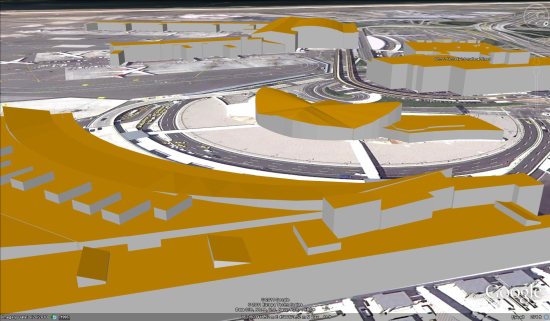
As an example, here is a photo of their model of JFK International Airport, which you’ll see includes some rather detailed architecture.

jfk-yellow.jpg

The only real downside to this is that their system doesn’t yet put textured images on the buildings. Hopefully that is something they can figure out in the future. If you’d like to see their model of the airport yourself, you can download this KMZ file.

CyberCity3D has created hundreds of thousands of 3D buildings for Google Earth, and this technique may help increase the speed of that. If that can figure out a way to automatically texture the building, or least give users an easy way to texture it themselves, we could see substantial increase in 3D building coverage over the next year.