Use Ground-Level View to complete a 3D maze

GEB reader ‘Will from the UK’ has sent us another cool find — a 3D maze! The grounds of the Hampton Court Palace in London include a lot of greenery, and this maze is part of it.

3d-maze.jpg

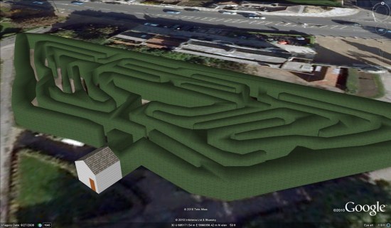
This would have been pretty neat in any case, but it’s made much cooler by the new “Ground Level View” in Google Earth 6. You can give it a try by using this KML file. If you use a Space Navigator, try to fly through it. If not, then grab the Street View pegman from the navigation tools and put him in the maze. This will shift you to “Ground-Level View” mode, and then you can use the arrow keys to work your way through the maze.

The lack of collision detection in Google Earth means that you can go right through the shrubs, which makes it a bit difficult to work your way through. Still, it’s a pretty neat find! If you get stuck, Will created this simple KML file that shows the path to the center.

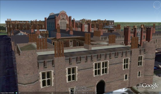
While you’re there, be sure to check out the Palace itself. It possibly has the most chimney stacks of any building in Google Earth — there are a ton of them!

palace.jpg

Were you able to complete the maze? Have you discovered any other locations that are much more interesting now thanks to the “ground level” mode?

WikiLeaks around the world

WikiLeaks has been all over the news for the past few weeks. As politicians are quickly finding out, fighting something like WikiLeaks doesn’t stop it — it simply causes it to spread. Thanks to the big crackdown against them, their site has been mirrored all across the globe.

Laurence Muller spent some time tracking down the locations of the mirrors (with some useful tools) and built an excellent visualization of them.

wikileaks.jpg

His technique for creating this was pretty impressive. He first found the list of mirrors that WikiLeaks provided, then ran it through GeoLite City which resolved the mirrors to actual locations. He then wrote a PHP script to turn the location into latitude/longitune, and then to compile all of that into a KML file. Details about all of that work can be found on his site. Nice work Laurence!

To see it for yourself, you can visit one of the following pages that have the data loaded in the Google Earth Plug-in:
Wikileaks Edges only
Wikileaks Nodes
Wikileaks Nodes with labels

Alternatively, you can download a KML file that has all three versions loaded, or watch the video below that he put together.

(via ReadWriteWeb)

Forgotten Spaces Google Earth Tour

Forgotten Spaces is an architectural competition that suggests new uses for the forgotten spaces around London. As a Londoner and appreciater of architecture it caught my imagination and I went to see an exhibition about it over the weekend at the National Theatre.
I enjoyed it but was frustrated by the lack of a decent overview map both in the exhibition and on the web: I wanted to see about what the neighbourhoods were like around the locations. It occurred to me that they could have used Google Earth really well in presenting the competition so I created a Google Earth tour of three of the entries to illustrate the idea.
It isn’t very slick as I’m short on time but I think its good enough to shows some ideas that I discuss below:
A few points to make about the tour:
  • Quick!:Whole thing took me 2 hours, including a fair amount of time spent locating where the spaces were. In a day I could create something slick looking.
  • Streetview: You can get streetview in Google earth (they have their own layer), by copying the photo spheres into the tour folder you can incorporate them in the tour as I have. Gives you great local context.
  • Viewing Elements: I imported the photos into Google Earth as photo overlays – you just drag and drop them from windows explorer into the main GE window. Its very quick but you cannot enter the viewing mode in the tour which is a pain, same with the streetview photo spheres. On a tour you can pause the tour and double click the elements and you’ll be able to enter photo viewing mode, have a go to see what I mean.
  • Avoiding Cyber Sickness: If you throw the camera about wildly its possible to induce cyber sickness in viewers and even if you don’t do that, wild camera moves confuse users, they don’t know where they are. You can see that I tend to zoom and pan in and out whilst keeping the view north-top vertically-down. If I want a tilted view with a non north bearing I do that when zoomed right it, trying to keep the relevant screen elements in view as I do so. Zooming out, I straighten up the view before zooming out.
  • Overview Map/relative locations: To help users build up a cognitive map of where all the elements are (so they can effectively explore afterwards) I start and end with an overview of all the locations and between locations fly up to this overview. When panning from place to place I keep elements in view so users can get an idea of their relative locations.
This post is unofficial and not condoned by RIBA, I have used their copyright images for educational purposes and also as a critique of the web presentation of Forgotten Spaces.