Map pinpoints low cost regions for holiday travel


In NSW, South Coast offers better prices than tourism regions north of Sydney (which tend to be 10-30% more expensive). In Victoria, Gippsland offers the best value for coastal regions and in South Australia, Yorke Peninsula north of Adelaide is cheaper that Fleurieu Peninsula (which is 35% more expensive).

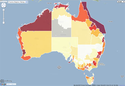
The researchers examined average takings per night by accredited accommodation service providers in each tourism region around Australia and mapped out the results. The outcome is a colourful map matrix that highlights regions with both the cheapest and the most expensive accommodation. Since accommodation accounts for a significant proportion of overall travel expenses, the ranking presented in the report is indicative of the relative cost of holidaying in the particular location.

On a State and Territory basis, Tasmania has the cheapest accommodation while the Australian Capital Territory is comparatively the most expensive ($128 and $163 respectively).

The title of the cheapest region in Australia goes to Victoria’s Wimmera tourism region, which has an average accommodation cost of just $83.82 per night. Close second is South Australia’s Yorke Peninsula ($85.36), followed by Northern Territory’s Barkly ($87.98), Victoria’s Upper Yarra ($90.48) and Outback NSW ($93.14).

Not surprisingly capital cities and large metropolitan areas are amongst the most expensive travel destinations in terms of tourism accommodation. However, the title of the most expensive in Australia goes to the Great Barrier Reef tourism region, which has an average accommodation cost of $287.79 per night. The second most expensive is Kangaroo Island in South Australia ($205.52 per night). These are followed by another favourite Queensland location, the Whitsundays ($203.51), Victoria’s Spa Country ($195.00) and Western Australia’s North West Tourism Region ($186.48).

Since the report is based on June 2010 quarter data and as such visitors to the regions may find the real prices much higher at this time of the year. However, the relative rankings of tourism regions will hold true.

NSW traffic conditions map

Road Traffic Authority (RTA) in NSW has stared publishing up to the minute information about traffic conditions in Sydney as well as in NSW regional areas. The coverage and extent of information is quite comprehensive and it is served in two formats to suit individual preferences: as an interactive map with continuously updated information, and as a text list (with sort function to enable arranging information according to update time, type of incident or its location). A separate window lists 67 live traffic cameras strategically located across Sydney’s road network, with images refreshed every few minutes.

I find map option the most informative as it displays all the data in geographic context. Information on the map is refreshed automatically with update time clearly marked. Auto update can be turned off if required and users can customise the list of information items for display on the map.

Live updates include information on accidents, scheduled road works, major events, fires, floods and Alpine conditions. There is an option to add traffic flow overlay for Sydney provided by Google as well as locations of live traffic cameras and temporary message signs.

Journey planner, utilising Google driving directions script, is part of the application. The map comes with a comprehensive list of points of interests that are very handy for planning a trip. These include: bike parking areas, heavy vehicles checking stations and rest areas, locations of Safe-T-Cams, general rest areas and RTA Motor Registries. Travel routes can be filtered to avoid incidents or road works on specific dates and can be saved for future reference.

RTA provides RSS feeds of the information on region by region basis. However, despite the push by Federal and State governments to liberate access to data generated by their agencies under creative commons licence, RTA is not letting developers to use its information for value added services and derived products. It is strictly for personal use although, embedding of the entire application in third party websites is allowed. A comprehensive widget customisation tool is provided as a part of the application, with easy to follow instructions.

Overall, this is quite a comprehensive information source, with attractive multi tab design and extensive range of features. The mapping functionality of the application is built with Google Map v2. Mobile version would be a great extension.

Geo at Google I/O 2010

(Cross posted from the Google Code Blog)

Thanks from the Geo API team for a making Google I/O a great event yet again! We really look at I/O as being for developers by developers, so each year our API engineering team makes the pilgrimage from Sydney, Australia to personally present the new APIs and features they’ve spent most of their time working on. These features and new APIs are, in most cases, requested by the Maps API community so it’s a real thrill for us to deliver on these requests in person.

For those that were unable to make it, we’ve got you covered! The following is a summary of the key Geo API announcements that were made, along with a link to each session page that (as of today) now includes full videos and presentation materials. To bookmark all Geo sessions, use this YouTube playlist. Refill the coffee and get comfy!

As our new and existing Maps APIs continue to evolve we would love to stay connected with you. Be sure to join our Google Group, check out the Geo Developers Blog or follow @GoogleMapsAPI on Twitter!

Posted by Mike Pegg, Google Geo API Team