Bing Maps – CachEye

Bing Maps – CachEye


CACH’EYE is a free personalised geocaching map service based on a Bing Maps application. Each user can define the content of his personal cachemap. Cache data are imported from Pocket Queries, from GPX- / LOC-Files or are exported from Geocaching Swiss Army Knife (GSAK) and visualised in an easy-to-use interactive map.

CachEye BING Maps OSM Layer
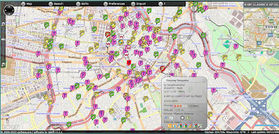
Clear, creative mapping for geocaches around the world.

Version 1.1 has many new features

  • Caches and additional waypoints now can be imported into the map directly from your Pocket Queries using the PQ-ZIP-File or still by using a GSAK-macro (as in V1.0), Up to 3000 caches plus waypoints may be displayed.
  • A single cache may be imported and visualized on the map via a GPX- or LOC-File.
  • Caches and additional waypoints now are associated to each other. With Focus/cache the map highlights and zooms to all waypoints of a specific cache.
  • ToDo-Lists assist you in quick and easy route planning. Todo-lists are named and you can maintain several lists.
  • Now you may move solved “Mysteries”, “Multicaches” and “Other Caches” to corrected coordinates on the map in case you did not import this cache from GSAK.
  • Openstreetmap also can be used as the basemap.
  • Measure distance tool
  • Altitude display (approx.) in Cache/Waypoint/Marker Popup
  • Metrics (km/miles) may be changed in account settings / information.
  • Displays waymarks on the map for GSAK-based datasets
  • Invoke the “Log Your Visit” page directly from within the map
  • Better appearance on 800×600 screen resolution

Map Demo:
http://demo.cacheye.org/

More information on CachEye

Crime Maps England & Wales

Crime Maps England & Wales

Recorded crime in England and Wales on Google Maps – find what crimes have been committed in their neighbourhoods.

The map shows crime mapped to “an anonymous point on or near the road where they occurred.” NOTE: Individual addresses are not pinpointed on the map.

To search for crime in an area users can enter a postcode or an address. The map will then display the crimes committed in a radius of the submitted location. The maps include a pretty neat marker clustering system and the number of crimes are also broken down by category.
Crime Maps  England & Wales
Crime Maps for England and Wales – to Street Level – Search by postcode, town name or street.

Example:
http://www.police.uk/crime/?q=Oxford,%20Oxfordshire,%20UK#streets

Built on the API – http://www.police.uk/api/docs/

Source:
Google Maps Mania
http://googlemapsmania.blogspot.com/2011/01/uk-launches-national-crime-map.html

Interesting related post on the Guardian
http://www.guardian.co.uk/technology/2011/feb/02/uk-crime-maps-developers-unhappy

The Art of Maps: Map of Svecia and Norvegia from Atlas sive Cosmographicae by Gerardus Mercator (1595)

Atlas sive Cosmographicae by Gerardus Mercator (1595)

The Fleming Gerard Mercator (1512-1594) is rightfully regarded as the most important scientific cartographer of the Renaissance. With two contemporaries, the geographer Abraham Ortelius and the printer and publisher Christoffel Plantijn,he is considered the father of commercial cartography in the Netherlands.Even during his lifetime his maps, globes and atlases found their way all over the world.Mercator established his reputation mainly through his new projection method. The meridians and parallels are positioned at right angles to each other.If the distances between the meridians are equal, they progressively become larger between the parallels from the equator to the poles.This is why the latitude becomes wider the closer you get to one of the poles and why the part of the Earth in the upper latitudes exhibits excessive proportions.The advantage of this method was the far greater degree of certainty and accuracy in determining shipping routes.In 1585, Mercator published the first three parts of his own book of maps in one volume,which he called Atlas.The second edition appeared in 1589, with the addition of a fourth part. The first complete edition was compiled by his heirs in 1595 one year after his death.Walter Ghim,mayor of Duisburg the city where Mercator had lived for a long time,wrote the accompanying Mercator biography.It was the first time that a book of maps was referred to as an Atlas.Commercially speaking,however,the Atlas was not a success thanks to formidable competition from the Theatrum orbis terrarum by Abraham Ortelius,published in 1570,which by the end of the century had been reprinted more than twenty times.

The Art Of Maps:

The Art of Maps: Map of America from Atlas sive Cosmographicae by Gerardus Mercator (1595)
The Art of Maps: Europa Delineata juxta Obfervationes Excellorum – Vindel 1760
The Art of Maps: PIRI REIS MAP
The Art of Maps: Map of Europe from Atlas sive Cosmographicae by Gerardus Mercator (1595)
The Art of maps: John Speed: Asia with the Islands adioyning described, the atire of the people, & Townes of importance, all of them newly augmented . . . 1626
The Art of Maps:Johann Baptiste Homann [California as an Island]
The Art of maps:Matthias Quad – Map of North America 1593
The Art of Maps: Americae Nova Tabula
Sightseeing Map Locations Bulgaria
The Art of Maps: CORNELIS DANCKERTS Nieuw Aerdsch Pley MAP