Monetize your Maps API v3 application with AdSense for Maps

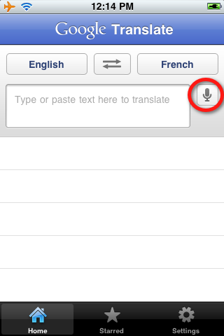
Many existing websites that use the Google Maps API also use Google AdSense to monetize their site. AdSense uses the content of pages to determine the best ads to show for that audience. However there is valuable additional context offered by the location of the map. When a map is centered on the Napa Valley for example, ads relating to wineries may be more relevant.

In response to this we are happy to bring AdSense for Maps to Maps API v3. The Maps Ad Unit overlays a set of AdSense ads on the map, in any of the supported formats. You can control where on the map the ads are placed, and the ads shown are based on the current map location. It is a simple way to monetize your maps with unintrusive and relevant advertising.

To use the Maps Ad Unit you must have an AdSense account that is enabled for AdSense for Content. If you do not have an AdSense account, you will need to sign up by filling in this form. Once you have received your AdSense publisher id, take a look at the documentation to see how to add the Maps Ad Unit to your Maps API application. As always if you have any questions or need help, we recommend posting to the Maps API v3 forum.

You may also notice that we’ve given the map type control and Google logo a refresh in this release. The new map type control is more compact and extensible, easier to use on touch screen devices, and consistent in look and feel with our other controls. We hope you like it!

Geo-modeler and Sydneysider Peter Olsen

Retired software engineer Peter Olsen discovered SketchUp shortly after it was acquired by Google in 2006. He published his first model to Google Earth’s “3D Buildings” layer in July 2008. Two and a half years later, he has 68 buildings in Google Earth—some as far away as Italy and Peru.

Peter is a Sydneysider, so it’s not surprising that he focused his initial geo-modeling activity in his home town. He’s modeled several of the city’s most visible buildings and structures, including Luna Park, the Anzac Bridge, Pyrmont Bridge and the Sydney monorail.

In addition to the 3D model, he also created a fully animated version of the Luna Park Ferris Wheel (seen above) complete with moving shadow, using a technique pioneered by Barnabu in his London Eye animation.

Peter noticed that many of Australia’s special places had not been modeled, so he expanded his reach by modeling Australia’s unique underground Parliament House building in Canberra, Australia’s capital city.

Like any artist, Peter continued to perfect his skills by tackling more complex geometric structures. Peter says:

“I never lost my interest in architecture and throughout my years in computing I dreamed of the day when a program would be invented that would allow the construction and manipulation of a 3D model of a building. The capability was naturally developed eventually, in the form of very expensive CAD programs. Imagine my absolute delight when I stumbled across a brilliant free program called Sketchup. My years of dreaming had suddenly become a reality.”

In 2010, he modeled one of the most challenging places on earth: Machu Picchu.

Many geo-modelers estimate building heights and other details from photographs. Not Peter. He takes great pride in the accuracy of his work as his description in the Machu Picchu model indicates: “The model contains every building, terrace and staircase and is accurate to less than 10cm (4″) over most of the site.” Peter insists that he likes his “models to be absolutely accurate reproductions, not just approximate representations.”

During email discussions about some of Peter’s Sydney models, I jokingly mentioned that the Google Sydney building had yet to be modelled. Four hours later he forwarded a reasonably accurate model of the building based on a few scant photos of the recently-completed building that he found on the web.

I appreciated his efforts and and invited Peter to lunch at the Google office. After lunch Peter spent 6 hours painstakingly measuring and photographing every nook and cranny of the building (I guess he liked the food!). A week or so later he forwarded his latest work of art, which has since been incorporated into the 3D buildings layer. Peter says that his “sense of amazement at the results that can be achieved with SketchUp has not diminished since the day I started work on my first model.”

Introducing the Google Translate app for iPhone

Back in August 2008, we launched a Google Translate HTML5 web app for iPhone users. Today, the official Google Translate for iPhone app is available for download from the App Store. The new app has all of the features of the web app, plus some significant new additions designed to improve your overall translation experience.

Speak to translate
The new app accepts voice input for 15 languages, and—just like the web app—you can translate a word or phrase into one of more than 50 languages. For voice input, just press the microphone icon next to the text box and say what you want to translate.

Listen to your translations
You can also listen to your translations spoken out loud in one of 23 different languages. This feature uses the same new speech synthesizer voices as the desktop version of Google Translate we introduced last month.

Full-screen mode
Another feature that might come in handy is the ability to easily enlarge the translated text to full-screen size. This way, it’s much easier to read the text on the screen, or show the translation to the person you are communicating with. Just tap on the zoom icon to quickly zoom in.

And the app also includes all of the major features of the web app, including the ability to view dictionary results for single words, access your starred translations and translation history even when offline, and support romanized text like Pinyin and Romaji.

You can download Google Translate now from the App Store globally. The app is available in all iOS supported languages, but you’ll need an iPhone or iPod touch iOS version 3 or later.