The news earlier this month that MapQuest had added Canada (among other countries) to its suite of Open MapQuest sites — was something I’d been dreading for some time. I’ve been making contributions to OpenStreetMap’s Canadian maps for a year, adding my own GPS traces here in western Quebec as well as New Brunswick, and tracing imagery in at least five provinces (especially Manitoba, where I grew up), and I can tell you: Canada’s OSM maps are just not ready for prime time.
The basic problem, as I see it, is that there are too few volunteers trying to cover too much territory. As a result, I’ve noticed several critical issues with the state of Canadian map tiles and how they’re being edited.
- Vast tracts of Canadian territory are blank or have only the most basic coverage — even urban areas with high-resolution imagery available for tracing, and this was even before the Bing imagery dramatically expanded the territory that could be traced. (Regina, Saskatchewan’s capital, still has streets missing despite the availability of imagery.)
- Some areas are traced in a crude or sloppy manner, as though the streets were drawn at several zoom levels too far out, even though higher-resolution imagery is available. (This leads other contributors to believe that an area is already done, and leave it uncorrected.)
- Users who import open geodata from CanVec do so in a sloppy manner — not connecting to existing ways, not keeping way classifications consistent (e.g., the same highway is tagged as primary on one tile, and secondary on another — see CanVec imports in New Brunswick).
- Even more problematic: CanVec imports that replace existing edits, or even double existing streets without removing what they replace (for example, the Municipalité du Pontiac, northwest of Ottawa). These edits sometimes substantially degrade some of the data quality: for example, by importing older data that wipes out a newly built highway (which happened last year on Highway 417 between Arnprior and Ottawa, and Highway 7 between Carleton Place and Ottawa).
Which is to say that even though there is a tremendous amount of work still to be done, including a lot in what I suppose could be called “virgin territory,” Canadian OSM contributors have to spend a lot of time overwriting and correcting each other’s work.
Just last Saturday, I discovered that the edits I made in Aylmer and Hull — suburbs of Gatineau, Quebec that I know very well, because I pass through them every time I go to Ottawa — had been replaced by a batch import from CanVec. The CanVec data was more recent than the Bing imagery I had traced, which dated from 2006, and included street numbers (addr:interpolation), which is handy. But it removed a lot of human intelligence that I had added to the existing streets, such as pedestrian crossings, traffic lights, and turning circles. It also obliterated service roads, and turned all streets into highway=unclassified instead of residential, tertiary, or secondary, and divided highways into two-way streets. And any areas that had shared a node with a street way were now bollixed up.
The CanVec data was also less precise than the Bing imagery for the area, which is crazy high resolution: the curves I had traced were far cleaner and more accurate than the CanVec data, and the CanVec data had some bizarre routings that weren’t just a little bit off from the aerial imagery. Streets that I knew were proposed or under construction, because I surveyed them myself, were marked as completed.
In other words, a big mess to revert, or to fix: the CanVec data had some useful information to add to the map — but not at the cost of erasing hours upon hours of existing work. My work. I was pissed, and complained on Twitter (which started a lively discussion on OSM talk mailing list), to the contributor who did the import (who meant well, I think, but goofed up: by trying to solve a small problem, he created a hundred new problems), and to the talk-ca mailing list.
My basic point was, and is, the following: that you’re not going to get local people to contribute to OSM if they believe that their edits are going to be wiped out by the next person to import a pile of data.
And OSM can’t afford to discourage Canadian contributors, particularly those who can add local information, rather than generic vector data that Google Maps already uses. There’s just too much to do, and not enough of us doing it.
And that’s why I was dreading the MapQuest connection even before my Aylmer/Hull edits got nuked. When OSM announced the U.S. version of open.mapquest.com, I knew that it wouldn’t be long before a Canadian version would be coming. I thought to myself: This is too soon. We’re not ready. And I thought about all the places that still needed fixing up — I didn’t know how to import CanVec or use JOSM, but I could still think of whole towns that needed someone to walk their streets, vast tracts of imagery that needed tracing …
… and then I stopped myself. What the hell was I thinking? Why was I letting MapQuest and Bing, with their contributions, rush me into spending hours of volunteer work on OSM? Their move toward OSM was strategic: use open mapping data as low-cost alternative to Navteq or Tele Atlas. Why I should I work like mad, for free, just to support their business strategy?
OSM’s Canadian maps have a long, long way to go before they’re useable. They need more volunteers working on them, and a way to ensure that the volunteers importing CanVec data, the volunteers tracing high-resolution imagery, and the volunteers running around with GPS receivers aren’t stepping on each other’s toes. That’s going to take some time and effort. My best guess is that it’s going to take several years. (AOL and Microsoft may well be disappointed to hear that.)
I’m looking forward to OSM’s Canadian maps getting into very good shape. I’m looking forward to helping get them into good shape. But right now, they’re terrible.
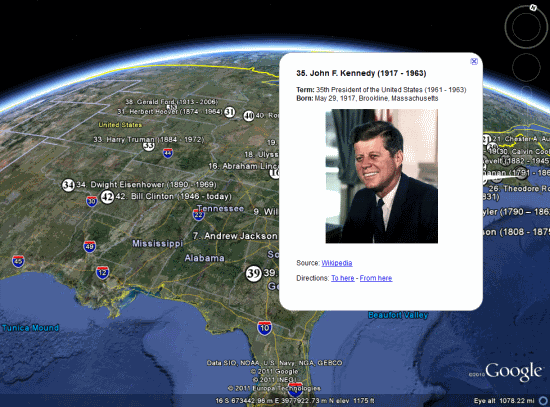
 page, which uses the Google Earth Plug-in and various tours to show you around. If you’d rather just explore the information on your own, as seen above, you can use