Business Photos Pilot: your business with a 360-degree perspective

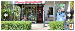
When you are looking for a restaurant in San Francisco, you can browse photos to see if the ambiance is right for the occasion. With our Business Photos pilot, we’ve been photographing businesses, with their permission, to highlight the qualities that make their locations stand out. In addition to the photos that business owners can upload directly through Google Places, these photos help potential customers get a better view of the decor, merchandise, food, and more on each business’ Place page.

Gruhn Guitars Inc. in Nashville, Tennessee, United States

We’ve also been taking 360-degree photography to help businesses owners showcase their locations further, and starting today you can experience that panoramic perspective for select businesses in the United States, Japan, Australia, and New Zealand.

This experience, using Street View technology, includes 360-degree imagery of the business interior and storefront. With this immersive imagery, potential customers can easily imagine themselves at the business and decide if they want to visit in person.

Tenkai, Kyoto, Japan

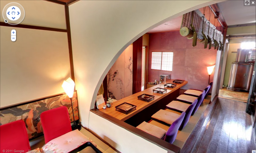
We’re now starting to make these images available through the Place pages of select businesses we’ve photographed. When 360-degree imagery of a business is available, you’ll see an arrow appear over the thumbnail Street View image on that business’ Place page. Press the arrow to preview the storefront or interior, then click on the thumbnail to see the image in Street View.

Storefront thumbnail for Susan Avery Flowers and Event Styling in Australia

With this pilot, you’ll begin to see additional photo experiences on the Place pages of a growing number of businesses. As additional imagery becomes available for more locations in the coming months, you’ll also be able to enter the interior perspective of businesses directly from the Street View images of nearby roads on Google Maps.

We’re continuing this program with businesses in select cities in the United States, Japan, Australia, New Zealand, UK, South Korea, and France. If you would like to highlight your business to Google Maps users, please visit the Business Photos site to learn more and apply.

Google Transit goes to Washington

Every day, many thousands of commuters, locals, and tourists ride public transit in Washington, D.C. To help all of these transit riders find their way around the metro area, today we’re making comprehensive information about D.C.’s public transportation available on Google Transit.

In partnership with the Washington Metropolitan Area Transit Authority (WMATA), we’re adding all of D.C.’s Metro and bus stations, stops and routes, as well as connections to other transit systems in nearby cities. You can find this information on Google Maps as well as Google Maps for mobile—no matter where you are, you can get to where you’re going. With Google Transit, D.C. metro-area commuters—including those in Baltimore, Montgomery and Jefferson counties—may discover a quicker route to work, while visitors can easily make their way from Reagan National Airport straight to the Smithsonian.

Public transportation is a vital part of city infrastructure and can help alleviate congestion and reduce emissions. But planning your trip on public transit can be challenging, especially when there are multiple transit agencies and you need to use information from multiple sources to figure out the best route. With mapping tools like the transit feature, we’re working to make that easier.

Directions are also available on Google Maps for mobile—so if you’re graduating from GWU and want to meet some friends in Adams Morgan to celebrate, it’s as easy as pulling out your phone. If you’re using an Android device, for example, search for [Adams Morgan] in Google Maps, click on the Places result and select “Directions.” Switch to Transit in the upper-left corner and find out which bus gets you there fastest.

Wherever your journey takes you, whether using public transit, driving, biking or walking, we hope Google Transit directions in D.C. make finding your way a little easier.

Sketchup:The Fat Pencil Studio

The company name “Fat Pencil” refers to the traditional drawing instrument used by architects during the early stages of conceptual design—when it’s important to get ideas on paper quickly, and avoid getting bogged down by details. Google SketchUp Pro provides a digital equivalent of this practice, and it’s been an essential tool for us since Fat Pencil Studio was founded in 2004.

Fat Pencil Studio creates technical graphics for legal, transportation, and construction professionals. Some examples are courtroom exhibits, infrastructure visualization and site logistics diagrams. Our staff have engineering and architecture backgrounds. We use this experience to develop compelling visual presentations for complex projects.

This trial exhibit is designed to allow witnesses to identify their vantage point in a birds-eye view, and then zoom to a street-level perspective using the Position Camera tool.
In this construction diagram, pre-assembled pipe sections are lowered into a utility tunnel.

Last year, we helped the City of Seattle visualize the reconfigured Broadway and Jackson Street intersection along the proposed alignment for the First Hill Streetcar extension. URS (the prime contractor for the project) had already developed 2D design drawings in AutoCAD. They needed 3D perspectives for public stakeholder meetings and regulatory filings. Once the model was created, Alta Planning (another member of the design team) was able to use it as a design tool. Each intersection could now be seen from multiple perspectives: driving, cycling, and walking. This allowed Alta to identify and address safety issues related to a two-way Cycle Track proposed for the reconfigured street.

Aerial view of the proposed Broadway and Pike Street Station.

The buildings in this area of Seattle are already in Google Earth’s 3D Buildings layer, so we initially considered importing street features into Google Earth to create a presentation. However, the difficulty of matching terrain over such a large area forced us to scrap this plan. SketchUp Pro offers more flexibility for presenting the details that matter most in this project; namely, the new street configuration. After cleaning up the AutoCAD drawings, we draped the linework over imported terrain and then added 3D features. We used several plugins to help reduce modeling time: Projections V2 helped with the curbs. Drop and RepeatCopy helped us place trees, cars, bikes and people. We also had some help from the 3D Warehouse, including an excellent streetcar model by JediCharles.

Street level view of the 2nd Avenue and King Street Station.

The streetcar project also gave us an opportunity to collaborate with another firm. IBI Group of Portland was responsible for station design and also modeling the southern half of the 2.5 mile streetcar alignment. Their half of the model was created in SketchUp on Windows, using terrain data from a street survey. Our half was modeled with SketchUp on a Mac, using terrain data from Google’s servers. The terrain matched almost perfectly at the seam, with only minor “smooving” needed. Using the combined model, we were able to generate dozens of still image views and several flyover animations.

Existing conditions at North Vancouver and Broadway in Portland, Oregon.
Turning on “Hidden Geometry” reveals the component segments used to build street markings.

Currently, we are working on a project to present options for safety improvements in a few sections of Portland’s extensive bikeway system. In this case we did not have detailed CAD drawings as a starting point; this gave us an opportunity to try a new approach for modeling street markings. Using high-resolution satellite images as a reference, we traced a single line along the center of existing markings. The PathCopy script allows us to “paint” the street markings as a series of components. Spacing can be configured for dashed lines, or set to zero for solid lines.