Changes in Google Place Page

Last week there were a number of new features that appeared in Places and in the 7 Pack including the inclusion of event information on venue Place pages and pushing the ppc hotel booking feature to the front page. There were several that I did not have time to report on that hit my radar:

Whether a bug or by design, the business email address has been removed from the Places page (thanks to reader Robert Ramirez of localrezults.com). He noted, and I agree, that it is a critical piece of information to have about your business on a page that Google positions as a comprehensive “search result” and its absence is strange.

Another interesting tidbit, particularly amidst the frequent disputes over reviews that have occurred, is that Google is now including links to the major review sites near the top of the listing. From a UI point of view it is redundant as the information is readily available down the page. One can only speculate that its inclusion above the fold was an effort to placate the likes of TripAdvisor and Yelp (and I am sure others).

New Google Earth for Android 2.1+

When was launched Google Earth in 2005, most of us were still using flip phones. At the time, the thought of being able to cart around 197 million square miles of Earth in your pocket was still a distant dream. Last year, that dream came to fruition for Android users when Google released Google Earth for Android. With the recent release of tablets based on Android 3.0, we wanted to take full advantage of the large screens and powerful processors that this exciting new breed of tablets had to offer.

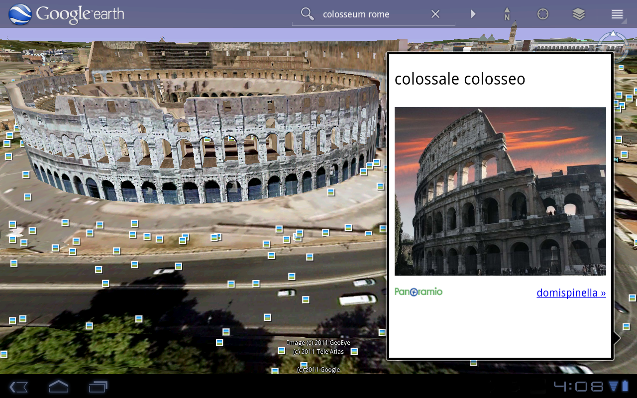
Today’s update to Google Earth for Android makes Earth look better than ever on your tablet. We’ve added support for fully textured 3D buildings, so your tour through the streets of Manhattan will look more realistic than ever. There’s also a new action bar up top, enabling easier access to search, the option to “fly to your location” and layers such as Places, Panoramio photos, Wikipedia and 3D buildings.

Moving from a mobile phone to a tablet was like going from a regular movie theatre to IMAX. We took advantage of the larger screen size, including features like content pop-ups appearing within Earth view, so you can see more information without switching back and forth between pages.

One of my favorite buildings to fly around in Google Earth has always been the Colosseum in Rome, Italy:

With the larger tablet screen, I can fly around the 3D Colosseum while also browsing user photos from Panoramio. The photos pop up within the imagery so I can interact with them without losing sight of the Colosseum and its surroundings. Also, by clicking on the layer button on the action bar, I can choose which layers I want to browse.

This version is available for devices with Android 2.1 and above. The new tablet design is available for devices with Android 3.0 (Honeycomb) and above. Please visit the Google Earth help center for more information.

To download or update Google Earth, head to m.google.com/earth in your device’s browser or visit Android Market. Enjoy a whole new world of Google Earth for tablets!

Google Maps and Earth – Post-tornado mapping

This past week, several devastating tornadoes struck across a wide swathe of the southern United States. Our Crisis Response team is activating to provide data and imagery we hope will be useful to first responders and the general public.

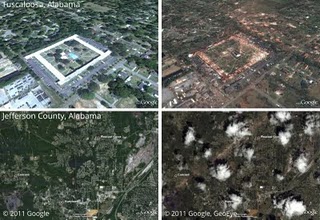
In cooperation with our satellite partner GeoEye, we have imagery of the aftermath of several tornadoes, including in Tuscaloosa, Alabama as shown below. We have created several before-and-after comparisons in a Picasa album.

Left: Google imagery from late 2010. Right: GeoEye imagery from Thursday, April 28.
Top: Charleston Square Apartments, Tuscaloosa, Alabama. Bottom: Towns of Pleasant Grove, Concord, and Hueytown, Jefferson County, Alabama. Click to see enlarged.

This imagery, as well as data sets such as Red Cross shelter locations and tornado touchdown reports, are available in this collection on Google Maps. We will continue to add imagery and data as it comes available.

Our heart goes out to everyone affected by this tragic event.

Update: You can now access the satellite imagery directly in Google Earth. Make sure the Places layer is enabled, then go to Alabama. Click the image of a tornado to find links to load the images.