Provides an overview of the new features of ArcGIS 10 by showing a workflow siting cell phone towers in Yosemite National Park.
Provides an overview of the new features of ArcGIS 10 by showing a workflow siting cell phone towers in Yosemite National Park.
Back in 1989, Australian climber Roderick Mackenzie become the 271st person to reach the summit of Mt. Everest. While up there, he captured a 360 degree panorama of the view from the top, which appears to be the only panorama ever captured up there.
Steven Ho stumbled upon that panorama recently and thought it would be great to compare the panorama to the always-improving terrain of Google Earth. With that in mind, he created an excellent page that uses the Google Earth Plug-in to change your view as you browse around the panorama. It works great!
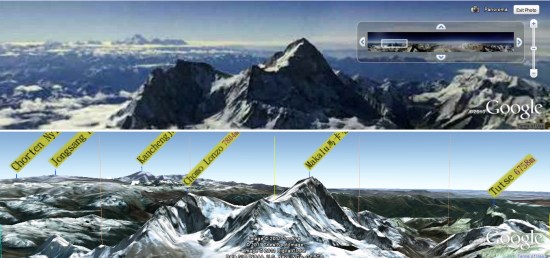
To learn more about what he’s done and to try it for yourself, visit Steven’s blog. Click the panorama image at the top of the text to enter the panorama/plug-in page. Once you’re inside of it, simply drag the top image around to view any particular area, and the bottom image will stay in sync automatically.