OziExplorer for Android is moving map software for devices running the ANDROID O/S. It uses raster map images which are either scanned or purchased in digital format. It allows you to track your position received from the GPS on a map (moving map).
OziExplorer for Android is not automatic route planning software, you cannot request the best way to get from point A to point B, the types of maps OziExplorer for Android uses do not allow this.
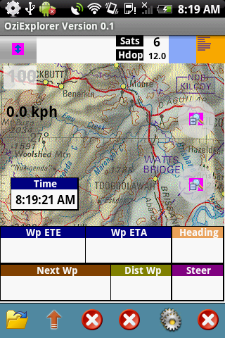
OziExplorer runs on Android devices but it relies on map calibrations etc to be provided by the full PC version of OziExplorer, you also need the full OziExplorer to calibrate maps, plan trips by adding waypoints etc.
The unlicensed OziExplorer for Android will work with the unlicensed OziExplorer but the limitations of both packages will apply.
Main Features
- Moving map navigation using the internal GPS.
- Course Up Mode.
- 3D Perspective View Mode.
- Uses almost any map which can be created by the PC version of OziExplorer.
- Use our Img2ozf utility to convert maps to OZFX3 format.
- OZF2, OZFX3, ECW, JP2 (jpeg 2000) directly supported.
- PNG, JPG directly supported (small maps less than 20MBytes uncompressed).
- Automatic loading of the next map.
- Check for more detailed map at a set interval.
- User tracks can be loaded
- Logging of Track points to file.
- Create Waypoints at current position by pressing the Create Wp screen button.
- Many Map Zoom levels.
- Various Position display formats.
- On screen display of Speed, Bearing and Altitude.
- Display Waypoints on the map.
- Satellite View showing SNR, number of Sats and HDOP.
- + many more features to be added in future versions.
Devices Supported:
OziExplorer Android will run on smartphones and tablets which run the Android O/S.
- Android 1.5 (tested and runs but may not be fully supported)
- Android 1.6 / 2.0 / 2.1 / 2.2 / 3+ supported.
- Portrait and Landscape is supported.
- All screen resolutions are supported.
Note – No useable maps are provided with OziExplorer for Android, only example maps.
The software is tested on the following devices:
HTC G1 – Android 1.5 (192MB ram) (320 x 480 screen) (may have memory limitations)
HTC Hero – Android 2.1 (288MB ram) (320 x 480 screen)
Superpad 2 / Flytouch 3 – Android 2.2 (512MB ram) (1024 x 600 screen)
Download OziExplorer Software for Android

