Google Earth: Le Tour de France

The 2011 Tour de France has recently gotten underway, and Cycling the Alps has built some fun tools to help you see the conditions that the riders are up against.

We’ve shown you some of their work in the past, such as the great games that they added to the site earlier this year. Now they’ve combined that technology with the Tour de France and the result is quite cool.

paris.jpg

They’ve gone through and created 3D tours, Streetview tours, profiles and games for every leg of the race. It’s quite an impressive list. Here are a few of the highlights to look for:

Stage 8

There are two stages in the Massif Central which are going to be very challenging, including the last two climbs in this stage: Col de la croix Saint Robert and Super-Besse Sancy.

Stage 12

In the Pyrenees and the climbs of this stage are epic. The Tourmalet is the most famous one but Luz-Ardiden gets a lot of attention in the media as well.

Stage 14

Stage 14 in the Pyrenees is probably the most difficult stage in the race, with six significant climbs.

Stage 18

This years tour is celebrating 100 years of high mountain stages, and every race featured a climb of the Col du Galibier. This year they’ll be climbing the pass two times; once from each side. In stage 18 they will even finish on the Galibier. This is the highest stage finish in the history of the Tour de France.

Stage 19

The next day they will climb the Col du Galibier from the other side, and all three climbs on the 19th stage are legendary.

There’s an amazing amount of info on this site about the Tour, and the games make it fun to ride around on each stage. Congrats to the CTA team for putting this all together.

Mapquest 4 – Free Turn by Turn on the iPhone

I very rarely drive to places unknown and thus am in little need of turn by turn navigation. Certainly not enough to buy a dedicated GPS device and not enough to warrant investing $99 in the iPhone TomTom app.

But it turned out that it was best for me to drive to Getlisted Local U in Grand Rapids this past week and since I was traveling solo I decided to use Mapquest 4′s iPhone app with turn by turn capability. I had 3 legs to the trip; Olean to a near in Detroit suburb, Detroit to Grand Rapids and Grand Rapids to Rondeau Provincial Park in Canada. With but one glitch, I can report that the performance of the product was superb… it reliably alerted me of upcoming turns, had very accurate maps and even went into a reduced volume mode when I was talking on the phone so that I could hear its instructions in the background

I can’t speak to its global use or even its value in far away places where road data is likely to be less accurate but as a general purpose tool it performed very well almost all of the time.

The one exception was when attempting to get onto the bridge to Canada in Detroit…. the entrance was under construction and between the GPS and the detour signs I was caught in an endless loop across the highway several times and not finding the entrance. When I finally saw a state road sign that read:

Follow the detour signs NOT your GPS (idiot was implied) I realized that Mapquest was not the only GPS experiencing the problem. The mass of cars of which I was but one, seemed to be guided by the same bad instructions, and all successfully made it onto the bridge and into Canada.

As smart phone penetration has reached such high levels and the quality of free turn by turn products hits “good enough” levels, the role of the low end dedicated GPS devices will continue to decline.

The market is reflecting this reality. TomTom bought TeleAtlas for $8 billion several years ago. The combined company is now worth a fraction of that and things don’t look rosy for them going forward. Certainly a $99 app isn’t going to save them.

With Google going their own way on map data in the US and Bing partnering so closely with Nokia, the opportunities for TomTom/TeleAtlas seemed to be dramatically diminished in the low end. Its not clear who would want to buy the combo either.

Google Earth: Mapping the Peachtree Road Race


The 42nd annual Peachtree Road Race, one of the largest 10K races in the world. There are expected to be 60,000 running the race this year, so it should be quite an event.


peachtree-crowd.jpg 

There are a variety of sites that have interactive maps of the course, and I’ve found MapMyRun.com is one of the best. Along with standard maps of the course, they also provide an elevation profile, which explains why many people run too fast during the first half of the race and burn out before the finish:

elevation.jpg 

Of course, my favorite feature is simply being able to download the KML file 
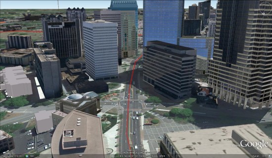
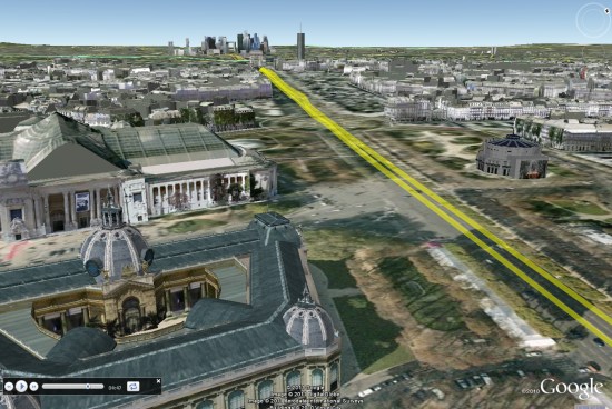
and explore the course for myself. Atlanta has solid 3D building coverage, especially toward the end of the course:

peachtree.jpg 

The race is held every year on July 4th, which is Independence Day in the United States. If you’ll be celebrating the holiday today, I hope you have a great time and stay safe!