Street View is digitalizing Japan’s disaster zones

After the March 11 earthquake and tsunami devastated the coastal communities of Eastern Japan, we at Google tried to find ways to use our technologies in support of relief activities. This started immediately after the quake with our Person Finder to help locate displaced individuals, and more recently we’ve started projects to spur economic recovery in the affected areas, such as the “YouTube Business Support Channel,” which enables local businesses to promote their products and establishments to a nationwide audience.

We also believe that the Street View feature in Google Maps can be a useful tool to offer street-level imagery of the recovery efforts. Many photographers felt the disaster couldn’t be captured in just one photo or with a single camera, but immersive, 360-degree panoramic images can help people — especially those abroad — better understand the scope of the destruction.


On July 8, we announced that we’ll be driving our Street View cars across major cities (such as Sendai) and coastal cities of the Tohoku region to not only help communicate the current state of the disaster-affected areas, but also to digitally archive the area’s landscapes for future generations. This imagery will help people in Japan and across the world remember and observe the tragedy of March 11, 2011.

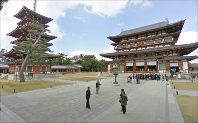
In addition to preserving history through Street View, the team in Japan has been busy publishing 360-degree imagery of more than 100 famous sites across Japan through our Street View Partner Program. The places that have partnered with us to share views of their locations on Google Maps include UNESCO world heritage sites Yakushi-ji temple, Toshodai-ji temple, and Kasuga-Taisha shrine in the ancient capital city of Nara. We’re also continuing the Business Photos project in Japan and are working with hundreds of businesses to photograph their interiors, get those images online, and show both local customers and visitors that they are open for business.

Yakushi-ji Temple in Nara, Japan
If you’re interested in directly supporting the ongoing relief effort in Japan, you can find more information regarding the disaster and resources for those in need at our Crisis Response page in English and Japanese.
Examples for Exporting Access table or query to EXCEL Workbook Files Part 2

Create a Query and Export multiple “filtered” versions of a Query (based on data in another table) to separate EXCEL files via TransferSpreadsheet (VBA)

Generic code to create a temporary query, get list of filtering values, and then loop through the list to filter various data and export each filtered query to separate EXCEL files. In this sample code, the employees assigned to each manager are exported to separate EXCEL files, one file for each manager.


Dim qdf As DAO.QueryDef
Dim dbs As DAO.Database
Dim rstMgr As DAO.Recordset
Dim strSQL As String, strTemp As String, strMgr As String

Const strQName As String = "zExportQuery"
Note:

Set dbs = CurrentDb

‘ Create temporary query that will be used for exporting data;
‘ we give it a dummy SQL statement initially (this name will
‘ be changed by the code to conform to each manager’s identification)
strTemp = dbs.TableDefs(0).Name
strSQL = “SELECT * FROM [” & strTemp & “] WHERE 1=0;”
Set qdf = dbs.CreateQueryDef(strQName, strSQL)
qdf.Close
strTemp = strQName

‘ *** code to set strSQL needs to be changed to conform to your
‘ *** database design — ManagerID and EmployeesTable need to
‘ *** be changed to your table and field names
‘ Get list of ManagerID values — note: replace my generic table and field names
‘ with the real names of the EmployeesTable table and the ManagerID field
strSQL = “SELECT DISTINCT ManagerID FROM EmployeesTable;”
Set rstMgr = dbs.OpenRecordset(strSQL, dbOpenDynaset, dbReadOnly)

‘ Now loop through list of ManagerID values and create a query for each ManagerID
‘ so that the data can be exported — the code assumes that the actual names
‘ of the managers are in a lookup table — again, replace generic names with
‘ real names of tables and fields
If rstMgr.EOF = False And rstMgr.BOF = False Then
rstMgr.MoveFirst
Do While rstMgr.EOF = False

‘ *** code to set strMgr needs to be changed to conform to your
‘ *** database design — ManagerNameField, ManagersTable, and
‘ *** ManagerID need to be changed to your table and field names
‘ *** be changed to your table and field names
strMgr = DLookup(“ManagerNameField”, “ManagersTable”, _
“ManagerID = ” & rstMgr!ManagerID.Value)

‘ *** code to set strSQL needs to be changed to conform to your
‘ *** database design — ManagerID and EmployeesTable need to
‘ *** be changed to your table and field names
strSQL = “SELECT * FROM EmployeesTable WHERE ” & _
“ManagerID = ” & rstMgr!ManagerID.Value & “;”
Set qdf = dbs.QueryDefs(strTemp)
qdf.Name = “q_” & strMgr
strTemp = qdf.Name
qdf.SQL = strSQL
qdf.Close
Set qdf = Nothing

‘ Replace C:\FolderName\ with actual path
DoCmd.TransferSpreadsheet acExport, acSpreadsheetTypeExcel9, _
strTemp, “C:\FolderName\” & strMgr & Format(Now(), _
“ddMMMyyyy_hhnn”) & “.xls”
rstMgr.MoveNext
Loop
End If

rstMgr.Close
Set rstMgr = Nothing

dbs.QueryDefs.Delete strTemp
dbs.Close
Set dbs = Nothing

Solving problems with Dates in SQL

It’s important to remember that regardless of where you are using Access, if doing SQL from code you need your dates to be in US format dates eg:


" WHERE DateField >= #" & Format$(startDate, "mm/dd/yyyy") & "#"

South Sudan is on the map!


A few weeks ago, South Sudan became the 193rd country on the planet, but that wasn’t reflected in Google Earth until now. Stefan at Ogle Earth made some interesting comments about it when the new country was introduced, including:

• Why wasn’t Google ready for it from day one?

• What will they do about the disputed border areas?

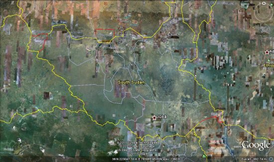
They delay may have been so Google could sort out the border issues. As Stefan suggested, Google has included a red border on parts of the country to indicate the disputed borders, as seen here:


south-sudan.jpg 

The red area on the center of the northern border of South Sudan is Abyei, which right now belongs to both Sudan and South Sudan. However, I’m not sure of the story on the red disputed area along the western border.

To see the new country for yourself, simply search for “South Sudan” in Google Earth and it will fly you directly there.