Mapping Hurricane

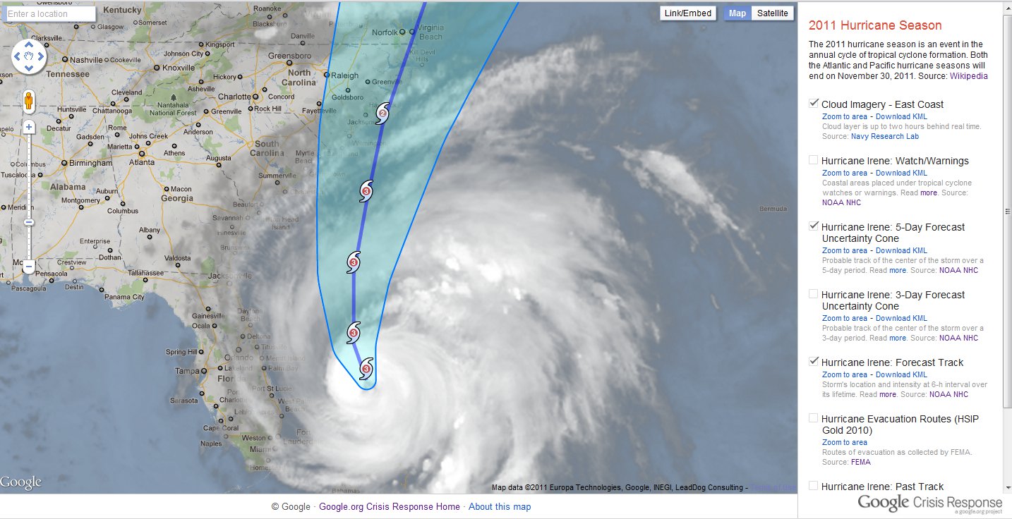
With Hurricane Irene headed towards the East Coast of the United States, the Google Crisis Response team has assembled a collection of map data to help you keep track of the storm. From this map, you’re able to get most recent hurricane-related information from such sources as NOAA’s National Hurricane Center and FEMA.

To help explore this information, we’ve created the Google Crisis Map, a map viewer with the latest available geographic information. Here’s some more information about the map’s content and features:

  • Google Crisis Map always shows the latest, valuable information we’ve been able to uncover on the most current situation
  • You can zoom and pan the map using the on-screen controls, and turn layers of information on or off just by clicking
  • You can find out more about the map layers by visiting the linked websites of the content owners
  • The site is optimized for mobile, so you can look at the map on a mobile phone as well as your desktop
  • You can also share the map, or embed it on your website or blog by clicking share to find the URL and HTML code

Hurricane Irene map viewer

To provide feedback or comments on the map, or if you’re aware of map layers or other datasets that you would like to see included on our maps, please submit them for our consideration at google.org/crisismap. We’ll continue to update the Crisis Response website with other valuable resources on Hurricane Irene and relevant preparedness tips.

To view the projected and historical path of Hurricane Irene in Google Earth you can visit the Google Earth Gallery or download the KML file.

Refugee Camp at Ethiopia

In the wake of intense drought, the Horn of Africa is gripped by its worst famine in more than 60 years. Over 12.4 million people across Kenya, Ethiopia, Djibouti and Somalia are threatened with hunger and disease as they are unable to access basic survival means. UN agencies and other humanitarian organizations are rallying to support refugees on the move, particularly to the thousands fleeing Somalia. Valerie Amos, OCHA Emergency Relief Coordinator, has stated that “This will not be a short crisis.” The emergency is expected to persist at least three to four months, and the number of people needing humanitarian assistance could increase by as much as 25 percent. Fresh and accurate maps are among the many critical factors in assessing such a state of crisis, as they provide vital information to facilitate emergency response and planning. Thanks to the efforts of our satellite imagery partner, GeoEye, we now have high resolution imagery of locations with the most pressing humanitarian needs. This has made Google Map Maker community mapping efforts even more effective, by allowing the creation of improved maps over refugee camps in Kenya, Ethiopia and the city of Mogadishu. Volunteers are mapping roads, hospitals, schools, community centers, and water resources, among other vital landmarks. The map data contributed is being shared periodically with the UN agencies engaged in this crisis. Google has also donated 1 million USD to help local and international organizations provide famine and drought relief support in the Horn of Africa.

Bokolmanyo Refugee Camp, Ethiopia. IKONOS imagery, July 29th 2011, © 2011 GeoEye

You can help the Horn of Africa during its time of crisis by creating detailed maps using your local knowledge of places, such as cities, roads, and natural landmarks. If you’re unfamiliar with the region, try pairing up with people who have local knowledge, who can help by reviewing and correcting your edits. To participate in these ways and more, and offer feedback, please join our Africa mailing list and visit the Horn of Africa community mapping site as we all map the way toward crisis relief.

More resources for Earthquake in Japan

Over the past week, we’ve worked hard to bring you the latest imagery and applications related to the Japanese earthquake and tsunami. Last week we showed you a list of various resources, then some fresh imagery that was released on Saturday, and then another update earlier this week with even more useful resources. Today we have a few new ones that you may find to be valuable.

The best use of imagery is probably ABC News and their impressive before and after maps. Just slide your mouse across a map to see the before/after shots compared, and you’ll be stunned by the differences.

abc-news.jpg

Next we have a useful map that is powered by the Google Earth Plug-in 
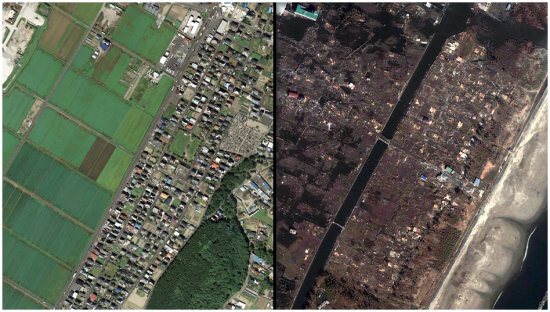
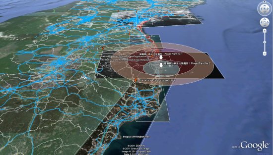
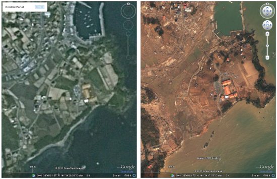
to show available roads in Japan, along with other information about flooded regions, power plant locations, etc. Data comes from HONDA, GeoEye and other sources.

traffic.jpg

Google Maps Mania points us to the Japan Quake Map, which shows a timeline of the earthquakes around the country. This is by Paul Nicholls, who also brought us the Christchurch Quake Map back in February after the major earthquake in New Zealand.

japan-quake-map.jpg

For a bit more imagery, NASA has released some fresh images of Ishinomaki, which you can view here or see in Google Earth using this KML file.

nasa.jpg

They also released a nice before/after view of Rikuzentakata, which you can view here.

GeoEye, in addition to releasing a ton of imagery as we’ve already seen, also released a stunning photo of Ishinomaki yesterday, which you can find here in their gallery.

ishinomaki.jpg

Last fall, we showed you the cool “AnotherEarth” site that allows you to view two Google Earth plug-in windows side-by-side to compare various features as you zoom around, and the windows stay in sync with each other. Now John has created a new version of the system that has the base (pre-earthquake) Japan imagery on one side, and the fresh imagery from various sources on the other side, giving you a great tool to see the before/after differences for much of the country.

another-earth.jpg

The digital resources regarding Japan are pouring in, so hopefully the financial resources are as well. Many ways to give are listed on the Google Crisis Response page and we encourage you to consider donating to the cause. You can also view this post on the Official Google Blog for additional resources.