The Thailand Floods


As Google often does during disasters (such as the Gulf Oil Spill and the Japan Earthquake, Google has set up a Crisis Response page to help provide information for those trying to assist with the flooding in Thailand.

The flooding has become quite devastating and more widespread than most people realize. From Google’s page:

Thailand is currently facing its worst flooding in 50 years. Flood waters have swamped more than two-thirds of the country, submerging rice fields and shutting down hundreds of factories while over 900,000 families and businesses have been impacted and hundreds of lives have been tragically lost. National relief efforts are now focused on providing essential food, clean water and shelter to displaced people and restoring damaged infrastructure to the Kingdom of Smiles.

You can use the map on their page, or download various elements as KML files to be able to browse them in Google Earth. For example, here is the “Flood affected areas across Thailand” map (KML), which gives you a quick glance at the hardest hit areas.
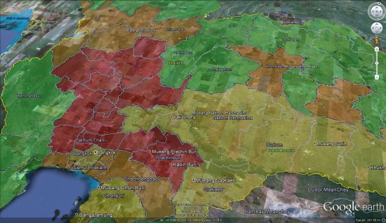
 

flood-affected.jpg 

For fresh satellite imagery of the area, you can use the imagery released by the NASA Earth Observatory a few days ago. You can view the image on their site.
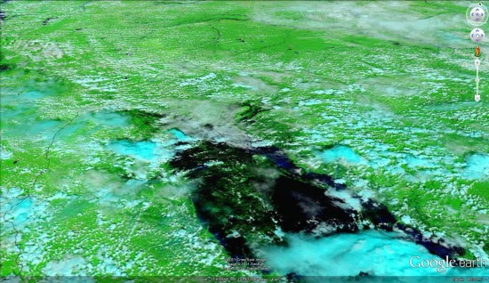
 

thailandimagery.jpg 

Google Maps Mania

The Philippines hosts a Maps for preparation of natural disasters

This summer, a group of Filipino mapping enthusiasts organized an impressive series of Google MapUps throughout the Philippines. The events brought together Google Map Maker mappers across the country to map their communities in preparation of natural disasters. Located in the western Pacific typhoon belt, the Philippines is struck by an average of 20 tropical cyclones every year. As demonstrated by the 2009 Typhoon Ondoy (Ketsana) and Pepeng (Parma), which left much of Metro Manila underwater, the storms are both persistent and devastating.

The extensive series of Summer MapUps was organized by mappers from Luzon, Visayas and Mindanao after meeting at the Google Geo User Summit in Singapore. Following in the footsteps of super mapper Rally de Leon, who mapped extensively after the 2009 typhoons, this summer of MapUps was designed as a volunteer project for the Philippine Red Cross. The objective was to map places used during crisis, including health centers, government offices, gymnasiums and public schools used for evacuation.

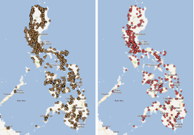
All of the schools (left) and hospitals (right) in the Philippines, as mapped on Google Map Maker.
The events kicked off in the Mindanao region, with MapUps in Malaybalay, Bukidnon and General Santos City. Northern Luzon followed with a MapUp in the City of Pines, Baguio City. Baguio City was hit by a devastating earthquake a decade ago, which took the lives of over a thousand people. Volunteers wanted to make sure that they tagged important places, such as evacuation relocation sites, that would help in rescue and relief.

MapUps in Iloilo City, Metro Manila, Zamboanga and Cebu City followed. Zamboanga mappers focused on Zamboanga Peninsula, one of the least mapped areas in the Philippines. The Cebu City volunteer mappers were geology students from University of the Philippines Visayas Cebu College. They enjoyed tagging, moderating and editing data, and vowed to continue mapping to complete the Cebu map.


Even though summer is over in the Philippines, we will still continue to add map data using Google Map Maker as an effort to help the Philippine Red Cross. If you are interested in hosting a MapUp in your neighborhood, or have other great mapping ideas, be sure to visit Map Makerpedia, which brings together lessons, tutorials and use cases from around the world.

The earthquake tsunami changed the Ice


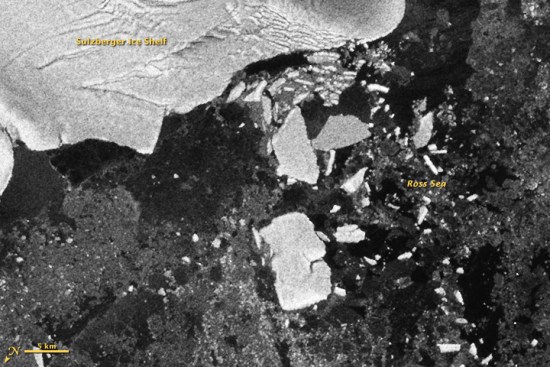
When the earthquake (and subsequent tsunami) struck Japan earlier this year, we provided as much data as possible about the disaster. What many people didn’t realize was that the tsunami continued to travel across the ocean, eventually striking Antarctica with a great deal of force. This caused some flexing and breaking of the Sulzberger Ice Shelf, which resulted in two large icebergs being released, reminicient of the chunk of the Wilkins Ice Shelf that broke off a few years ago. Combined, the icebergs cover an area of 125 square kilometers, or more than twice the size of New York’s Manhattan Island!


sulzberger_sar_2011075.jpg 


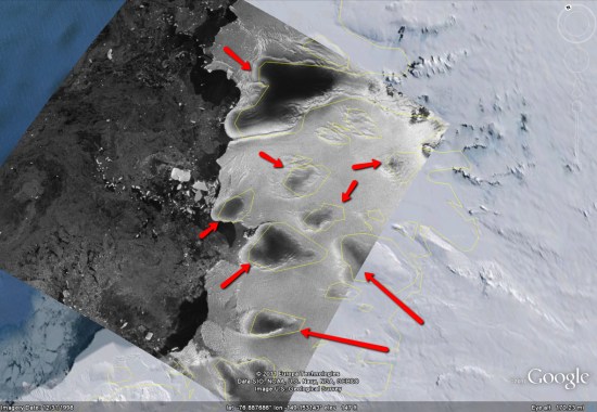
You can download the KMZ file here.

If you turn on the “Borders and Labels” layer in Google Earth, you’ll see the yellow outlines match up quite well with the dark patches in the overlay, as seen here:


overlay.jpg