OpenStreetMap Skiing

A few weeks ago we showed you a handful of neat tools to help you enjoy the ski season a bit more, but we missed a big one — Skimap.org.

ski-trails.jpg

The main idea behind SkiMap is to allow users to upload maps from various ski resorts and share them with other users. Recently, however, they added a feature that uses the OpenStreetMap API to convert OSM data into KML vector ski maps. In just the past month, 940 ski maps were generated for use on the site!

The quality of the maps varies by location — European resorts are more fully mapped than US ones, and in the US they’re in better shape on the eastern half of the country. However, with the rate at which new ones are being added, your favorite ski area will probably look good on there very soon.

To see a good example of a ski area, check out Whistler Blackcomb. They have 67 different printed maps for Whistler, along with a handful of “OpenSkiMaps”. Here’s a KML file from one of them if you want to see it in Google Earth.

Broadband Speed Mapped for BBC Look East Research

BBC Look East is calling for people in the East of England to find out their home broadband speed, as part of the TV programme’s week-long special – using our free SurveyMapper tool, at CASA, University College London, to collate and map the results in real time. So far over 6500 responses have been received.
It is estimated only 60% of households in the region have access to high speed broadband.
Look East’s business reporter Richard Bond said that the figure was unlikely to grow much in the next five years.
Home broadband users can take part by plotting their speed onto an interactive map.
The results of the research will then be shown on BBC One during Look East’s broadband week, which runs from 21 to 25 February 2011.
“Fibre optic networks, the key to a fast service, are only available to people in and around the major towns and cities,” said Mr Bond.
“Broadband speeds in rural areas are slow because they depend on copper telephone exchanges.
“Although BT is rolling out its fibre optic network, this is unlikely to make much of a difference to most rural communities over the next five years,” he added.

Speed test

Broadband users can test their upload speed on BBC News’ Technology website.
As broadband speeds on the same connection can fluctuate, it is recommended that people take the test several times and make a note of the highest speed.
Other speed-testing websites could return different results, so it is recommended for this research that third-party sites are avoided.
Once a figure is obtained, people can then plot their results on the BBC Look East map hosted on our SurveyMapper.
It is nice to see maps and indeed crowd sourced surveys used in such a way, SurveyMapper has been developed as part of NeISS (National e-Infrastructure for Social Simulation, funded by JISC as part of its Information Environment Programme.
You can set up your own survey or poll on SurveyMapper – If you have used other ‘polling sites’ then you will be up to speed, except we have taken away the restrictions and added real-time mapping into the mix. Simply sign up (its free) and then your be able to create your own survey and embed it into your own site. Currently we have five levels of survey available – Worldwide, based on countries, European Countries US Zip Code, UK Postcode and a Drag and Drop Pin Map.


You can ask anything, survey the nation, the world or just your street with real-time mapping and statistics.


To take part or create your own survey head over to SurveyMapper.com

The Look East survey runs until February 25th with updates each evening on BBC Look East News.

Street View takes you inside museums around the world

We’re always excited to share new Street View imagery with users, whether a botanical garden in South Africa or ski slopes in Canada. While Street View has enabled users to visit places all around the world virtually, the demand to show a broader range of popular locations has been great. Today we’re entering new territory with our experiment to take Street View technology indoors.
The Art Project, developed by a group of art-loving Googlers, is a collaboration between Google and 17 of the world’s most acclaimed museums. Select works of art chosen by these partners are now available for you to explore through Street View in Google Maps, and the Art Project site offers an immersive experience to explore museum information, floor plans, more than 1000 high-resolution pieces, and Street View imagery. Learn more about the Art Project on the Official Google Blog.
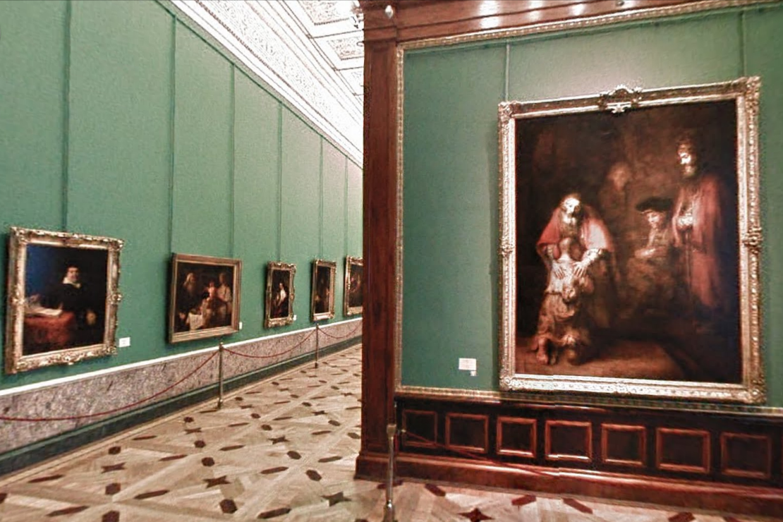
To take you inside magnificent spaces like the State Hermitage Museum in St. Petersburg, Russia, our team needed to update the way we go about gathering Street View images.
The State Hermitage Museum, St. Petersburg, Russia
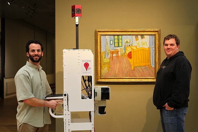
Street View imagery is typically collected using cars and we’re able to utilize the ample roof space and interior storage of these vehicles for all of our equipment. To take Street View technology indoors, we needed to fit all of the equipment on a much smaller vehicle, a push-cart lovingly dubbed Trolley.
Pictured with Trolley: Daniel Ratner, Mechanical Engineer and Matt Williams, Program Manager at the Van Gogh Museum in Amsterdam, The Netherlands
Trolley is outfitted with a few components that are key to collecting indoor imagery: a panoramic camera to collect 360-degree views, lasers to capture distances to walls, motion sensors to track Trolley’s position, a hard drive to store data, and a laptop to operate the system.
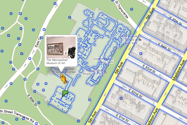
With this adapted equipment, we were able to gather the imagery and bring it into Google Maps, and you can now drag Pegman directly onto museums like the Metropolitan Museum of Art in New York City to explore their impressive European Paintings wing.
The Metropolitan Museum of Art, New York, United States
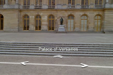
You can also enter museums when you’re already looking at Street View imagery of the museum exterior. You’ll notice new double-arrow navigation links from the nearby streets leading you inside, as you can see here for the Palace of Versailles.
Palace of Versailles, Versailles, France
Once inside the museum, you can navigate around rooms freely with the navigation arrows or simply click on a distant spot to jump to a closer view. Movement between floors can also be done with ease by selecting a different level from the new control panel below the Street View compass and zoom controls.
Alte Nationalgalerie, Berlin, Germany
We’re excited to introduce this new imagery in Street View, and will continue to improve and develop this indoor experience. To explore these museums directly through Street View in Google Maps, visit maps.google.com/museums, and to view high-resolution artwork and learn more about the museums, check out the Art Project at www.googleartproject.com.