Google Earth: The Harrisburg Capitol Complex


As I’ve mentioned on here on GEB a few times, I love high-quality 3D models. I think they add a lot to the Google Earth experience, and I enjoy highlighting users that create awesome models.

In the past we’ve shown you work from people like Andy Dell and companies such as Estate3D and CyberCity3D. Today I want to show you some of the work from Steve Cline of Urban 3D Modeling.


building.jpg 

He lives in Harrisburg, PA and built out much of the downtown area in 3D. In his words:

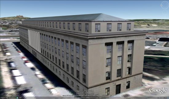
“As a resident of Harrisburg I wanted to show off the beautiful architecture and history of our state capitol complex. All the state government buildings are clustered into a dense complex that is bisected by State Street. The principle entrance from the east is the State Street Bridge which passes through two towering pylons as you enter directly into the Capitol Building and surrounding complex. Most of the complex buildings are a mix of neoclassical design and some art deco influence from the later additions. Of the 15 buildings in this collection my personal favorites are the Keystone Building, Judicial Center, and Forum Building. The only building not done by me was the previously done Capitol Building.”

You can find all of the models in Google earth, and he’s also put them together in a collection in the 3D Warehouse. For a quick look at all he’s done, you can use this KMZ tour to fly around and see it all.

For more on Urban 3D Modeling, you can check out their website, follow them on Twitter or connect with them on Facebook.

SketchUp: The New England Aquarium

April Phelps is a LEED-accredited designer who works at the New England Aquarium creating new exhibits and enhancing existing ones. Boston’s New England Aquarium is one of the many non-profit organizations to which we’ve granted SketchUp Pro licenses as part of the SketchUp for Nonprofits program.

SketchUp Pro has been a big help to us in the New England Aquarium Design Department. The Aquarium was founded in 1969 and attracts over 1.3 million visitors a year to our waterfront location. Recently the Aquarium’s capital improvement plan called for a complete renovation of our changing exhibits space, and we decided to part with the Aquarium’s traditional design aesthetic and embark on a new path.

Families touching the rays in our new shark and ray touch tank exhibit


The newly completed exhibit we designed in SketchUp Pro is called The Trust Family Foundation Shark and Ray Touch Tank. It features sharks and rays in a mangrove-themed tank surrounded by shallow edges and viewing windows, allowing visitors to experience a close encounter with these animals.

The exhibit presents these incredible species in a way that highlights their importance in a healthy ocean ecosystem. It also emphasizes the value of conserving essential coastal habitats, such as mangroves and lagoons. During evening hours the new space is also used as an event venue for private functions.

View from the entrance of the shark and ray touch tank. On top is our design phase
rendering; below is an opening day photograph.


The Aquarium provides unique challenges for designers. We have a variety of internal clients with different needs, and we need a modeling program that works quickly and accurately to convey our ideas. SketchUp’s quick modeling capabilities provided me the extra time needed to explore multiple design options on this project.

SketchUp also enabled our design team to give everyone at the Aquarium a sense of the new exhibit’s aesthetics quickly and easily. In addition to quickly creating renderings, we imported actual material samples into our models. This allowed staff and visitors to get a sense of scale and of how significant the interaction with animals would be.

View from inside the exhibit towards the Lagoon and Cassiopeia tanks. Above is
our design phase rendering; below is an opening day photograph.


Our traditional design aesthetic for the Main Building is to make the visitor feel like they are submerged underwater, looking through portals to all the fish. The new exhibit needed to be airy and bright, allowing visitors to feel that they are no longer submerged but at the beach level interacting with the animals. To achieve this we revealed the once covered up skylights and installed a significant amount of energy efficient lighting. With natural and artificial lighting we simulated the feeling of wading around a beach touching sharks and rays.

View of The Trust Family Foundation Shark and Ray Touch Tank Gift Shop. The top image is our design phase rendering; below it is an opening day photograph.


This “no surprises” methodology allowed us to receive design input from different departments quickly. Given our very tight schedule and lack of resources, it proved to be most helpful. We’re excited to continue to use SketchUp Pro on future projects and renovations at the New England Aquarium.

Google Earth: Imagery Update Week of July 18th

The Commissioners’ Plan of 1811 proposed a highly regular grid pattern as the layout for an island that was mostly farmland and wilderness in a still-young country. Two hundred years after the streets and avenues were dreamed up, the landscape of New York City has changed dramatically as skyscrapers have been built, parks have been planted and the population has increased by millions. Today’s latest batch of updated imagery reveals new, high resolution imagery of Manhattan. It’s now live in Google Earth and will appear in Google Maps soon.

Times Square has become much more pedestrian-friendly.

Construction at the World Trade Center site is making clear progress.
Google NYC is located in the Chelsea neighborhood of Manhattan. I’m one of more than 2,000 Googlers here (split between Sales, Engineering, and other functions), making us the second-largest Google location. (Care to join us?) The sales team sits in Chelsea Market, a former Nabisco factory where Oreos were invented and which envelops the elevated High Line, which was recently converted into a park.

This new batch of imagery also covers another Google hometown: Boulder, Colorado, home to the 3D team that brings you Google SketchUp and the Google 3D Warehouse. That team expanded two months ago across the street. 

Want to check out how these places used to look? Use the Historical Imagery feature of Google Earth to slide back the clock around the world. And as always, we encourage you to check out more of the areas that can be seen in our latest imagery update. Enjoy!

High resolution aerial updates:

Boise, ID; Denver, CO; Topeka, KS; St Cloud, MN; Ashland, WI; Ironwood, MI; Flint, MI; Ft Wayne, IN; Cape Girardeau, MO; Bowling Green, KY; Glasgow, KY; Greenville, NC; Atlantic City, NJ; Syracuse, NY; Manhattan, NY

Countries/regions receiving high resolution satellite updates:

Canada, United States, Mexico, Cuba, The Bahamas, The Dominican Republic, Belize, Guatemala, El Salvador, Honduras, Nicaragua, Costa Rica, Panama, Colombia, Venezuela, Ecuador, Brazil, Peru, Paraguay, Bolivia, Argentina, Chile, Madagascar, South Africa, Lesotho, Swaziland, Namibia, Botswana, Mozambique, Zambia, Angola, Tanzania, Democratic Republic of the Congo, Uganda, Kenya, Somalia, Ethiopia, Sudan, Eritrea, Egypt, Niger, Burkina Faso, Ghana, Sierra Leone, Mali, Senegal, The Gambia, Mauritania, Morocco, Algeria, Yemen, Saudi Arabia, United Arab Emirates, Qatar, Kuwait, Jordan, Israel, Syria, Lebanon, Iran, Turkey, Russia, Finland, Sweden, Norway, Estonia, Latvia, Belarus, Ukraine, Poland, Hungary, Romania, Bulgaria, Greece, Albania, Serbia, Croatia, Austria, Germany, Italy, Switzerland, France, Spain, Portugal, England, Azerbaijan, Kazakhstan, Uzbekistan, Kyrgyzstan, Pakistan, India, Sri Lanka, Bangladesh, Nepal, China, Myanmar, Laos, Thailand, Vietnam, Cambodia, Malaysia, Taiwan, The Philippines, Japan, Korea, Indonesia, Australia, New Zealand

These updates are now available in Google Earth and coming soon to Google Maps. To get a complete picture of where we updated imagery, download this KML for viewing in Google Earth.