Rediscover Historical Imagery in Google Earth 6

Historical imagery is one of the most powerful features of Google Earth, enabling you to go back in time and browse the visual historical record of our planet – from the evolution and rise of developing communities to the destruction caused by hurricanes, earthquakes and fires. With Google Earth 6, we’ve made it easier than ever to discover historical imagery. In addition to streamlining the timeline interface, we’ve added a date button to the status bar to notify you of past imagery that you might be interested in exploring. So now, when you zoom in on a location in our latest version of Google Earth, the button will appear highlighting specific years. Clicking it enables historical imagery and takes you back to the year you selected. For instance, when I zoom in on the headquarters of a certain company with a fruit namesake nestled in the heart of Silicon Valley, Google Earth suggests imagery from 1948. Clicking the date button reveals the fruit tree orchards that used to inhabit that very location. I wonder if they were apple trees.
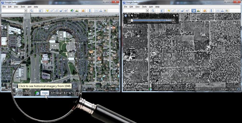
Google Earth 6 suggests historical imagery to explore, e.g. of Silicon Valley in 1948
In the almost two years that historical imagery has been available, we have captured several moments of cultural significance, such as the inauguration of the first African American President of the United States, the devastation of Hurricane Katrina, and the transformation of South Africa in preparation for the 2010 FIFA World Cup.
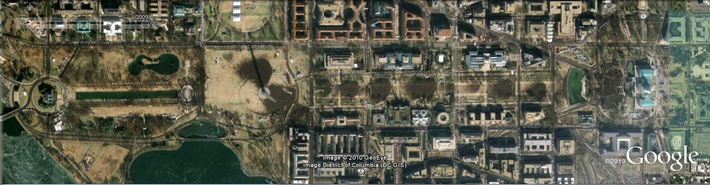
Washington D.C., January 20, 2009. Can you spot where the jumbotrons were installed?
But the feature is more than just what historians deem significant. We built the historical imagery database to enable anyone to see and tell their own personal history. A great example comes from fellow historical imagery engineer Reuel Nash:

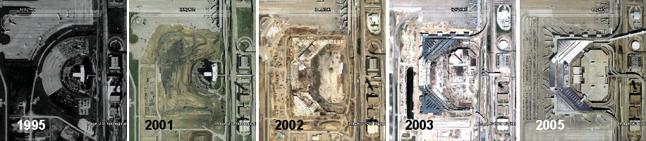
The construction of Terminal D at Dallas/Fort Worth International Airport
We have a vast amount of data in our historical imagery archive, so you’ll be able to tell your own personal stories by browsing those places that are special to you. In fact, we have more square miles of high resolution imagery in our historical imagery archive than in our default view. In the coming years, we look forward to expanding this imagery collection even further. Visit the Historical Imagery Showcase to watch video tours of cities with imagery dating as far back as 1940.
Posted by Chris Co, Google Earth Software Engineer

In 1979, my wife and I spent the first night of our marriage in a hotel at Dallas/Fort Worth International Airport. It was still there in 1995, which you can see in Google Earth. The hotel and the surrounding area has since been replaced by Terminal D. You can see the terminal construction (and destruction of the hotel) literally from the ground up using historical imagery.

New panoramic photos in Google Earth


Viewing photos in Google Earth has long been a popular activity for avid virtual globe-trotters. It’s one of the best ways to “visit” places all over the world without paying for a plane ticket or getting jet lag. Today, the Google Earth photo viewing experience just got better with the addition of panoramic images.

People using Google Earth will find a new “Photos” layer that includes not only the existing 2D photos from the Panoramio community, but also panoramic photos from around the world contributed by users of 360cities.net. These high-resolution panoramic photos are marked in Google Earth as red square icons. When you click on one of these icons, an info bubble containing an image appears, and clicking on the image again will take you into our photo viewing mode. You can then look around in 360-degree views and experience the place as if you’re standing right at the center of it.

new “Photos” layer on Google Earth
info bubble on Google Earth

These panoramic photos are shot by average people just like you and me. To contribute your panoramic photos, visit 360cities.net. We invite all users to become part of the community and mark your photo journey in Google Earth.

Check out some of the beautiful images now available right in Google Earth.

Golden Gate Bridge on Google Earth and on 360cities.net
Gapang Beach, Pulau Weh, Indonesia on Google Earth and on 360cities.net

Lion’s Head, South Africa on Google Earth and on 360cities.net

Diving New Caledonia Amedee Island on Google Earth and on 360cities.net

Umag Asanas, Istria at sunset on Google Earth and on 360cities.net

Panthéon and Foucault pendulum, Paris on Google Earth and on 360cities.net

Posted by Wei Luo, Senior Geo Data Strategist

Changing World, Changing Maps

Today, we are excited to let you know that we have updated the base map data in all Google Maps products and services for ten countries: Australia, Austria, Belgium, Denmark, Liechtenstein, Netherlands, New Zealand, Norway, South Africa and Switzerland. This follows earlier improvements to our maps in the US and Canada, and will be rolling out over the course of the next day.

Somewhere near you, a new road is being constructed, an existing one is changing names, a new restaurant is opening, or a parking lot is making way for a park. With this update, you can help keep your neighborhood accurate across Google’s geo product suite. Notice that something has changed on your block recently, or that the directions provided could have been better? Report a problem, and we will make the change in Google Maps within a couple of months.

We have worked hard to improve the usefulness of the maps for our users, developers, and business partners. Improvements range from including more address data and building footprints so you find your destinations easily, to adding higher resolution topographic features and detailed university campuses to help you orient yourself faster in a new area. We have also augmented our maps with bike paths and walking trails, and will roll out biking directions soon. We hope our maps help you explore your world better.

Posted by Anup Mantri, Software Engineer