Google Wallet: Working with Visa, American Express

In May we announced Google Wallet—an app that makes your phone your wallet—with Citi, MasterCard, Sprint and First Data. With Google Wallet, you can tap, pay and save using your phone and near field communication (NFC).

We’ve been testing it extensively, and today we’re releasing the first version of the app to Sprint. That means we’re beginning to roll out Google Wallet to all Sprint Nexus S 4G phones through an over-the-air update—just look for the “Wallet” app. Here’s a demo of Google Wallet in action:

Google Wallet enables you to pay with your Citi MasterCard credit card and the Google Prepaid Card, which can be funded with any of your existing plastic credit cards. As a thanks to early adopters, we’re adding a $10 free bonus to the Google Prepaid Card if you set it up in Google Wallet before the end of the year.

When we announced Google Wallet, we pledged a commitment to an open commerce ecosystem. We appreciate Citi and MasterCard for being our launch partners. And today, Visa, Discover and American Express have made available their NFC specifications that could enable their cards to be added to future versions of Google Wallet.

Our goal is to make it possible for you to add all of your payment cards to Google Wallet, so you can say goodbye to even the biggest traditional wallets. In fact, we’ve got a video of our first customer, someone who is ready to replace his famously over-stuffed wallet. We hope Google Wallet gives him “serenity now.”

This is still just the beginning and while we’re excited about this first step, we look forward to bringing Google Wallet to more phones in the future. You can learn more about Google Wallet at google.com/wallet.
The Pictarine: Building a mashup in the cloud with Google App Engine


Pictarine is a photo management web application, launched in 2010, that allows people to easily manage and share all of their photos from Flickr, Picasa, Facebook, Twitter and other sites. Pictarine developers Guillaume Martin and Maxime Rafalimanana have contributed the following post discussing their experiences using Google App Engine and Google Web Toolkit.

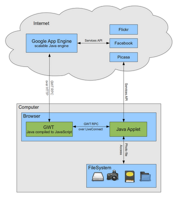
From the start, we used Google technologies in developing Pictarine and we wanted to share our experience with them so far. In this post, we will shed some light on the weaknesses and strengths we found in Google Web Toolkit (GWT) and Google App Engine. We will also discuss how we leveraged GWT to build a new technology that allows Pictarine to seamlessly display photos from the computer directly into the browser. The following diagram is an overview of how our application works.

Building a mashup in the cloud with Google App Engine

The Pictarine team is made of a web designer and two developers who previously worked mainly with Java based enterprise technologies and had a little experience with web technologies. When we started the project in early 2009, we were quite open on learning new languages like Python or Ruby, but when App Engine announced that Java would be supported, we were really excited to give Google App Engine a try.

The first few months, learning about the App Engine environment was quite easy and dare I say fun. Testing our code on Google’s servers from Eclipse IDE was only one click away. So we built our first prototype fast and we quickly decided to adopt App Engine. Then we started to build the core of our application: the engine that uses the API from Flickr, Picasa, Facebook to fetch the users’ photos. This is where we hit the first limitations of App Engine. Most users have a lot of photos on these services and retrieving them can take some time. But App Engine has strict limits on how long a request should last: an outgoing HTTP request cannot last more than 10 seconds and cannot process a request for more than 30 seconds. So while building our architecture we found ourselves writing approximately one third of our code dealing with these limitations: paginating our requests, creating background tasks to store data in small batches, etc.

In early 2010, when we launched our alpha version, everything went smoothly. We had some good press coverage and App Engine met our expectations in handling our first users. During 2010, we worked on implementing new features requested by our users, and during this period of time we were really impressed by the way App Engine evolved. Many of the limitations were lifted and great new features were added. We are now able to use Task Queues for requests that last up to 10 minutes, which we fully use to sync our users’ photos and albums. One of the features we like the most is the Channel API, a push notification system that allows us to instantly show a photo in every connected browser as soon as it is uploaded.
App Engine is still not perfect but has greatly improved and when we see its roadmap, we are quite confident it will continue to improve.

The Philippines hosts a Maps for preparation of natural disasters

This summer, a group of Filipino mapping enthusiasts organized an impressive series of Google MapUps throughout the Philippines. The events brought together Google Map Maker mappers across the country to map their communities in preparation of natural disasters. Located in the western Pacific typhoon belt, the Philippines is struck by an average of 20 tropical cyclones every year. As demonstrated by the 2009 Typhoon Ondoy (Ketsana) and Pepeng (Parma), which left much of Metro Manila underwater, the storms are both persistent and devastating.

The extensive series of Summer MapUps was organized by mappers from Luzon, Visayas and Mindanao after meeting at the Google Geo User Summit in Singapore. Following in the footsteps of super mapper Rally de Leon, who mapped extensively after the 2009 typhoons, this summer of MapUps was designed as a volunteer project for the Philippine Red Cross. The objective was to map places used during crisis, including health centers, government offices, gymnasiums and public schools used for evacuation.

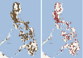
All of the schools (left) and hospitals (right) in the Philippines, as mapped on Google Map Maker.
The events kicked off in the Mindanao region, with MapUps in Malaybalay, Bukidnon and General Santos City. Northern Luzon followed with a MapUp in the City of Pines, Baguio City. Baguio City was hit by a devastating earthquake a decade ago, which took the lives of over a thousand people. Volunteers wanted to make sure that they tagged important places, such as evacuation relocation sites, that would help in rescue and relief.

MapUps in Iloilo City, Metro Manila, Zamboanga and Cebu City followed. Zamboanga mappers focused on Zamboanga Peninsula, one of the least mapped areas in the Philippines. The Cebu City volunteer mappers were geology students from University of the Philippines Visayas Cebu College. They enjoyed tagging, moderating and editing data, and vowed to continue mapping to complete the Cebu map.


Even though summer is over in the Philippines, we will still continue to add map data using Google Map Maker as an effort to help the Philippine Red Cross. If you are interested in hosting a MapUp in your neighborhood, or have other great mapping ideas, be sure to visit Map Makerpedia, which brings together lessons, tutorials and use cases from around the world.