RepRap Build This Weekend at CASA: Live Stream and Updates

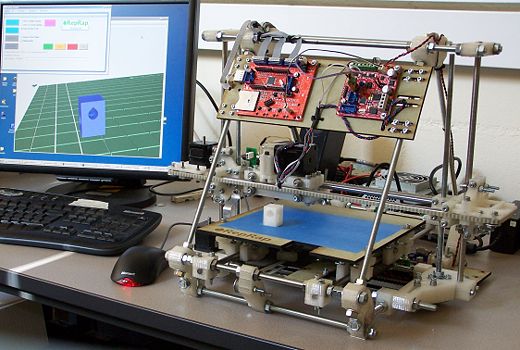
This weekend the office is being taken over by the RepRap 3D printer build. The PayItForward team are in – a group of altruistic people who have RepRap machines, printing parts and gifting them to people who want to make a RepRap machine with the requirement that once the 3D printer is running, they print off a set and pass them on in the same fashion.


The team will be documenting, tweeting (under #uclpifp) and hopefully, ustreaming the build as they go, (we will update this post with the stream when it goes live Saturday morning).

Follow Steven (@frogo), Graham (@gklyne), Ben (@benosteen) and Dave (@dfflanders) for more information as it happens.


We will be in and out as well with updates Andy@digitalurban, CASA is moving to our new open plan offices next week so its a weekend of packing and updating on the 3D printer build.

Dreamweaver for Google Earth

I noticed that Declan wrote up an idea we kicked around in September (see ‘September’ on the DigitalPlanet pages), so I thought it deserved a post. I referred to it then as ‘Dreamweaver for KML.
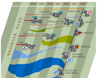
Image courtesy of favbrowser. A bit out of date but still interesting.

Browser History: In 1997 Netscape adds a feature to its Netscape communicator browser that allowed for WYSIWYG simple production of html web pages. To put that in context you have to recall that this was the late days of the browser wars between Microsoft and Netscape. Then in March 1998 Macromedia release dreamweaver 1, this allowed web pages to be created in WYSIWYG or code views and produced short cuts that produced elegant html. It was also extensible so you could write a ‘macro’ to produce custom HTML. Developers loved it.

Geo-Browser History: My point is that if you regard GEarth as a geo-browser then the history is similar. Today in GEarth you can create simple maps and tours just like in Netscape communicator you could create simple web pages. However, a lot of sophisticated features such as time, region control, pauses in tours need to be hand coded into the KML. There are a few tools out there that allow you to produce KML without hand coding such as the spreadsheet mapper, my spreadsheet for adding loops and a tool for adding screen overlays but these are all limited in scope.
Tool Description: An obvious improvement would be ‘Dreamweaver for Google Earth’, where all this functionality was combined into one specialist KML producing program just as dreamweaver was a specialist HTML producing program. It would need to be:
  • WYSIWYG, ie be able to write code directly or using wizards and then see the result in an instance of the GE API
  • Extensible allowing you to write an extension that produced your favourite snippet of KML structure.
  • Elegant, highly usable and producing well formed KML code
So what should its wizards allow you to produce? My list would be:
  • Time control
  • Screen Overlays
  • Functionality producing usable maps e.g. color palettes that avoid color blindness issues
  • Simple sketchup models such as a photo billboard
  • Region controls
as well as enhancements to editing tools that are already available in GEarth such as better polygon digitising controls.
Flash Editor for Google Earth? So why haven’t I mentioned tours yet? Well, I think the analogy here is with FutureSplash Animator (later ‘Flash’) released by Macromedia in 1996 which was a timeline based tool for producing animations on the web. It pre-dated Macromedia Dreamweaver and was kept separate. To me, it makes sense that a Google Earth tour is an animation so it needs a separate animation editing tool that is timeline based, I explain in more detail here (although I discuss it by comparison Captivate, another timeline based tool).
So Why aren’t you Building these programs then? because if I did, and it was a sucess, a certain company ending with ‘Oogle’ and beginning with ‘G’ would bring out a rival and completely blow me out of the water. Instead this is a lazy web request.

Norway: 4000 Bus Stops that Tweet, Record Stories and Provide the Time of the Next Bus via QRCodes

Today sees the launch of our latest collaboration via the Tales of Things project – this time with a Norwegian transport company, Kolumbus. Tales of Things has been utilising Kolumbus’ already existing QR codes to allow passengers to leave stories for one another. When a passenger visits one of Kolumbus’ more than 4,000 bus stops they will find a QR code which when scanned with the free Tales of Things’ app on with the iPhone or Android it will not only link them to timetable information, but also allow them to leave a message on the bus stop.

Each stop contains a unique code, so the timetable information and tales are site specific. Through tales of things, passengers can leave messages about experiences they have had in the area, anecdotes about places they are going, leave a message for a loved one or maybe leave a treasure trail for your friends. In addition to this, each time a bus stop is scanned, it ‘tweets’ to the world that a new story, message or memory has been left.
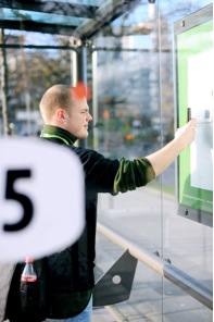
In essence we think of this as a mix of Facebook and FourSquare for Bus Stops, where users leave behind stories, messages and memories while at the same time seeing when the next bus is.

The things can be geo-located through an on-line map of the world where participants can track their object even if they have passed it on. The object can also update previous owners on its progress through a live Twitter feed (which is unique to each object entered into the system).

Einar Hougen, project manager in Kolumbus, states: “When we learned about this exciting UK research project, we instantly recognized the parallels to our own QR tagging of bus stops, which we believe is the largest adaptation of QR codes of this kind in Norway to date. Scanning a QR code at a Kolumbus bus stop gives instant access to current departure times, right on your mobile phone.

In Kolumbus, we are happy to support this research project by sharing our QR mechanism and allowing all our bus stops to be accessible in the tales of things world of objects. Via our tech blog, next.kolumbus.no , we know there are many tech savvy users among our travellers. This will give them the opportunity to join this project, -and hopefully have a bit of fun at the same time!”

ABOUT KOLUMBUS

Kolumbus is the public transport company for Rogaland county, Norway, serving the public with bus and high speed boat routes in the areas of Stavanger, Haugesund, the Fjords, Dalane and Jæren.

For more information on Kolumbus visit http://www.kolumbus.no/

http://next.kolumbus.no/2011/02/04/talesofthings/ and of course you can tag your own objects, places, spaces or bus stops via Tales of Things.