Google Maps Realtime radiation Japan Map

Realtime Radiation Japan Map

Realtime radiation data collected via the System for Prediction of Environment Emergency Dose Information(SPEEDI)This Results are the maximum values of the space those ratedistributions shown from local governments in the latest updated date and time.

With Helicopter over the Japanese Nuclear Plant – scary apocalyptic scene

Helicopter video of Japan’s troubled Fukushima Nuclear plant from yesterday indicates how extensive the damage at the plant is from the earthquake, tsunami, and subsequent explosions.

According to reports, the video was shot about 32 hours ago by a Tokyo Electric Company employee in a Japanese Self-Defense Helicopter surveying the plant. The editors of the video highlight the Fukushima 4 nuclear reactor, which holds the spend fuel rods and looks absolutely destroyed.

It’s a rare up-close view of the plant we’re now only seeing from a long-range for safety reasons and it’s an extremely disheartening one.

Google Earth: Post-earthquake images of Japan

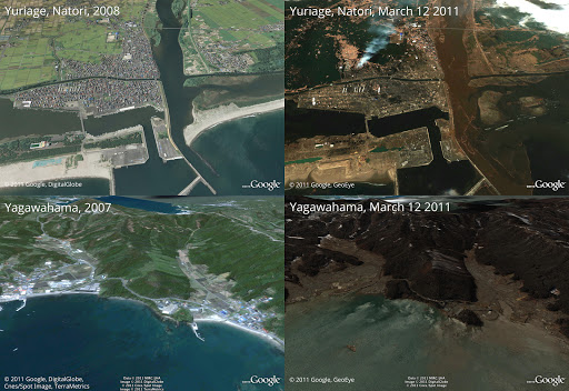
In response to the devastating earthquake and subsequent tsunami that struck Japan, we’ve worked with our satellite imagery providers to get the latest available data of the areas affected most.

To view this high-resolution imagery, courtesy of our partners at GeoEye, download this KML file and explore it in Google Earth. You can also explore the imagery with Google Maps, or have a look at this Picasa album of before-and-after shots. Here’s a sample:

Before and after the earthquake and tsunami. Above is Yuriage in Natori, below is Yagawahama; both are in Miyagi prefecture. High-resolution version of this photo.

We’re working to provide this data directly to response organizations on the ground to aid their efforts. We hope this new updated satellite imagery is valuable for them as well as everyone else following this situation to help illustrate the extent of the damage.

You can find more information regarding the disaster and resources for those in need at our Crisis Response page in English and Japanese. You can also follow @earthoutreach on Twitter to stay up to date with our mapping and imagery efforts.