Google Earth and London in 3D

On April 29, the eyes of the world will focus on London for the royal wedding of Prince William and Catherine Middleton, and the U.K. will deliver a royal celebration that will capture the imagination of a global audience. We’re doing our part too: following last week’s announcement of new aerial imagery for London, we’re expanding our 3D imagery of central London’s buildings and trees in Google Earth—including the entire royal procession route.

With this new 3D data covering the royal procession route, you can indulge yourself in a “royals’-eye” view to see the same sights that William and Catherine will see. Upon departing Westminster Abbey, you’ll pass the Houses of Parliament and Big Ben, the famous ministries on Whitehall and the Prime Minister’s residence at 10 Downing Street. Traverse Horse Guards Parade, and from there, you can travel down The Mall—with 3D trees lining the route—and see Buckingham Palace standing proudly at the finish.

This new 3D imagery isn’t limited to the royal parade route. Thousands of buildings are available, so people from around the globe can digitally experience the beauty of London. You can view buildings such as the British Museum, a treasure trove of historical artifacts, Goodge Street tube station, where General Eisenhower commanded allied forces in WWII, and Shaftesbury Avenue, the historical theatre district of London.

What’s more, we’ve also turned St James’ Park, Green Park and Hyde Park into a 3D lush green carpet, thanks to the help of our friends at the Royal Parks. We’ve modeled five different species of trees, and virtually planted more than 12,000 individual trees (available in Google Earth 6).

To see all the landmarks and greenery in Google Earth, check the 3D buildings box in the left-hand panel under “Layers,” type “London” in the search bar on the top left and use the navigation controls in the upper right to zoom in, spin around and tilt the view. Or you can go to Earth View on Google Maps in your browser.

Since moving to London from Leek, in Staffordshire, I’ve grown to appreciate all the royal and historic landmarks in the capital. So whether you’re standing near me and millions of my fellow Britons on the Mall on April 29 to catch a glimpse of the happy couple, or enjoying the spectacle from home, I hope this new 3D data for London brings you closer to this wonderful city.
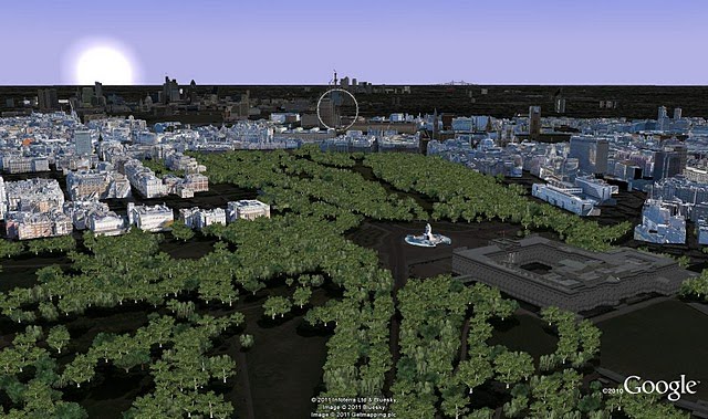
A preview of the sunrise on April 29

Engineering a network in Haiti with Google Earth

In the time since the tragic earthquake in Haiti 14 months ago, we’ve seen a variety of uses of Google Earth to help cope with the event in various ways.

Today we’re looking at how the Church of the Resurrection in Kansas City is using Google Earth to prepare for an upcoming relief trip to the country.

Last year, the church sent 15 teams to Haiti to help repair and rebuild various facilities including churches, schools, medical clinics, and more. However, the teams had a very difficult time communicating with their support systems in the US due to poorly-operating internet connections and wifi.

Last April, Clif Guy went down to help troubleshoot and repair/upgrade internet service in the Methodist guest house in Port-au-Prince so that subsequent teams would be able to stay in communication. During that trip and over the next 6 months he made major improvements and through the process learned a great deal about ISPs in Haiti and the challenges of dealing with intermittent service and intermittent availability of electricity.

This weekend he’s heading back down to Haiti to install network infrastructure and Internet connections in five Methodist buildings in the small town of Petit Goave, on the coast 42 miles west of Port-au-Prince. One of the five buildings is a school (College Harry Brakeman) where they will also be setting up a computer lab for use by high school students. Since Internet connections are very expensive in Haiti, it’s much more economical to install a primary and backup connection and then distribute the connections to the five buildings via radio links rather than purchase a separate connection for each building.

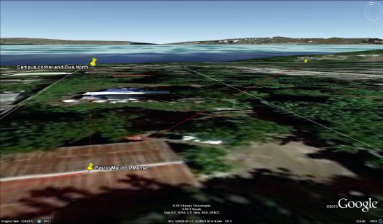
Working with a volunteer (retired manager from AT&T) who is their advance person in Petit Goave, they used Google Earth to mark the locations of the facilities that need Internet access. Once they had locations identified, they were able use Earth to perform a virtual site survey – distance between buildings, building elevations, terrain profiles along the paths between buildings, etc. in order to engineer a building-to-building wireless network. He chose a central location on the highest ground and with the best electrical power to be our network hub. Using Earth and some simple trigonometry he was able to select directional antennas that will allow them to establish the links from the hub to the other buildings with the minimum number of radios.

petit-goave.jpg

It’s an impressive piece of work. The files aren’t as complex as many that we’ve shown you over the years, but the simple fact that they were able to do so much planning from so far away because of Google Earth shows just how useful it can be.

If you’d like to view their plans in Google Earth, you can download the KMZ file here. Buildings are marked with yellow push pins. Radio links are marked with red paths.