As independent interactive mapping experts, Earthware prides itself in making recommendations to clients on the best mapping platform to use for their specific project. Whilst we consider a number of factors of each mapping platform, a key factor is the performance of each mapping platform, both in speed of download and also speed of displaying information on the map.
Recently Bing has released a new version of their AJAX map control, specifically mentioned improvements to the mobile experience and performance as two of their new features. In this article,Earthware will share our experiences comparing the performance of Bing Maps AJAX version 7 with the previous version 6.3.
Download sizes
The first performance metric we have compared is how long each version takes to download the files it needs to display a basic map. This is primarily affected by the size of the files specific to each platform downloads to the client’s browser. We tested both the current, and previous, versions of the Bing Maps platform and included the file sizes of all the javascript, css and image files needed for a basic map to be displayed. The chart below shows the results of these tests.
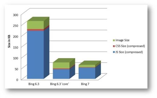
The diagram above shows just how large a difference in file size there was to load version 6.3 when compared to the reduced feature Bing Maps version 6.3 “core” control. However the latest Bing Maps release 7 employs a much smaller download requirement due to the decrease in file size and clearly now leads the field when compared to its predecessors.
With various research studies showing a strong correlation between the time it takes your page to load, and visitor loss rate, combined with the increase in users viewing sites over mobile connections, even the smallest of differences in download sizes are an important consideration.
Map Data Loading Performance
The second performance criteria we have compared is time required for each platform to load, and display, different numbers of pushpins on the map. As this is greatly affected by the browser you are using, we have tested this in the latest (at the time of testing), non-beta, version of each of the major browsers. We have tested Bing Maps version 7 versus Bing Maps version 6 allowing us to show the progress of the Bing Maps platform between version.
The test conducted recorded how long it takes to add 1, 10, 100, 500 and 1000 pushpins to the map. Whilst plotting 1,000 pushpins on the map is probably not a sensible idea from a usability point of view, it does help demonstrate how well each platform reacts under pressure.
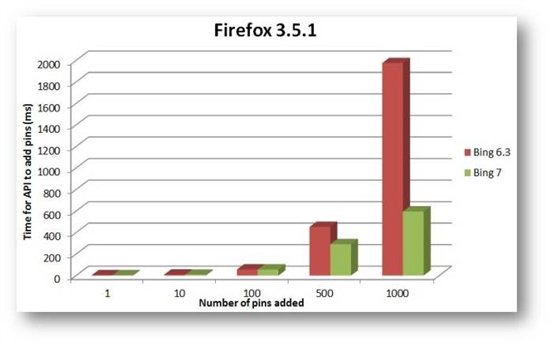
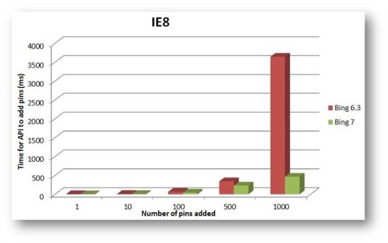
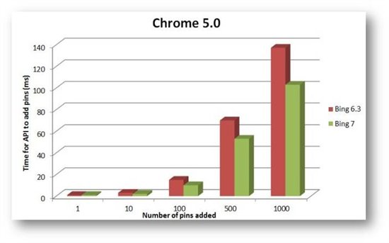
These charts clearly demonstrate that Bing Maps version 7 is a significant improvement in performance over its predecessor. It clearly demonstrates that irrespective of the browser, the performance order of the two different versions is consistent with Bing Maps version 7 outperforming the other 6.3 in the test (and especially so in IE8 and Firefox).
What do these results show?
Although the two performance factors compared in these tests are not the only performance factors worthy of consideration, these results are clearly indicative of relative performance. If performance is a key factor when choosing a mapping platform, these results would certainly indicate that the recent commitment by the Bing Maps development team to improve performance means that Bing Maps appears to lead the way in AJAX mapping platforms.
At Earthware we have recently experienced more pressure from clients to make their mapping work well in mobile environments. These results help us to feel confidence in making a recommendation for the new Bing Maps AJAX platform for projects where performance is the primary consideration.
Try these tests for yourself
If you want to try the map data loading tests for yourself on your own machine the source code is available to download at http://mapperftests.codeplex.com
