Building a healthier, greener Google

When it comes to greening our office buildings, we apply the same focus that we use for any of our products: put the user first. We want to create the healthiest work environments possible where Googlers can thrive and innovate. From concept through design, construction and operations, we create buildings that function like living and breathing systems by optimizing access to nature, clean air and daylight.

Since I arrived at Google in 2006, I’ve been part of a team working to create life-sustaining buildings that support the health and productivity of Googlers. We avoid materials that contain volatile organic compounds (VOCs) and other known toxins that may harm human health, so Googlers don’t have to worry about the air they’re breathing or the toxicity of the furniture, carpet or other materials in their workspaces. We also use dual stage air filtration systems to eliminate particulates and remaining VOCs, which further improves indoor air quality.

Since building materials don’t have ingredient labels, we’re pushing the industry to adopt product transparency practices that will lead to real market transformation. In North America, we purchase materials free of the Living Building Challenge Red List Materials and EPA Chemicals of Concern, and through the Pharos Project we ask our suppliers to meet strict transparency requirements.

We also strive to shrink our environmental footprint by investing in the most efficient heating, cooling and lighting systems. Throughout many of our offices, we’ve performed energy and water audits and implemented conservation measures to develop best practices that are applied to our offices worldwide. To the extent possible, we seek out renewable sources for the energy that we do use. One of the earliest projects I worked on at Google involved installing the first solar panels on campus back in 2007. They have the capacity to produce 1.6 megawatts of clean, renewable electricity for us, which supplies about 30 percent of our peak energy use on the buildings they cover.

With a little healthy competition, we’ve gotten Google’s offices around the world involved in greening our operations. Our internal Sustainable Pursuit program allows teams to earn points based on their office’s green performance—whether it’s through green cleaning programs, water efficiency or innovative waste management strategies. We use Google Apps to help us track progress toward our goals—which meet or exceed the U.S. Green Building Council’s LEED standards—and share what we’ve learned among our global facilities teams.

We’re proud of our latest LEED Platinum achievement for the interior renovation of an office building at the Googleplex. While we have other LEED Platinum buildings in our portfolio, it’s a first for our headquarters and a first for the City of Mountain View. The interior renovation was designed by Boora Architects and built by XL Construction, using healthy building materials and practices. In fact, we now have more than 4.5 million square feet of building space around the world on deck to earn LEED Certification.

via Green blog
Google Earth: Real-time recycling and bus info

We’ve seen a lot of interesting real-time data feeds into Google Earth over the years, the most common being real-time air traffic and a feed of real-time satellite locations.

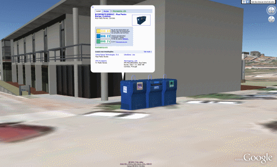
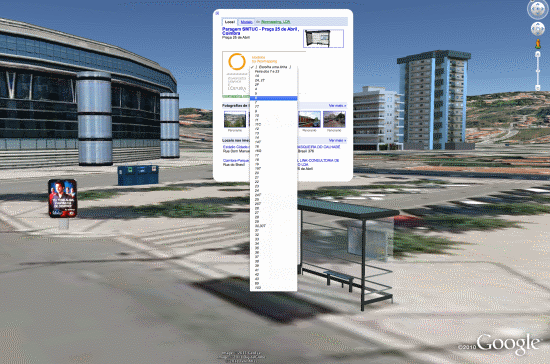
A new set of models from iNovmapping brings it to a different level — stationary objects with real-time data inside. For now, their demonstrations are for bus information, found by clicking on a bus stop, and recycling information, found by clicking on a recycling container. Here are a few screenshots and KMZ files to show you what we’re talking about.

Bus Stop – KMZ

bus.png

Recycling Container – KMZ

recycling.png

What makes these very unique is that the KMZ files aren’t necessary to make them function — they’re just to help you locate the models. In every other real-time product we’ve seen in the past, it’s been managed via a network link. In this case, they’ve added an iframe to the description box on the 3D model itself, and then they can update the information inside of the iframe with up-to-date data about that location. You don’t need to load any external KML files or network links; you can just use the standard “3D Buildings” layer in Google Earth.

If I’m not mistaken, this is the first time we’ve ever seen something like this and the potential for it is huge!

• Find a house on the beach, click it to get real-time rental prices.

• Click on a restaurant to get operating hours for today.

• Click on a house for sale to get info about pricing, open houses, etc.

• Click on a conference center to see what events are happening inside today.

The possibilities are endless, though most of the business ideas mentioned above don’t have 3D models yet. Those that do would then need to find a way to keep the iframed page updated daily, which could be technically challenging and/or time consuming. While there are some issues to work out, this is still quite impressive.

iNovmapping wants to take it even further, though. Some ideas they have for the future:

For example, developers could incorporate feeds of shows in Theaters or of expositions in Museums. This would turn the 3D layer more useful and would create an incentive on the part of the real-estate owners to put their buildings on the GE 3D Layer. Another feature … is the possibility of clicking buildings on the Earth Layer of Google Maps. Everyone likes to see realistic models but we appreciate it evan more if they speak back at us.

They make some great points. While Google Earth is an amazing tool, it’s historically been quite anti-social. Any social games or social apps of any kind end up using the plug-in via the browser, rather than try to do it inside of Google Earth. I tried making a discussion forum inside of Google Earth a few years ago, but it was quite clunky. If (when?) Google ever moves “My Places” into the cloud, that could help with sharing, but until then it’s very limited. It’s great to see a company like iNovmapping try to push the envelope a little bit with methods like this.

University Campus Maps

Amid the height of “March Madness” from the NCAA basketball tournament in the US and the end of the spring break, it’s a good time to look at campus maps and how students are getting around these days. As universities continue to grow, finding the location of a class is becoming more difficult. Fortunately for today’s students, our Geo APIs can help make campus navigation a lot easier.


Northeastern University


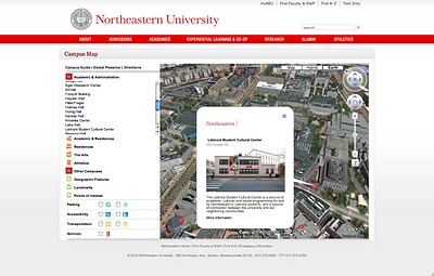
Northeastern University’s campus map is great example of a highly immersive Google Maps and Earth experience. Using the Google Earth Plug-in, users can ‘fly’ in animated 3D from one building to another. The entire campus is custom modeled in 3D (which can easily be done using Google SketchUp). The map also features custom icons, integrated directions, custom balloons with pictures, and even a page where users can see the locations of Northeastern students studying abroad.


University of Washington


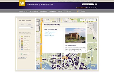
This map is a great example of a seamless custom imagery overlay on top of the Google Maps baselayer. Buildings on the custom UW map are clickable and clicking on one of the buildings brings up a custom styled info window with links to departments held within the building. UW also provides a shortened URL for the building for easy sharing. On the left hand side of the map there is a navigation bar for noteworthy locations such as computer labs, parking, or libraries. Selecting one of the categories will populate the map with a corresponding custom icon. Extra credit points for a custom styled and easy to use UI, both in and around the map.


University of Ottawa


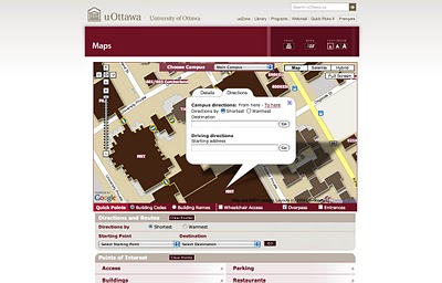
Going to school at the University of Ottawa presents some unique challenges, namely that it can get really cold in the winter. According to the City of Ottawa’s visitors site, the average temperature in January is -10 degrees Celsius! This map aims to make life easier for students by providing integrated direction with two options: shortest route and warmest route. Buildings at uOttawa are interconnected, so students can choose to go between buildings or to brave the cold outside. This map also features custom overlays, custom icons showing the locations of overpasses, and custom info windows.


University of California – San Diego


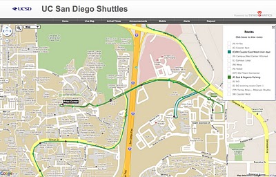
Waiting on your bus can sometimes be huge time sink, which is especially troublesome if you happen to be in the middle of finals. The University of California – San Diego has taken the guess work out of campus transportation by tracking the real time location of all their shuttles on a Google Map. Using the map above, students can see route maps, travel times, and shuttle locations. There’s also an integrated trip planner to help students get around the greater San Diego area.


University of Notre Dame


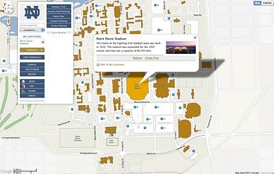
In addition to being a great looking and easy to use full screen map, the University of Notre Dame has added filtering tools to highlight the relevancy of certain buildings at a given time. For example, clicking on the “Game Day” overlay button will highlight Notre Dame stadium (where the games are played) and Bond Hall (where the marching band plays traditional game day concerts), as well as a few other buildings active on game day.

Mobile Campus Maps

As mobile devices and smart phones become more common amongst students on campus, schools like Missouri State University are taking advantage of mobile optimized Google Geo APIs. In February 2010, Chad Killingsworth, Assistant Director of Web & New Media at Missouri State University, posted a story here on the Geo Developers Blog about how his school created a mobile device optimized map for campus buildings, parking and real-time transit system information.