Osama bin Laden compound location in Pakistan

Abbottabad, Pakistan


latitude=”34.169373″ longitude=”73.242539″

The location of Osama Bin Laden’s compound in Abbottabad has been identified by local sources. The compound, that is described as having 4m-6m (12ft-18ft) walls and being eight times larger than other homes in the area, is to the south-east of a Pakistan Military Academy. The satellite imagery shown on this Google Map clearly matches photographs of the compound released by the Pentagon (pdf link from ABC).

Abbottbad resident and Twitter user Sohaib Athar (@ReallyVirtual) Tweeted what he says was the location of the crashed helicopter in the American attack on the compound. The helicopter is being reported as having crashed because of ‘technical failure’.

The New York Times describes the compound as being “a large mansion on the outskirts of the town center, set on an imposing hilltop and ringed by 12-foot-high concrete walls topped with barbed wire.”

Big hat-tips to Ogle Earth and the Google Earth Blog.

Google earth: Imagery Update (and Kansas Basketball)

We’re in the middle of college basketball Madness here in the U.S. and the best is yet to come. Tomorrow night, the Kansas Jayhawks will play the Richmond Spiders in a Sweet Sixteen match-up at the Alamodome in Texas. I’ll proudly admit that I’m a Kansas fan and hoping to see my home team make it to the Finals. But I’m not the only college hoops fan at Google. In fact, our Geo team put together a special page that shows an up-to-date schedule with schools and stadiums.

In our latest imagery push, we (coincidentally) added new imagery of Lawrence, Kansas and a new 3D model of the Allen Fieldhouse, possibly the best basketball venue on Earth. As a longtime Lawrence resident and KU alumnus, I still remember my first games in the “Phog” when I was in junior high school, watching from the upper bleachers. The Fieldhouse has aged well with the new Booth Family Hall of Athletics and the parking additions.


When I’m feeling like I need even more of a dose of home, it’s also great to be able to check out some of my favorite places back in Lawrence through Google Earth and Google Maps. With the new high-resolution aerial imagery, you can now see many changes including the updates to Memorial Stadium and the large practice fields.


Additional basketball-related updates include Gainesville (Florida), Tallahassee (Florida State), and Manhattan, the Little Apple (Kansas State [5]). We’ve also updated many other locations around the world that can be seen and discovered in our latest batch of published imagery including major updates in Sydney, Tokyo, Stockholm and significant parts of Ireland.

High Resolution Aerial Updates:
USA: Boca Raton, FL; West Palm Beach, FL; Port St Lucie, FL; Crystal River, FL; Ocala, FL; Gainesville, FL; Tallahassee, FL; Valdosta, GA; Savannah, GA; Jackson County, GA; Bedford County, PA; Cumberland County, PA; Manhattan, KS; Topeka, KS; Lawrence, KS
Wales: Northern Half
Scotland: Hawick
Japan: Tokyo; Kawasaki; Yokosuka
Australia: Sydney, Brisbane, Canberra

Countries/Regions receiving High Resolution Satellite Updates:
Antarctica, United States, Canada, Mexico, Cuba, Haiti, Dominican Republic, El Salvador, Panama, Bolivia, Paraguay, Brazil, Argentina, South Africa, Madagascar, Namibia, Zimbabwe, Zambia, Angola, Tanzania, Kenya, Burundi, Rwanda, Democratic Republic of the Congo, Uganda, Ethiopia, Sudan, Central Africa, Niger, Ivory Coast, Togo, Liberia, Senegal, Morocco, Algeria, Tunisia, Egypt, Israel, Jordan, Syria, Saudi Arabia, Bahrain, Qatar, United Arab Emirates, Kuwait, Yemen, Iran, Pakistan, Tajikistan, India, Bangladesh, China, Myanmar, Thailand, Taiwan, North Korea, Japan, Mongolia, Indonesia, Australia, New Zealand, Russia, Georgia, Armenia, Azerbaijan, Turkey, Greece, Bulgaria, Romania, Ukraine, Hungary, Austria, Poland, Croatia, Italy, Germany, Switzerland, France, Spain, Portugal, Ireland, Norway, Sweden, Finland, Greenland

These updates are now available in both Google Maps and Google Earth. To get a complete picture of where we updated imagery, download this KML for viewing in Google Earth.

Imagery from the landslides in Brazil

Back in mid-January, Rio de Janeiro, Santa Catarina and other areas of Brazil expereinced devastating mudslides as the result of nearly 10 inches of rain in a single day. The landslides are reported to have killed nearly 1000 people, and have left at least 8,700 homeless. Since then, NASA has been attempting to capture fresh imagery of the area but has been unable to due to satellite imagery’s biggest nemesis — clouds.

The situation is similar to the flooding in Pakistan last year; Google wanted to provide imagery of the area to assist those that were trying to help, but they were unable to get any for quite a while due to persistent cloud cover.

Fortunately, clouds broke a few days ago and NASA’s EO-1 satellite was able to capture some remarkable images of the area.

brazil.jpg

They’ve also provided a KML file 
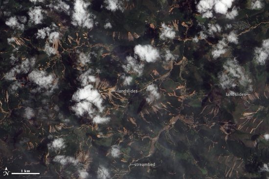
with imagery of the mudslides, for those that wish to view the imagery inside of Google Earth.

UPDATE: After we published this post, DigitalGlobe sent us a great PDF they put together showing before/after shots of some of the affected areas. Download the PDF here.