Richer photo support in the Google Buzz API

You’ve already been able to simply include a photo in a Google Buzz post using the Buzz API. Today we’re making it much easier to add photos to Buzz posts. Additionally, using Picasa as the photo repository, you’ll now be able to wield the Buzz API to take all sorts of other actions on behalf of the user:

  • Create a new album
  • Get an album
  • Update an album’s metadata
  • Delete an album
  • List a user’s albums
  • Upload a new photo
  • Get a photo
  • Update a photo’s metadata
  • Delete a photo
  • List a user’s photos

Accessing a photo entry through the Buzz API is just as easy as getting an activity. The form for retrieving an activity is:

https://www.googleapis.com/buzz/v1/activities/{userId}/@self/{activityId}

With just a few alterations, we get the form for retrieving a photo:

https://www.googleapis.com/buzz/v1/photos/{userId}/@self/{albumId}/@photos/{photoId}

With live data, it would look like the following URL:

https://www.googleapis.com/buzz/v1/photos/farago/@self/5251364904403459921/@photos/5251366163678993586?alt=json&prettyprint=true

Browse to that address and you’ll get data that will point to this Picasa photo:
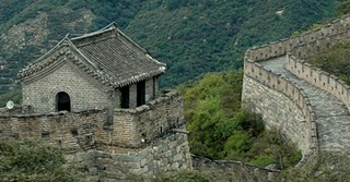
(Photo by Julie Farago, used under the Creative Commons Attribution Non-Commercial Share-Alike license)

The read-only endpoints will return public data without authentication. For authenticated access to the photos endpoints, you must be granted an OAuth token for the user with both the Buzz and Photos API scopes. For existing users, you will need to discard the OAuth tokens scoped to the Buzz API and request authorization to both scopes. More details can be found on the Google Buzz API documentation site.

Photos are an essential part of social applications. We expect these new capabilities will allow you to enrich your user’s experience with a minimum of fuss. As always, please swing by the Developer Forum to let us know what you think. And if you haven’t already, start using the APIs console to track your API usage and other coolness.
360 Panoramas Now Part of Google Earth Photos Layer

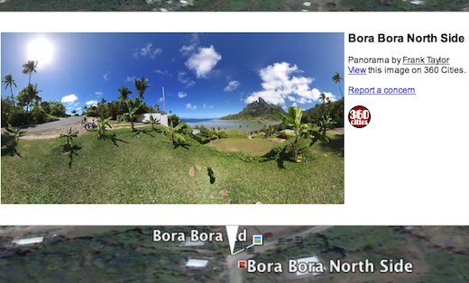
Google has upgraded the Photos layer in Google Earth to not only include the millions of geo-tagged photos from Panoramio, but also to include 360 degree panoramas from 360cities.net. The 360 photos were previously viewable in Google Earth if you opened the Gallery layer folder and turned on the 360Cities layer. But, now everyone can find the panoramas with the default Photos layer. The regular 2D photos still appear as little blue icons as you zoom into a place. Now, if 360 panorama photos are available for that place, you will also see little red square icons as well. Click on a red icon and you’re presented with a 2D view of that location in the pop-up window and you can click the photo to fly into the 360 panorama right in Google Earth.

gebora360.jpg

I’m a big fan of 360 panoramas which give you a full immersive experience of a photo location – you can look in all directions, including up and down. During our first year of the Tahina Expedition I have produced many 360 panoramas of places in the Caribbean, the Panama Canal, Galapagos, the French Marquesas, Bora Bora, Tonga, and more (see recent 360s of Tonga, see all of the panoramas for Tahina Expedition). Now everyone can find 360 photos like these, and those done by thousands of photographers around the world right in the Photos layer.

I’m thrilled to see 360 panoramas, and 360Cities.net, get more visibility. Jeffrey Martin, who started 360Cities, says that there are more than 60 thousand 360 images in the new Google Earth layer. Congratulations Jeffrey! Kudos to Google for making these photos more accessible! I hope they’ll take the next step and add them to the Photos layer in Google Maps as well.

See LatLong blog post about the layer changes.gebora360.jpg

New panoramic photos in Google Earth


Viewing photos in Google Earth has long been a popular activity for avid virtual globe-trotters. It’s one of the best ways to “visit” places all over the world without paying for a plane ticket or getting jet lag. Today, the Google Earth photo viewing experience just got better with the addition of panoramic images.

People using Google Earth will find a new “Photos” layer that includes not only the existing 2D photos from the Panoramio community, but also panoramic photos from around the world contributed by users of 360cities.net. These high-resolution panoramic photos are marked in Google Earth as red square icons. When you click on one of these icons, an info bubble containing an image appears, and clicking on the image again will take you into our photo viewing mode. You can then look around in 360-degree views and experience the place as if you’re standing right at the center of it.

new “Photos” layer on Google Earth
info bubble on Google Earth

These panoramic photos are shot by average people just like you and me. To contribute your panoramic photos, visit 360cities.net. We invite all users to become part of the community and mark your photo journey in Google Earth.

Check out some of the beautiful images now available right in Google Earth.

Golden Gate Bridge on Google Earth and on 360cities.net
Gapang Beach, Pulau Weh, Indonesia on Google Earth and on 360cities.net

Lion’s Head, South Africa on Google Earth and on 360cities.net

Diving New Caledonia Amedee Island on Google Earth and on 360cities.net

Umag Asanas, Istria at sunset on Google Earth and on 360cities.net

Panthéon and Foucault pendulum, Paris on Google Earth and on 360cities.net

Posted by Wei Luo, Senior Geo Data Strategist