Google Earth: Imagery Update Last Week of August

The Google Earth and Google Maps Imagery Team just published a new batch of aerial and satellite imagery, and as always, there’s all kinds of fascinating sites and features to check out.

We’re now deep into the dog days of summer. When I was growing up in Chicago, my siblings and I would be acting a bit stir crazy by this time in our summer breaks. So what did our wise parents do? They’d pile us into the confined space of the family car and proceed to road-trip it for a few weeks. My parents are history buffs, so our destination spots were typically of historical significance. To commemorate these fond memories, in this post we’ll look at locales seen in our newly published imagery that would typically fit the destination profile of my family.

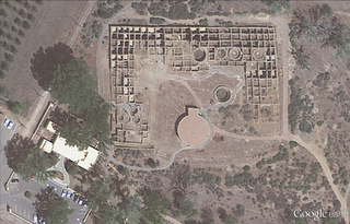
Our first example seen below is from high-resolution aerial imagery acquired this past June. The locale is a U.S. National Park located in San Juan County, New Mexico and contains 11th to 13th century structures constructed by the Anasazi Indians, the ancestors of the more commonly known Pueblo Indians. This site is included in the UNESCO list of World Heritage Sites.

Aztec Ruins National Monument, New Mexico

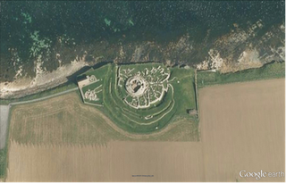
Family vacations outside of the U.S. happened on occasion and when they did, my dad’s fondness for Led Zeppelin would often lead us to any castle or related ruin in sight. In this aerial image, we can see the Broch of Gurness village located on the northwestern coast of Mainland Orkney, Scotland. The top of the central, circular broch structure has collapsed, and we can see the settlement remains that encircle the broch. The site dates to at least 60 AD.

Broch of Gurness, Scotland

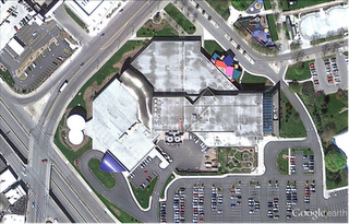
Finally, if we were good children and did not get our peanut butter sandwiches all over the car upholstery, we might be treated to visit a place such as the National Toy Hall of Fame, located in the Strong National Museum of Play, Rochester, New York. Some of the 47-and-counting enshrined toys include road-trip friendly icons such as the stick, cardboard box, ball, and of course Silly Putty!

National Toy Hall of Fame, Rochester, New York

Do you have a place you love for which you’d like to receive a notification when the Earth and Maps Imagery team updates the site? We’ve got just the tool: The Follow Your World application!

As always, these are but a few examples of the types of features that can be seen and discovered in our latest batch of published imagery. Happy exploring!

High Resolution Aerial Updates:

USA: Abilene, TX; Avenal, CA; Bakersfield, CA; Big Spring, TX; Bowie, AZ; Buckeye, AZ; Carlsbad, NM; Casa Grande, AZ; Columbia, MO; Dalhart, TX; Dayton, OH; Des Moines, IA; Farmington, NM; Ft Worth, TX; Joplin, MO; Junction, TX; Monahans, TX; Nogales, AZ; Omaha, NE; Paducah, KY; Payson, AZ; Rochester, NY; Sacramento, CA; Sioux City, IA; Tulsa, OK; Visalia, CA; Wilcox, AZ

Scotland: Aberdeenshire, Clova, Islay, Jura, the Orkney Islands, and the Shetland Islands

Sweden: Dalarnas Län, Gotlands Län, Norrbottens Län, Oland, Örebro Län, Västerbottens Län, and Västernorrlands Län

Countries/Regions receiving High Resolution Satellite Updates:

Albania, Algeria, Angola, Antarctica, Argentina, Armenia, Australia, Austria, Azerbaijan, Bahrain, Bangladesh, Benin, Bhutan, Bolivia, Bosnia and Herzegovina, Botswana, Brazil, Bulgaria, Burkina Faso, Burundi, Cambodia, Cameroon, Canada, Cape Verde, Central African Republic, Chad, Chile, China, Colombia, Cuba, Côte d’Ivoire, Democratic Republic of the Congo, Djibouti, Dominican Republic, Ecuador, Egypt, Equatorial Guinea, Eritrea, Ethiopia, Fiji, Finland, France, Georgia, Ghana, Greece, Greenland, Guatemala, Guinea, Guinea-Bissau, Honduras, Hong Kong, Iceland, India, Indonesia, Iran, Jamaica, Japan, Jordan, Kazakhstan, Kenya, Kuwait, Laos, Lesotho, Liberia, Madagascar, Malawi, Malaysia, Mali, Marshall Islands, Mauritania, Mexico, Mongolia, Morocco, Mozambique, Myanmar, Namibia, Nepal, Netherlands Antilles, New Zealand, Nicaragua, Niger, Nigeria, North Korea, Norway, Oman, Pakistan, Panama, Papua New Guinea, Paraguay, Peru, Philippines, Poland, Republic of the Congo, Romania, Russia, Rwanda, Saudi Arabia, Senegal, Serbia, Singapore, Somalia, South Africa, South Korea, Spain, Sri Lanka, Sudan, Svalbard, Sweden, Switzerland, Syria, Tanzania, Thailand, Togo, Turkey, Turkmenistan, Uganda, Ukraine, United Arab Emirates, United Kingdom, United States, Uruguay, Venezuela, Vietnam, Wallis and Futuna, Western Sahara, Yemen, Zambia, and Zimbabwe
Google Earth: The largest Street View update


Google has just pushed out a major update to their Street View imagery, in what they’re calling their biggest update yet.

This update has seen imagery updated/added to 13 countries that already had some degree of Street View imagery, including Denmark, Ireland, Italy, Spain, Netherlands, Norway, Sweden, Romania, South Africa, Taiwan, Japan, the United States, and the United Kingdom.

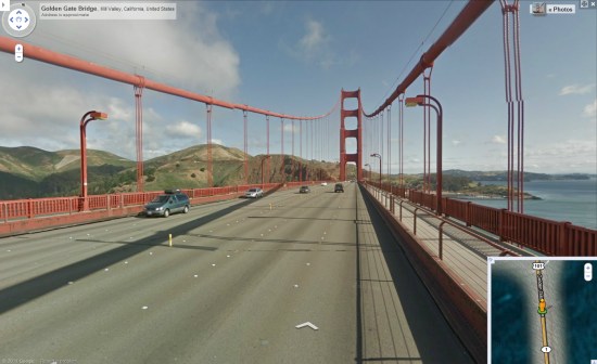
Part of that includes higher resolution images in parts of California (San Francisco Bay Area, Los Angeles and San Diego), allowing you to see amazing images like this one of the Golden Gate Bridge.


golden-gate.jpg 

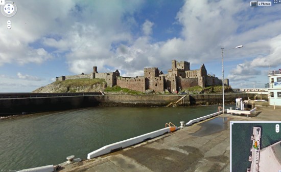
Also included in this imagery are a few new islands: Jersey, off the coast of France, and Isle of Man, located in the Irish Sea. Here is Peel Castle, located on Isle of Man (via Google Maps Mania):

peel.jpg 

Finally, don’t forget that the Street View mode was greatly enhanced with the release of Google Earth 6, making it much easier to browse this kind of imagery from within Google Earth. To enter one of these areas, or any other Street View-enabled location, simply drag the “Peg Man” from the controls in the upper right corner onto the globe.

New Google Imagery – Week of May 16th

The Google Earth and Google Maps Imagery Team has just published its latest batch of satellite and aerial imagery, and as always, there are all kinds of fascinating sites and features to check out.

It’s mid-May and summer is just around the corner. That means vacation! And since many of us like to head to the water for our leisure time, we’ve compiled examples of a few coastal areas that have received updated imagery in our latest release.
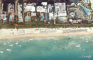
In the States, premiere beach vacation spots include the coral-sand beaches that line Miami, Florida. Below is a stretch of the world-famous South Beach within the City of Miami Beach’s City Center district. This high-resolution aerial image was taken this past March, during Spring Break.


44th St. Beach, Miami, Florida


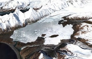
If hot, crowded beaches aren’t your thing, there are many cooler places (literally) you could spend your leisure time exploring. Below is a high-resolution aerial image from this past April of Bear Glacier in the Kenai Fjords National Park, Alaska. In this image, you can see the glacier toe as well as the ice, meltwater, and debris it deposits. This valley outflow glacier is sourced from the Harding Icefield, the largest icefield contained entirely within the United States. If you’re viewing this in Google Earth, be sure to use the Historical Imagery time slider to view how the glacier’s size has changed over time.

Bear Glacier, Kenai Fjords National Park, Alaska


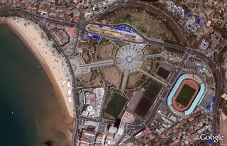
Finally, here’s a recent satellite image of the entertainment center in the bustling coastal city of Qingdao, in the Shandong Province, China. The city was named China’s most livable city in 2009, and from the image below you can understand why; there are many places to enjoy such as beaches, sport complexes, and the beautiful public space, Hui Quan Square. Indeed, a nice place to visit and explore on your next summer vacation – whether it’s in-person or online. When viewing this area in Google Earth or Maps, you can also explore other parts of the image, such as the finishing touches being put on the Haiwan Bridge, the world’s largest water bridge, spanning 26.4 miles.


Hui Quan Square, Qingdao, China


Do you have a place you love for which you’d like to receive a notification when the Earth and Maps Imagery team updates the site? We’ve got just the tool: The Follow Your World application!

As always, these are but a few examples of the types of features that can be seen and discovered in our latest batch of published imagery. Happy exploring!

High Resolution Aerial Updates:
USA: Myrtle Beach, Miami, Palm Beach, Lake City, Lynchburg, Lenoir, Dallas, Grand Rapids, Anchorage, Kenai, Tyonek

Countries/Regions receiving High Resolution Satellite Updates:
Albania, Algeria, Angola, Antarctica, Argentina, Australia, Austria, Azerbaijan, Bahamas, Bangladesh, Belarus, Belize, Benin, Bhutan, Bolivia, Bosnia and Herzegovina, Botswana, Brazil, Bulgaria, Burkina Faso, Canada, Cape Verde, Chad, Chile, China, Colombia, Costa Rica, Croatia, Cuba, Cyprus, Côte d’Ivoire, Democratic Republic of the Congo, Djibouti, Dominican Republic, Ecuador, Egypt, El Salvador, Eritrea, Estonia, Ethiopia, Fiji, Finland, France, French Guiana, Gambia, Germany, Greece, Grenada, Guam, Guatemala, Haiti, Hong Kong, Hungary, Iceland, India, Indonesia, Iran, Ireland, Israel, Italy, Jan Mayen, Japan, Jordan, Kazakhstan, Kenya, Kuwait, Laos, Latvia, Lebanon, Lesotho, Lithuania, Madagascar, Malawi, Malaysia, Mali, Mauritania, Mexico, Moldova, Mongolia, Morocco, Mozambique, Myanmar, Namibia, Nepal, Netherlands, New Caledonia, New Zealand, Niger, Nigeria, North Korea, Norway, Pakistan, Palmyra Atoll, Panama, Papua New Guinea, Paraguay, Peru, Philippines, Poland, Portugal, Qatar, Romania, Russia, Samoa, Saudi Arabia, Senegal, Serbia, Slovakia, Slovenia, Somalia, South Africa, Spain, Sri Lanka, St. Helena, St. Vincent and the Grenadines, Sudan, Suriname, Svalbard, Swaziland, Sweden, Switzerland, Syria, São Tomé and Príncipe, Taiwan, Tanzania, Thailand, Trinidad and Tobago, Tunisia, Turkey, Uganda, Ukraine, United Arab Emirates, United Kingdom, United States, Uruguay, Venezuela, Vietnam, West Bank, Western Sahara, Yemen, Zambia, Zimbabwe

These updates are now available in both Google Maps and Google Earth. To get a complete picture of where we updated imagery, download this KML for viewing in Google Earth.