Follow the Mission Blue expedition to Salas y Gomez

While many of us would like to embark on a voyage across the ocean, we can’t all be Frank Taylor. Fortunately, Google Earth provides a great way to explore places virtually, such as with the latest installment in the “Mission Blue” series.

Last month, we showed you Mission Blue’s tracking of the gulf oil spill recovery effort. This month, they’re heading east from Easter Island to the tiny island of Salas y Gomez in an effort to do some research in the largely unexplored waters around the island.

salas.jpg

As with the gulf spill mission, they’re providing updates in a variety of ways. You can track it by finding the blue ship icon near Easter Island (be sure the “Places” layer is turned on), by downloading this KML file, or you can track them in the Google Earth Gallery using the Google Earth Plug-in.

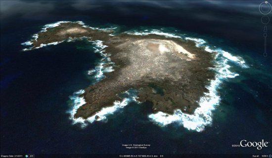
Salas y Gomez was updated in the most recent imagery update, featuring imagery that is just a few weeks old. It’s a bit fuzzy, but it’s much better than what they used to have there. To check out the island for yourself, you can fly there using
this KML file.

For more, check out the full entry on the LatLong Blog or read stories from the crew on the Mission Blue News Watch blog.

New Google Earth Imagery – February 24

Google has just pushed out some fresh imagery to various parts of the world, with thanks going to sharp-eyed GEB reader ‘Andreas’ for being the first to point it out to us!

hohenfels.jpg

The full extent of the update is still unknown, but as is usually the case, you can use Google Maps to determine for sure whether or not a specific area is fresh. This new imagery isn’t in Google Maps yet, so you can compare Earth vs. Maps to see what’s new; the fresh imagery is already in Google Earth, but the old imagery is still in Google Maps. If you compare the two side-by-side and they’re not identical, that means that you’ve found a freshly updated area in Google Earth!

[UPDATED — 24-February, 11:00am EST]

  • Australia: Melbourne — thanks ‘David’
  • Bosnia Herzegovina: Various areas — thanks ‘Andreas’
  • Croatia: Various Areas — thanks ‘Andreas’
  • Germany: Hohenfels, Marl — thanks ‘Andreas’
  • Norway: Various areas — thanks ‘Andreas’
  • Romania:Various areas — thanks ‘Andreas’
  • Sweden: Areas along the western part of the country — thanks ‘John’
  • UK: London — thanks ‘Carl’
  • United States: Illinois (west central) — thanks ‘KennyB’

If you find any other updated areas, please leave a comment and let us know!

3D Infographic Brick by LEGO Brick

It might be pushing the term “infographic” when the piece at hand is actually a LEGO sculpture jutting out from a wall, but Samuel Granados’s maps, showing immigration and emigration in various regions by stacking LEGO bricks to different heights, are the rare intersection of data porn and LEGO porn nonetheless.