In a bit of a surprise move, rather than allowing us to discover new imagery in Google Earth, Google has pre-announced an imagery update that is due out later this week.
[UPDATE: The imagery is now live in Google Earth. See the bottom of this post for a list of updated areas.]
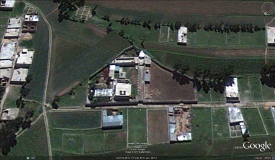
Part of the update will include some high-quality imagery from Abbottabad, Pakistan, which was captured in May, 2010. They’re offering a preview of that imagery via this KML file.
In addition, the very new GeoEye imagery of Abbottabad that we mentioned yesterday will be available in the historical imagery feature of Google Earth soon. Remember, historical imagery is sometimes newer than the base imagery.
It sounds like it’s quite a major update, and we’ll be sure to let you know when it goes live. Here is the full list of areas that will be getting fresh imagery:
High Resolution Aerial Updates:
USA: Brookshire, TX; Brownsville, TX; Dallas, TX; Ft Stockton, TX; Hebbronville, TX; Houston, TX; Laredo, TX; McAllen, TX; Milwaukee, WI; Padre Island, TX; Wharton, TX; Zapata, TX;
Australia: Central Coast, New Castle, and Salamander Bay
Norway: Buskerud, Fredrikstad, and OsloCountries/Regions receiving High Resolution Satellite Updates:
Algeria, Angola, Antarctica, Antigua and Barbuda, Argentina, Australia, Austria, Bangladesh, Belarus, Benin, Bolivia, Brazil, Burundi, Cameroon, Canada, Central African Republic, Chad, Chile, China, Colombia, Costa Rica, Croatia, Czech Republic, Democratic People’s Republic of Korea, Democratic Republic of the Congo, Denmark, Djibouti, Dominican Republic, Egypt, Eritrea, Estonia, Ethiopia, Finland, France, Georgia, Germany, Greece, Greenland, Grenada, Guadeloupe, Guinea, Haiti, Honduras, Hungary, India, Indonesia, Iran, Ireland, Israel, Italy, Japan, Jordan, Kenya, Kuwait, Latvia, Lebanon, Lesotho, Lithuania, Madagascar, Malawi, Mali, Mexico, Mongolia, Morocco, Mozambique, Myanmar, Namibia, Nepal, Netherlands, New Zealand, Niger, Nigeria, Norway, Oman, Pakistan, Paraguay, Peru, Philippines, Poland, Portugal, Republic of Korea, Romania, Russia, Saudi Arabia, Senegal, Serbia, Seychelles, Sierra Leone, Slovakia, Somalia, South Africa, Spain, Sri Lanka, Svalbard, Swaziland, Sweden, Switzerland, Syria, Taiwan, Tanzania, Thailand, The Gambia, Tunisia, Turkey, Uganda, Ukraine, United Arab Emirates, United Kingdom, United States, Uruguay, Venezuela, West Bank, Western Sahara, Yemen, Zambia, Zimbabwe