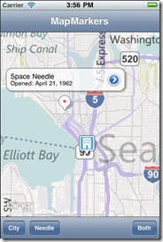
Today, we’re excited to announce a new Bing Maps iOS SDK. This new SDK gives developers a set of Objective C classes to develop iPhone and iPad applications within Xcode, along with documentation and several sample projects to help them get started quickly. The iOS map control supports Bing’s road, aerial and hybrid aerial map styles, and includes the ability to add pushpins to the maps and access the user’s location via the GPS to locate the phone on the map.

In keeping with our focus on performance across the Bing Maps platform, we have separated the Bing Maps Controls from the Bing Maps services to lighten the load. This means you can use the Bing Maps iOS Control in conjunction with the Bing Maps REST Service (Geocoding and Routing) to build a fully featured mobile map application. Additionally, you can hit Bing search services to pull local listing information.

And as always, developers can integrate Bing Maps into consumer-facing mobile applications for free (you can read the fine print here). We think you will find that the terms of use are less restrictive than what you find with the Apple Map Kit, with no sacrifice in functionality.
The launch of the iOS SDK goes a long way toward rounding out Bing’s toolset for mobile developers. In addition to the iOS SDK, developers can also use the Bing Maps SDK for Windows Phone and the community-driven SDK for Android development. Add to these our long list of tools and services for web development and it equals a mapping service with the scale and scope to support a wide range of mapping projects.
Sign up for a free Bing Maps Key, then download the .zip file to get the control and SDK, and you’re off and running!


