In the wake of intense drought, the Horn of Africa is gripped by its worst famine in more than 60 years. Over 12.4 million people across Kenya, Ethiopia, Djibouti and Somalia are threatened with hunger and disease as they are unable to access basic survival means. UN agencies and other humanitarian organizations are rallying to support refugees on the move, particularly to the thousands fleeing Somalia. Valerie Amos, OCHA Emergency Relief Coordinator, has stated that “This will not be a short crisis.” The emergency is expected to persist at least three to four months, and the number of people needing humanitarian assistance could increase by as much as 25 percent. Fresh and accurate maps are among the many critical factors in assessing such a state of crisis, as they provide vital information to facilitate emergency response and planning. Thanks to the efforts of our satellite imagery partner, GeoEye, we now have high resolution imagery of locations with the most pressing humanitarian needs. This has made Google Map Maker community mapping efforts even more effective, by allowing the creation of improved maps over refugee camps in Kenya, Ethiopia and the city of Mogadishu. Volunteers are mapping roads, hospitals, schools, community centers, and water resources, among other vital landmarks. The map data contributed is being shared periodically with the UN agencies engaged in this crisis. Google has also donated 1 million USD to help local and international organizations provide famine and drought relief support in the Horn of Africa.
You can help the Horn of Africa during its time of crisis by creating detailed maps using your local knowledge of places, such as cities, roads, and natural landmarks. If you’re unfamiliar with the region, try pairing up with people who have local knowledge, who can help by reviewing and correcting your edits. To participate in these ways and more, and offer feedback, please join our Africa mailing list and visit the Horn of Africa community mapping site as we all map the way toward crisis relief.
Today, we’re excited to share with our blog readers that the Bing Maps team has updated the Bing Maps World Tour application. The Tour now showcases 153 locations where Bing Maps features new outstanding high-resolution aerial imagery that is being captured and published as part of our Bing Maps Global Ortho imagery program. Using the application, you can view the new aerial imagery through an automated “slide show” mode or explore the locations manually. The imagery is from a special collection referred to as “Geoart” for its unusual, compelling and artistic quality.
What is the Global Ortho program? Launched in the spring of 2010, this program is an ambitious mapping project that aims to provide the Bing Maps platform and consumer web site with 30cm (1 foot) aerial blanket coverage of (initially) the continental United States and Western Europe. A challenge for consumers and enterprise organizations using web mapping services has been that much of the imagery featured there has historically been a patchwork of satellite and aerial imagery of different vintage, quality, clarity and detail. The experience for users of these services has been inconsistent at best, varying by location: while you might expect to find higher resolution aerial images of 15-30cm (meaning that each screen pixel equals 6-12 inches on the ground) over key urban locations, a search in a more rural or remote location would likely yield satellite views of at best half that accuracy and detail. The two below screen captures of Denver and Johnstown, Colorado—locations just 50 miles apart—demonstrate this point.
That is all now changing. The Bing Imagery Technologies team (BITs), located in Boulder, Colorado, has spent more than a year collecting the new Bing Maps imagery, and has been quietly publishing this aerial imagery to the Bing Maps web site. The first of it began appearing in August 2010 and to date, 46% of the project has been captured and roughly 349 blocks equaling 2,771,192 sq kilometers from 37 States, France and Spain have been published, plotted in the below maps. The project is scheduled for completion by June 2012 at which point a refresh cycle will begin to update much of what will already have been collected, with priority placed on locations that have been more subject to change (as opposed to, say, the Mojave Dessert). As its name implies, the Global Ortho program aspires to be truly global, covering the planet with straight down aerial views (ortho images).
What this means to people using Bing Maps and applications built on the Bing Maps platform is that they can trust Bing Maps to provide the same experience regardless of where they search. They will be able to visit any location in the United States or Western Europe online and see it with the same brilliance, resolution and accuracy. 30cm provides a lot of detail! Check out the brilliance of the below image captured over Austin, Texas. Equally important: wherever you are exploring in Bing Maps, you are likely to find CURRENT imagery.
How is Microsoft tackling such an aggressive project? It begins with a business approach that Microsoft is well-known for: partnerships. To collect the imagery, Microsoft is working with aerial mapping organizations that are customers of our UltraCam digital aerial camera business and experts in aerial image collection. Microsoft came into the aerial sensor business in May of 2006 through the acquisition of Vexcel Imaging, GmbH in Austria. Since that time, the UltraCam business has grown to include a commercial line of award-winning and widely adopted aerial camera systems and the UltraCamG, developed specifically for the Global Ortho program and not commercially available. The most important feature of the UltraCamG is that it allows our aerial mapping partners to fly at very high altitudes and capture about 50% more pixels across the flight line than any other digital aerial mapping camera system which translates into time and cost savings.
Then this imagery is delivered to the BITs team in Boulder where it undergoes quality control and is processed to remove the building lean and create the straight down views—“orthos”, as they are called. They are then color balanced so that the color quality is consistent among each view and following this, is delivered to our partner DigitalGlobe—a leading satellite imagery provider—to sell to government and commercial entities for offline use, and stitched to create seamless mosaics for publishing to Bing Maps. This stitching allows you to pan, zoom and scroll through locations in continuous movements.
The storing and processing of this imagery requires a significant amount of computing power. The BITs data compute site provided by DELL has a huge amount of container-based compute and storage power to be able to automate a lot of the things would normally be done manually: currently in excess of 16,500 compute cores and roughly 55 petabytes of storage. Yet this facility runs off hydroelectric power and between this and the DELL design that features evaporative cooling, it is highly-efficient from a power usage effectiveness (PUE) perspective ( 1.03 ).
But enough reading about the Bing Maps Global Ortho program! Check out the video with interviews of key members of the BITs team and lots of stunning examples of the imagery being collected! Then be sure to check out the the Bing Maps World Tour application to see more of this stunning imagery.
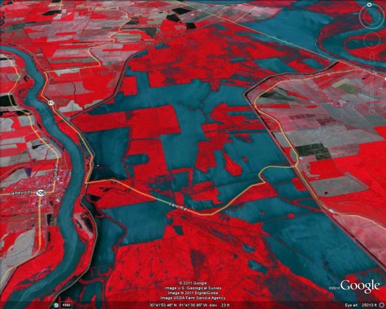
The NASA Earth Observatory has just posted a very powerful false-color image of the flooding that resulted from opening the Morganza spillway last week.
The reason for the false-color in this imagery is to more easily highlight the flooded areas. Specifically:
The false-color images combine infrared, red, and green wavelengths to help distinguish between water and land. Clear water is blue, and sediment-laden water is a dull blue-gray. Vegetation is red; the brighter the red, the more robust the vegetation. Gray patches away from the center of the floodway are likely farm fields that have recently been burned or cleared.
To see it for yourself, you can download this KML file. Be warned that it’s pulling a 4MB image, so it’ll take a few seconds to load.


 Be warned that it’s pulling a 4MB image, so it’ll take a few seconds to load.