Planning new roads with Google Earth

If you watched the second episode of the Geospatial Revolution that we posted a few months ago, you may remember how the city of Portland was making excellent use of mapping technologies such as Google Earth to help with city planning.

I’m reminded of that story when looking at what the city of Douglasville, Georgia is doing as they prepare to undertake a massive highway widening and reconstruction project. The Highway 92 Project uses similar tools as other projects, with a variety of charts, PDFs and Word documents. However, they also are using Google Earth so people can get a very close look at how the proposed changes would impact their lives.
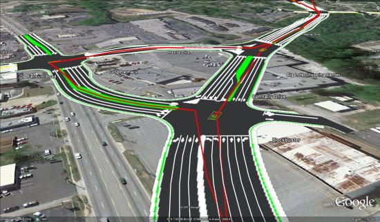
hwy92.jpg

As you can see from the image above and the video below, this project will make some massive changes to the layout of the road:

During recent meetings, the video was shown for the audience to view, and the presenters had the KMZ file loaded so they could walk through any questions that viewers might have.

Croy Engineering created the file for the City of Douglasville for use in the public information portion of the project concept phase. Greg Teague, Director of Engineering Services and Wayne McGary were the driving force behind the creation of the kmz file and movie.

For a project like this, Google Earth seems to be the perfect way to show it off. Novice users can watch the fly-through video, while more advanced users can use the KMZ to dig in deep.

The only thing that would make this better is the addition of 3D buildings and trees to help get a better feel for the affected area, but that will come over time as Google continues to expand those into more areas of the world.

Geotagging photos with Panoramio and Google Latitude

It is 9 a.m. and the thermometer shows -15°C. I have a Nexus S with Google Latitude in my left pocket and my new Lumix LX-5 in the right one. I am in Davos and I am ready for a fantastic day of skiing when I decide to use the new feature of Panoramio: geotagging photos with Google Latitude.

Panoramio is a community photos website that enables digital photographers to geo-locate, store and organize their photographs — and to view those photographs in Google Earth.

Google Latitude allows you to share your location with friends and view their location on a map. When enabled, Google Latitude History allows you to store your previous locations and this allows you to match your photos with the locations stored in Google Latitude History.

By combining Panoramio and Google Latitude your photos get geotagged automatically as the time stamp of the photos is matched with your location record in Google Latitude History. To use this feature you need to explicitly enable it in your Settings page in Panoramio. With your permission, Panoramio will access your Google Latitude History to find out your location at the time when your photos are taken, so make sure the time in your camera is correct and it matches the value you entered in the Panoramio Settings page.

Using Google Latitude while skiing allows you to find your friends when you get lost on the slopes, and at the same time it allows you to focus on taking nice photos not worrying about the location where you are taking them.

Mapping photos within the city is normally not a problem as you can easily remember street names, points of interest, etc. It is much more difficult to do it in the countryside and that is why I decided to give the feature a whirl while skiing in Davos:

Thanks to Google Latitude, my photos were geotagged just after uploading them in Panoramio. The day was great, snow was perfect, weather was amazing and when I arrived home my photos were already geo-positioned.

For more information about this feature please check our help content and as always we will be happy to hear your feedback in the Panoramio forum.

Street Slide: Coming Soon to Bing?

Systems such as Google Street View and Bing Maps Streetside enable users to virtually visit cities by navigating between immersive 360° panoramas, or bubbles. The discrete moves from bubble to bubble enabled in these systems do not provide a good visual sense of a larger aggregate such as a whole city block. Multi-perspective “strip” panoramas can provide a visual summary of a city street but lack the full realism of immersive panoramas.

The movie below provides an overview of the system:


In a paper at SIGGRAPH Microsoft presented Street Slide, which combines the best aspects of the immersive nature of bubbles with the overview provided by multiperspective strip panoramas. They demonstrated a seamless transition between bubbles and multi-perspective panoramas presenting a dynamic construction of the panoramas which overcomes many of the limitations of previous systems.

As the user slides sideways, the multi-perspective panorama is constructed and rendered dynamically to simulate either a perspective or hyper-perspective view. This provides a strong sense of parallax, which adds to the immersion.

You can view the paper here (13Mb, .pdf), with Microsofts Patent recently approved, it looks like this should be coming to Bing soon.