WebGL experience for the modern browser

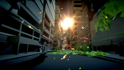
Last August, we released “The Wilderness Downtown”, a music experience that brought together HTML5 and JavaScript, as well as the Google Maps and Street View APIs. Today, we’re excited to introduce our newest project, “3 Dreams of Black”, made with WebGL, HTML5 and JavaScript, and designed for modern browsers like Google Chrome. We previewed this music experience yesterday with web developers at Day 2 of the Google I/O keynote.

“3 Dreams of Black” takes you on a journey through three dream worlds constructed through a combination of rich 2D drawings and animations interwoven with interactive 3D sequences. Throughout various points in these dream worlds, you can grab your mouse and guide the protagonist’s point of view through the experience. This music experience also includes a 3D model creator that allows you to create your own relics and contribute to the shared collective dream. “3 Dreams of Black” is written and directed by Chris Milk, and developed with a few folks here at Google.

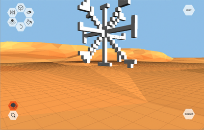
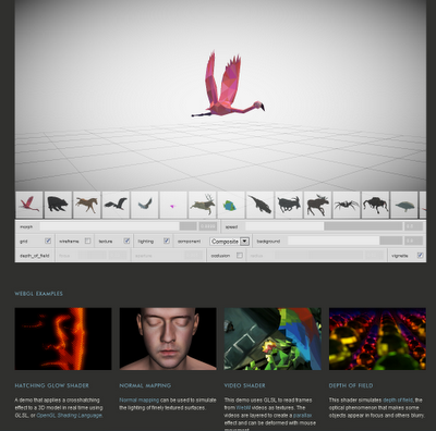
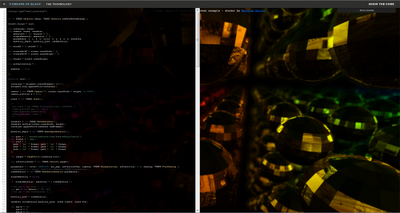
In creating “3 Dreams of Black”, we’ve had the opportunity to build many tools, libraries, and models. We’ve fully opened up the source code and made it available for web developers to tinker with us at www.ro.me/tech. In addition to the code, a few other highlights include eight WebGL demos, a fun model viewer for interacting with some of the animals from the web experience, and the Three.js 3D library used for building the experience. In addition, a big part of the project was to define a good pipeline for getting all the animals and environment models right in WebGL — for this, we extended Blender with custom plugins so we could manipulate and export the data with ease.

“3 Dreams of Black” is set to the song “Black” off the album ROME, presented by Danger Mouse & Daniele Luppi, featuring Jack White and Norah Jones on vocals, to be released soon on the record label EMI. Because it’s built in WebGL, it requires a WebGL-supported browser like Chrome, and Windows Vista / Mac OS X 10.6 and above to help ensure that your computer has the necessary and up-to-date graphics drivers. We hope you’ll take a moment to dive into the experience and the developer resources at www.ro.me

Ricardo Cabello is a designer/developer in the Google Data Arts Team. He is the creator of several popular Chrome Experiments, including Google Gravity, Ball Pool, and Harmony.

New Google Imagery – Week of May 16th

The Google Earth and Google Maps Imagery Team has just published its latest batch of satellite and aerial imagery, and as always, there are all kinds of fascinating sites and features to check out.

It’s mid-May and summer is just around the corner. That means vacation! And since many of us like to head to the water for our leisure time, we’ve compiled examples of a few coastal areas that have received updated imagery in our latest release.
In the States, premiere beach vacation spots include the coral-sand beaches that line Miami, Florida. Below is a stretch of the world-famous South Beach within the City of Miami Beach’s City Center district. This high-resolution aerial image was taken this past March, during Spring Break.


44th St. Beach, Miami, Florida


If hot, crowded beaches aren’t your thing, there are many cooler places (literally) you could spend your leisure time exploring. Below is a high-resolution aerial image from this past April of Bear Glacier in the Kenai Fjords National Park, Alaska. In this image, you can see the glacier toe as well as the ice, meltwater, and debris it deposits. This valley outflow glacier is sourced from the Harding Icefield, the largest icefield contained entirely within the United States. If you’re viewing this in Google Earth, be sure to use the Historical Imagery time slider to view how the glacier’s size has changed over time.

Bear Glacier, Kenai Fjords National Park, Alaska


Finally, here’s a recent satellite image of the entertainment center in the bustling coastal city of Qingdao, in the Shandong Province, China. The city was named China’s most livable city in 2009, and from the image below you can understand why; there are many places to enjoy such as beaches, sport complexes, and the beautiful public space, Hui Quan Square. Indeed, a nice place to visit and explore on your next summer vacation – whether it’s in-person or online. When viewing this area in Google Earth or Maps, you can also explore other parts of the image, such as the finishing touches being put on the Haiwan Bridge, the world’s largest water bridge, spanning 26.4 miles.


Hui Quan Square, Qingdao, China


Do you have a place you love for which you’d like to receive a notification when the Earth and Maps Imagery team updates the site? We’ve got just the tool: The Follow Your World application!

As always, these are but a few examples of the types of features that can be seen and discovered in our latest batch of published imagery. Happy exploring!

High Resolution Aerial Updates:
USA: Myrtle Beach, Miami, Palm Beach, Lake City, Lynchburg, Lenoir, Dallas, Grand Rapids, Anchorage, Kenai, Tyonek

Countries/Regions receiving High Resolution Satellite Updates:
Albania, Algeria, Angola, Antarctica, Argentina, Australia, Austria, Azerbaijan, Bahamas, Bangladesh, Belarus, Belize, Benin, Bhutan, Bolivia, Bosnia and Herzegovina, Botswana, Brazil, Bulgaria, Burkina Faso, Canada, Cape Verde, Chad, Chile, China, Colombia, Costa Rica, Croatia, Cuba, Cyprus, Côte d’Ivoire, Democratic Republic of the Congo, Djibouti, Dominican Republic, Ecuador, Egypt, El Salvador, Eritrea, Estonia, Ethiopia, Fiji, Finland, France, French Guiana, Gambia, Germany, Greece, Grenada, Guam, Guatemala, Haiti, Hong Kong, Hungary, Iceland, India, Indonesia, Iran, Ireland, Israel, Italy, Jan Mayen, Japan, Jordan, Kazakhstan, Kenya, Kuwait, Laos, Latvia, Lebanon, Lesotho, Lithuania, Madagascar, Malawi, Malaysia, Mali, Mauritania, Mexico, Moldova, Mongolia, Morocco, Mozambique, Myanmar, Namibia, Nepal, Netherlands, New Caledonia, New Zealand, Niger, Nigeria, North Korea, Norway, Pakistan, Palmyra Atoll, Panama, Papua New Guinea, Paraguay, Peru, Philippines, Poland, Portugal, Qatar, Romania, Russia, Samoa, Saudi Arabia, Senegal, Serbia, Slovakia, Slovenia, Somalia, South Africa, Spain, Sri Lanka, St. Helena, St. Vincent and the Grenadines, Sudan, Suriname, Svalbard, Swaziland, Sweden, Switzerland, Syria, São Tomé and Príncipe, Taiwan, Tanzania, Thailand, Trinidad and Tobago, Tunisia, Turkey, Uganda, Ukraine, United Arab Emirates, United Kingdom, United States, Uruguay, Venezuela, Vietnam, West Bank, Western Sahara, Yemen, Zambia, Zimbabwe

These updates are now available in both Google Maps and Google Earth. To get a complete picture of where we updated imagery, download this KML for viewing in Google Earth.