Armstrong on Being Awake

Time is limited, so I better wake up every morning fresh and know that I have just one chance to live this particular day right, and to string my days together into a life of action, and purpose.”

–Lance Armstrong (1971 – )

American cyclist

7-time winner of the Tour de France

Cancer survivor

If asked, what would you and your team say are your core values?

In the U.S. Marine Corps publication, “Sustaining the Transformation” (pdf), their’s are listed as Honor – Courage – Commitment. If you lead a team, the foreword (at a minimum) by General Krulak is time well-spent. It, along with the Fortune story “From Wharton to War“, is great inspiration for creating a special team of people (as a leader with a title or not).

And that’s what you want to be a part of, don’t you? A special team of people?

So many great teamwork points in the Fortune piece. We love the “bino” request. If you’ve got teenagers or college students, consider passing it along to them and then discussing it (we need them ready when they join us in the world). It’s a little Be No Ego-like.

_____

Google SketchUp 8 For Dummies

When I first downloaded SketchUp years ago, I thought I was the coolest guy on the block because I could push/pull a square into a cube. Then I went online and saw what some other folks were modeling and realized I needed to up my game FAST. So like many folks, I turned to (my now colleague) Aidan Chopra’s Google SketchUp For Dummies book.

I learned a lot from this Dummies book, so I’m especially proud to be able to announce that the newest edition of Google SketchUp For Dummies is on bookshelves now. This new edition is fully revised and updated to cover all the tastiness we packed into SketchUp 8—both free and Pro. You can find the book online and at bricks-and-mortar bookstores.

If you’re new to SketchUp, the book is a great primer. It will teach you how to (among other things):

  • Navigate SketchUp’s user interface.
  • Build a model from scratch.
  • Create and use components.
  • View and present your models.
  • Use LayOut to create documents and presentations.

A detailed table of contents is available for download from the publisher’s website. If you’re a grizzled SU veteran or already own an older version of this book, I’d still recommend checking out the newest edition. It contains several new sections about:

  • Adding additional floor levels to your models
  • Working with solids and the Solid Tools
  • Using the revised Match Photo toolset
  • Geo-modeling with SketchUp 8 and Building Maker
  • Presenting your designs with LayOut in SketchUp Pro
  • Finding and making use of Ruby scripts

There are also two additional chapters available for free download on the website, and the book’s accompanying YouTube channel has 62 supplemental videos that walk through the many techniques and examples presented in the book.

I like to tease Aidan and say that I only read half of his book. What I don’t tell him is I read the first few chapters straight through to get me up and running, but I refer to the advanced chapters often to brush up my modeling skills! In other words, this is a great resource no matter what your level of SketchUp expertise.

Great User Created Maps Chronicling Egypt

During the crisis in Egypt, third-party Geo developers helped the international community understand the situation and keep persons affected by the crisis safe through the use of innovative new tools. These same tools can be replicated by anyone in any crisis situation. In the developer examples below, three things jump out as particularly striking: How quickly these maps were built and put into action, some within hours of the first protests; how developers (many contributing independently) from all over the world worked together to get these maps up and running; and how geo-context has become extremely important for the international community in understanding and responding to any crisis, be it natural or man-made.

NY Times – Mapping the Protest in Cairo Day by Day
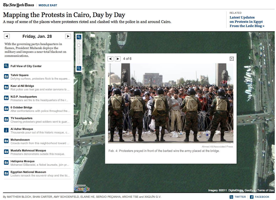
In this map, the New York Times has plotted the locations of the protests and clashes with police. There are also pictures, videos and contextual information provided in the icon info bubbles.

Al Jazeera – Mapping the Day of Wrath
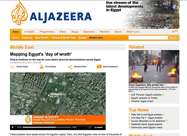
This website features a video illustrating the geographic spread of the protests using fly-over animations in Google Earth. The same webpage includes maps with information about protests in Cairo and throughout Egypt.

Hypercities Egypt
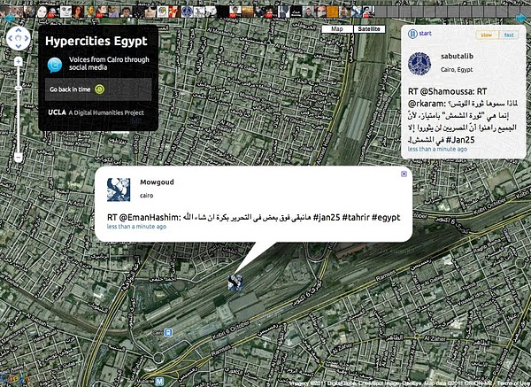
Twitter’s real-time updates have become an invaluable tool for the Egyptian protest organizers, observers and citizens looking to stay safe. Hypercities Egypt used Google Maps to display geolocated tweets as they came streaming in. Also, view another Egypt Twitter map created by MiBazaar.

GeoEye Tahrir Square Imagery
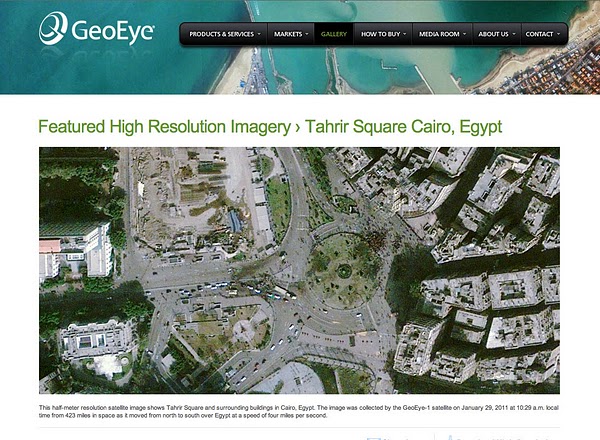
The imagery above is of Tahrir Square on January 29, 2011 at around 10:30am local time from more than 400 miles above. This imagery is exclusively viewable in Google Earth (and the Earth API) using the historical imagery tool. The imagery highlights GeoEye’s stunning ability to respond to world events and capture timely imagery.

Egypt Protests in Google My Maps by Storyful.com
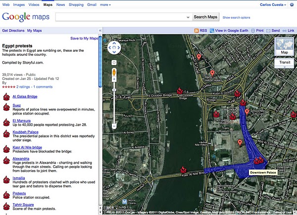
During the crisis, many Geo developers and persons without a Geo developer background collaborated on Google My Maps to chronicle the events geographically as they unfolded, such as this one by Storyful. Using the My Maps tool, anyone with access to Google Maps could create a collaborative mash-up with custom icons, colored polygons, content rich info-bubbles and many other features. Once completed, the map can be shared globally through My Maps or embedded on a website. Access can also be restricted to a select group of people if need be. Learn more at http://maps.google.com/getmaps.

———–

How you can help: During a crisis situation, up-to-date maps are often crucial for organizing humanitarian aid and effective response. In many regions, however, accurate and local map data is sparse, out of date, or not available at all. You can add your geographic knowledge to Google Maps by contributing map edits in Google Map Maker, which is currently available in select countries and territories.