Google Maps: See maps on your mobile browser

With 40% of Google Maps usage on mobile devices, we want you to have a consistent Google Maps experience wherever you use it. So, today we’re announcing our updated Google Maps experience for mobile browsers on Android and iOS.

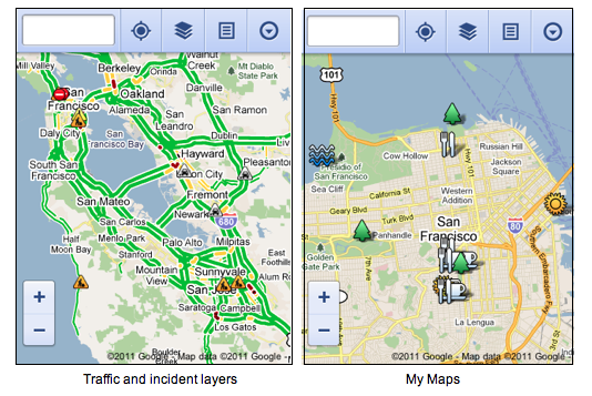
Now, when you visit maps.google.com on your phone or tablet’s browser and opt-in to share your location, you can use many of the same Google Maps features you’re used to from the desktop. This will allow you to:

  • See your current location
  • Search for what’s nearby with suggest and auto complete
  • Have clickable icons of popular businesses and transit stations
  • Get driving, transit, biking, and walking directions
  • Turn on satellite, transit, traffic, biking, and other layers
  • View Place pages with photos, ratings, hours, and more
  • When signed into your Google account, access your starred locations and My Maps

    This past weekend, I was at a team off-site at a ropes course and needed to find a good deli spot to grab lunch. I opened Google Maps on my mobile browser and searched to locate a popular deli nearby. A few finger taps later, I had viewed photos and reviews on the deli’s Place page and found the quickest way to get there using driving directions- all from my mobile browser.

    Google Maps for mobile browsers is platform independent – you will always get a consistent experience and the latest features without needing to install any updates, no matter what phone you use. 

    To get started exploring Google Maps in your mobile browser, go to http://maps.google.com or any domain where Google Maps is available.
    Reviewed: Fujifilm FinePix XP30

    Fujifilm FinePix XP30


    Photography Blog has a review of the Fujifilm FinePix XP30, a rugged pocket digital camera with built-in GPS. The review cites some problems with both the camera’s ruggedness and its GPS. “Putting GPS on the camera is a great idea, but living in England as we do, we couldn’t get it to work because of the bad weather we experienced at the time of testing. There are good GPS systems on the market that can get a signal when indoors and in tunnels but the XP30 can’t even get through clouds.”

    Google Earth: The Battle of Fort Sumter

    Over the years, we’ve covered a few Civil War related projects, such as the Pennsylvania Civil War Trails, but there really haven’t been too many that have caught our attention. Darian Robbins is changing that.

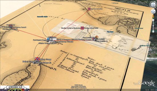
    His blog showcases a variety of 3D models from civil war times (including many buildings which are still around today), but his latest piece is something to see — the Battle of Fort Sumter.

    sumter.jpg

    The KMZ file, which can be found in the 3D Warehouse, contains a ton of information including:

    • 3D version of Fort Sumter before it was attacked.
    • 3D version of the Floating Battery of Charleston that was used to fire on Fort Sumter.
    • Historical map overlays of the locations of various Confederate Batteries that fired on Fort Sumter.
    • Geo-located Civil War Era photos of the damage Fort Sumter endured and the locations of the Confederate batteries.
    • Twitter Feeds of the Washington Post’s twitter campaign of the Civil War.
    • Links to Qwiki and Wikipedia articles and media about the Battle and various locations.

    His inspiration for this model was the commemoration of the 150th anniversary of the Battle, which took place April 12-13, 1861.