The Animals in Google Earth


Nearly six years ago, the “National Geographic Magazine” layer was added to Google Earth. While we haven’t discussed it much lately, it remains one of the great gems inside of Google Earth. You can find it under the “Gallery” layer in Google Earth.

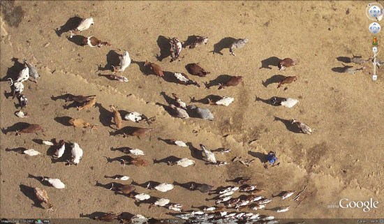
One of the best parts of that layer is the “Africa Megaflyover” photos that were captured by Michael Fay. Michael took over 92,000 photos while flying across parts of Africa, and hundreds of them are visible in Google Earth. The quality of the images is stunning, as shown here.


camels.jpg


User “Reggie98” in the Google Earth Community built a great collection of placemarks to highlight the African animals captured in these photos, and organized them by animal type. The original post is from 2005, but still does a great job of showing off the animals.


cattle.jpg


There is a lot of great stuff to explore in the National Geographic layer, so go check it out. Also, with nearly 1.3 million subscribers, the Google Earth Community continues to be a great way to meet other Google Earth users and find answers to your questions. If you haven’t been out there in a while, we certainly suggest you check it out.

Latitude API

With the recent addition of OAuth 2.0 support for the Latitude API, it is now easier than ever to start writing applications that utilize users’ location history or current location if they have opted in to sharing this information.

This post includes some examples of how you can use the powerful Latitude API to make compelling location-based applications.
Location History
There are many interesting ways you can use location history to create an interesting app. For example, Latify shows my location history on my Android phone so I can easily keep track of where I’ve been. You can use location history to answer questions like “Where was I on September 17th?” or you can analyze location history to show interesting stats. You can also export location history to Google Fusion Tables.
The possibilities expand when you use location history in conjunction with other data sets. For example, you can show location history lined up with transaction history, RSS feeds, or photo albums so users can see exactly where they were for a particular purchase, news event, or photo.
Current Location
The Latitude API allows you to access a user’s current location from a mobile device or a web server. For example, Moveable Weather allows users to call a phone number that tells them the weather based on their current Latitude location.
If you’re writing a mobile group messaging app, you can use the Latitude API to let users opt in to location sharing, allowing everyone in the group to see everyone else’s current location, without needing any location logic in your app.
These are just a few examples of the features of the Latitude API, which also includes storing location history, accessing city level location, and deleting location history. Check out the documentation to get started, or try browsing featured applications to get an idea of what you can build.


Garmin Forerunner 210 GPS Watch

The Garmin Forerunner 210 GPS Watch is ideal for outdoor athletes who want speed, distance and heart rate data for pacing while running, biking, skiing, rollerblading and more. Download your adventures to Google Earth and re-trace your steps or bring home maps to future adventures. It adds a soft chest strap and intervals to the Garmin Forerunner 110 package and also a foot pod for working out indoors with the Club Bundle.

http://www.youtube.com/v/S9WEXJsg2Rg?f=videos&app=youtube_gdata